MyTopo
Philpott Lake Virginia US Topo Map
Couldn't load pickup availability
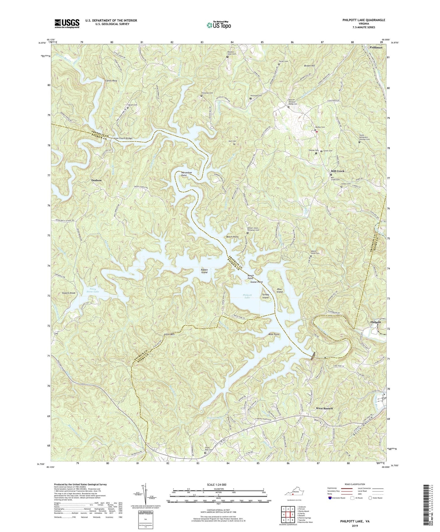
2019 topographic map quadrangle Philpott Lake in the state of Virginia. Scale: 1:24000. Based on the newly updated USGS 7.5' US Topo map series, this map is in the following counties: Franklin, Patrick, Henry. The map contains contour data, water features, and other items you are used to seeing on USGS maps, but also has updated roads and other features. This is the next generation of topographic maps. Printed on high-quality waterproof paper with UV fade-resistant inks.
Quads adjacent to this one:
West: Charity
Northwest: Endicott
North: Ferrum
Northeast: Rocky Mount
East: Bassett
Southeast: Martinsville West
South: Sanville
Southwest: Patrick Springs
Contains the following named places: Adkins - Stone Cemetery, Beards Creek, Beech Point, Bowens Branch, Bowens Creek, Bowens Creek Recreation Area, Bryant Lakes, Burch Hollow, Butter Run, Calico Rock, Cemetery, Cooper Creek, Cow Branch, Deer Island, Deer Island Recreation Area, Dehart - Jones - Prillaman Cemetery, Dodson, Fairy Stone Dam, Fairy Stone Lake, Fairy Stone State Park, Faith Church, George Martell Prillaman Family Cemetery, Goblintown Creek, Goose Point, Goose Point Recreation Area, Green Branch, Hale Creek, Henry Volunteer Fire Department Company 14, Horseshoe Point, Horseshoe Point Recreation Area, Hurt Cemetery, Ingram Cemetery, Jackson Run, Jamison Mill Park Campsite, Jamison Mill Recreation Area, Knob Church, Langlad Camp Area, Little Mountain, Little Town Creek, Lovell Cemetery, Meadors - Sloan Cemetery, Mill Creek, Mill Creek Baptist Church Cemetery, Mill Creek Missionary Baptist Church, Mines Branch, Mines Branch Recreation Area, Mize Point, Mize Point Recreation Area, Mount Hermon Church, New Light Church, Nicholas Creek, Osley Branch, Otter Creek, Peoples Church, Philpott, Philpott Dam, Philpott Lake, Philpott Lake Recreation Area, Prilliman, Prilliman Cemetery, Rabbit Island, Radley Cemetery, Ratcliff-Whitlow-Young Cemetery, Rennet Bag Creek, Rennet Bag Recreation Area, Roland Branch, Ryans Branch, Ryans Branch Campsite, Ryans Branch Recreation Area, Salthouse Branch, Salthouse Branch Campsite, Salthouse Branch Recreation Area, Shady Rest Cemetery, Spring Branch, Spring Cove Park Recreation Area, Star of Bethlehem Church, Stone - Bondurant - Johnson Cemetery, Stuarts Knob, Thomas Cemetery, Town Creek, Turkey Island, Turkey Island Recreation Area, Turner Cemetery, Twin Ridge Marina, Twin Ridge Recreation Area, Union Chapel, Union Church, Union Church Bridge, West Bassett, WODY-AM (Bassett), ZIP Code: 24102