MyTopo
Richlands Virginia US Topo Map
Couldn't load pickup availability
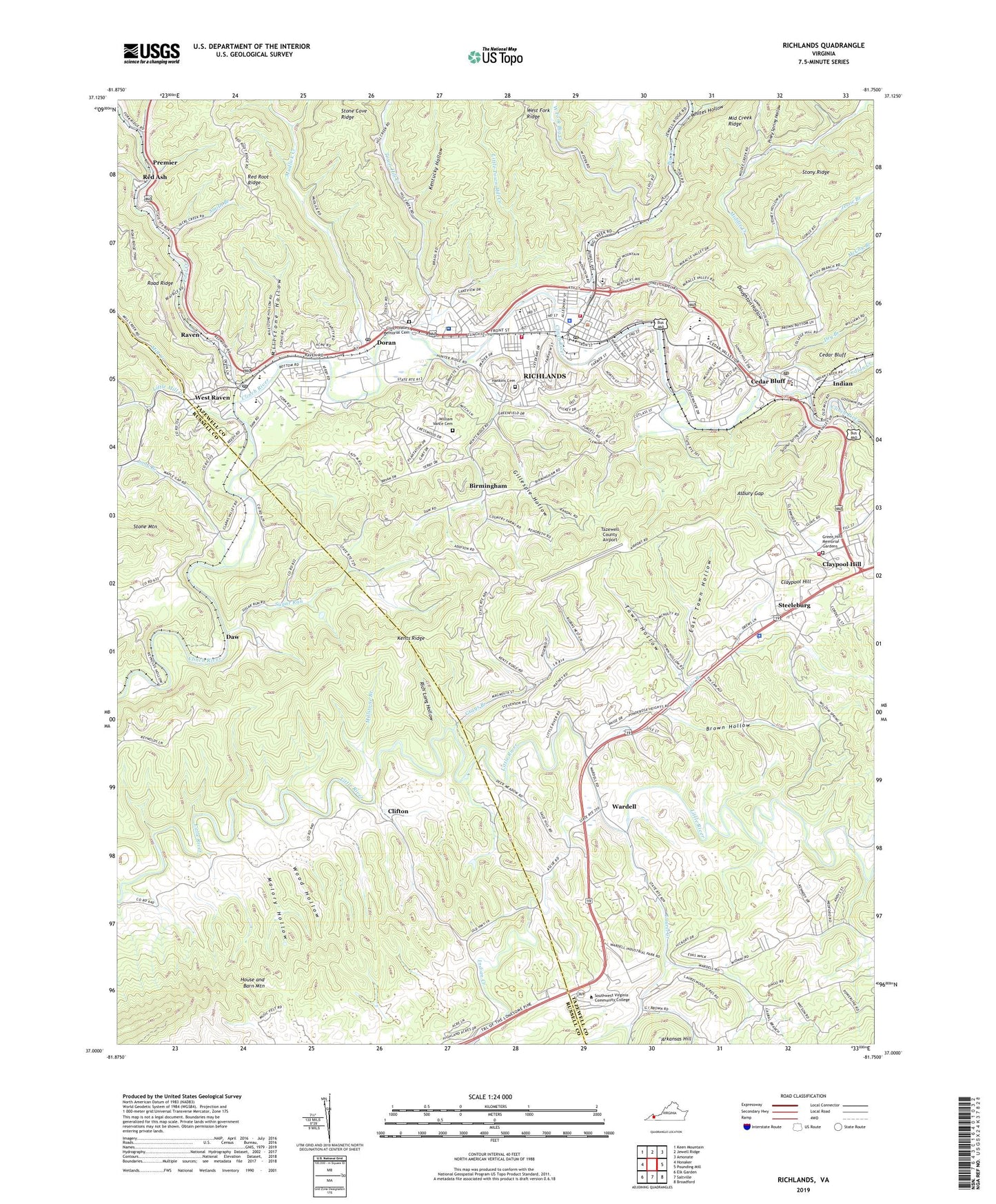
2022 topographic map quadrangle Richlands in the state of Virginia. Scale: 1:24000. Based on the newly updated USGS 7.5' US Topo map series, this map is in the following counties: Tazewell, Russell. The map contains contour data, water features, and other items you are used to seeing on USGS maps, but also has updated roads and other features. This is the next generation of topographic maps. Printed on high-quality waterproof paper with UV fade-resistant inks.
Quads adjacent to this one:
West: Honaker
Northwest: Keen Mountain
North: Jewell Ridge
Northeast: Amonate
East: Pounding Mill
Southeast: Broadford
South: Saltville
Southwest: Elk Garden
This map covers the same area as the classic USGS quad with code o37081a7.
Contains the following named places: Apostolic Church of Jesus Christ, Asbury Gap, Big Creek, Birmingham, Brown Hollow, Cedar Bluff, Cedar Bluff Elementary School, Cedar Bluff Police Department, Cedar Bluff Post Office, Claypool Hill, Claypool Hill Census Designated Place, Claypool Hill Mall Shopping Center, Clifton, Clinch Valley Medical Center, Clinch Valley Memorial Cemetery, Coal Creek, Cottage Hill School, Dalton Addition, Davis Chapel, Daw, Doran, Doran Census Designated Place, Doran Post Office, Doughton Hollow, Dry Branch, East Town Hollow, Field-Scott Mines, First Apostolic Christian School, First Assembly of God Church, First Baptist Church, First United Methodist Church, Gillespie Hollow, Gray Branch School, Grays Branch, Green Hills Memorial Gardens, Hankins Cemetery, Hill City School, Hill Creek Church, Hill Creek School, Humana Hospital-Clinch Valley Heliport, Indian, Indian Creek, Jessie Branch, Jones Chapel, Katie Branch, Kents Ridge, Kentucky Hollow, Lake Park, Laurel Creek, Laymen Chapel Methodist Protestant Church, Left Fork Coal Creek, Left Fork Indian Creek, Little Mill Creek, Little Star Church, Little Town Hill Creek, Long Branch, Macedonia Church, Malory Hollow, Mattie Williams Hospital, McCoy Branch, McGlothlin School, Middle Creek, Middle Creek Ridge, Mill Creek, Millstone Branch, Millstone Hollow, Mudlick Creek, New Light Holiness Church, Paint Lick School, Paintlick, Pentecostal Holiness Church, Piney Spring Hollow, Premier, Raven, Raven Census Designated Place, Raven Elementary School, Raven Post Office, Red Ash, Red Ash School, Red Oak Ridge School, Rich Long Hollow, Richlands, Richlands Christian Academy, Richlands Church of Christ, Richlands Elementary School, Richlands Fire and Rescue Station 1, Richlands Fire and Rescue Station 2, Richlands Fire and Rescue Station 3, Richlands High School, Richlands Mall Shopping Center, Richlands Middle School, Richlands Municipal Airport, Richlands Police Department, Richlands Post Office, Richlands Presbyterian Church, Richlands Town Hall, Road Ridge Church, Smith Branch, Southwest Virginia Community College, Steeleburg, Steeleburg School, Stony Ridge, Sugar Run, Sulphur Spring Hollow, Tazewell County Airport, Town Hill Creek, Town Hollow, Town of Cedar Bluff, Town of Richlands, Virginia State Police Division 4 Area 28 Office, Wardell, West Fork Big Creek, West Fork Ridge, West Raven, Whites Hollow, Whites School, William Vance Cemetery, Wood Hollow, WRIC-AM (Richlands), WYRV-AM (Cedar Bluff), Zeke Creek, ZIP Codes: 24609, 24612, 24641