MyTopo
Bon Air Virginia US Topo Map
Couldn't load pickup availability
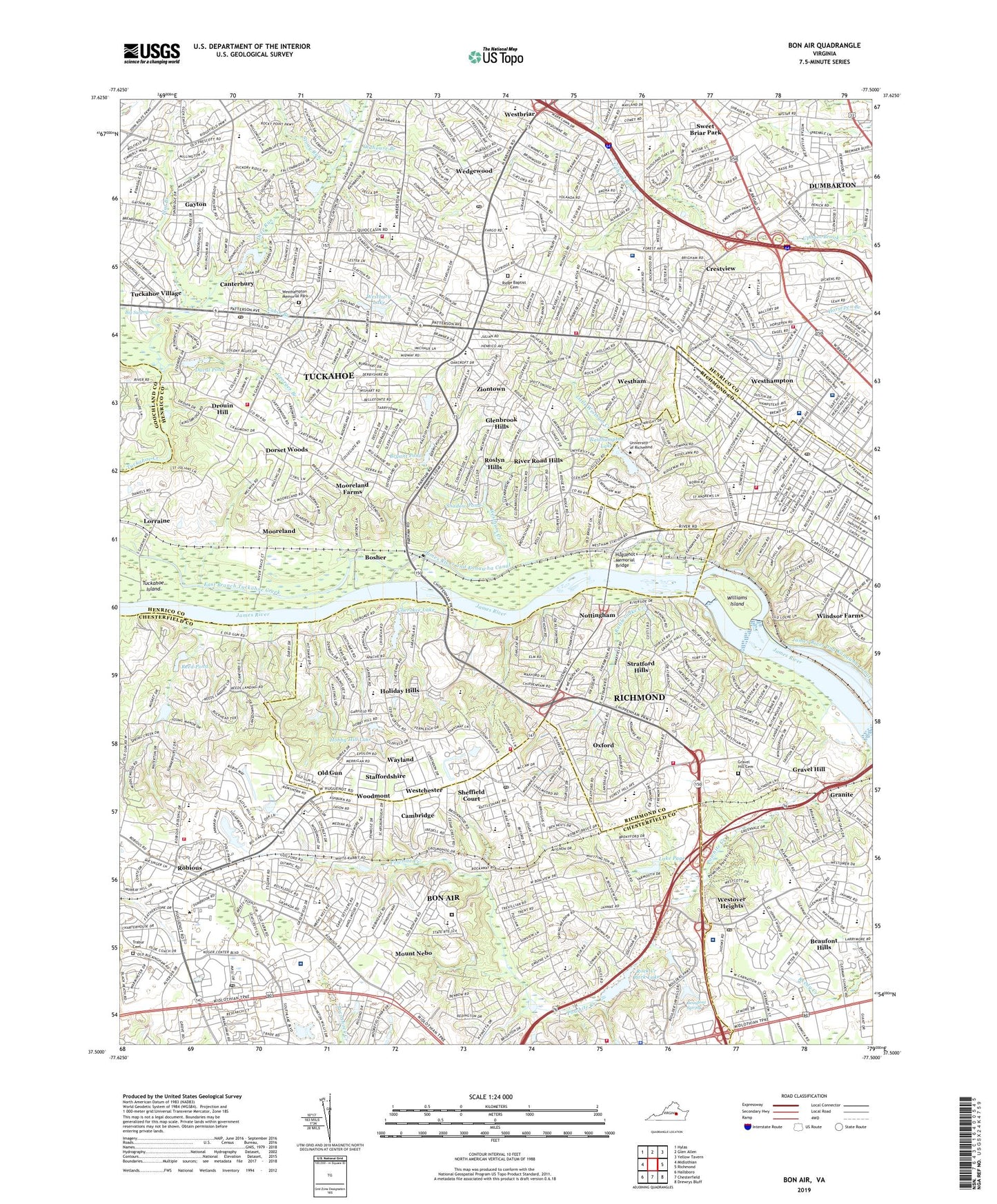
2022 topographic map quadrangle Bon Air in the state of Virginia. Scale: 1:24000. Based on the newly updated USGS 7.5' US Topo map series, this map is in the following counties: Henrico, Richmond (city), Chesterfield, Goochland. The map contains contour data, water features, and other items you are used to seeing on USGS maps, but also has updated roads and other features. This is the next generation of topographic maps. Printed on high-quality waterproof paper with UV fade-resistant inks.
Quads adjacent to this one:
West: Midlothian
Northwest: Hylas
North: Glen Allen
Northeast: Yellow Tavern
East: Richmond
Southeast: Drewrys Bluff
South: Chesterfield
Southwest: Hallsboro
This map covers the same area as the classic USGS quad with code o37077e5.
Contains the following named places: Beaufont Hills, Beaufont Mall Shopping Center, Beaufont Spring, Beaufort Estates, Bellgrade Shopping Center, Bethlehem School, Beverly Hills Shopping Center, Bon Air, Bon Air Census Designated Place, Bon Air Christian School, Bon Air Elementary School, Bon Air Historic District, Bon Air Manor, Bon Air Primary School, Bon Air School for Girls, Bosher, Bosher Dam, Brighton Green, Brookwood Estates, Bryant Pond, Buford Estates, Cabin Branch, Cambridge, Canterbury, Canterbury Dam, Canterbury Lake, Canterbury Shopping Center, Charles M Johnson Elementary School, Cherokee Hills, Cherokee Lake, Chesterfield Mall Shopping Center, Chesterfield Towne Center Shopping Center, Chesterfield Village, Cheswick Park, Chippenham Hospital, Chippenham Hospital Heliport, Chippenham Village, Collegiate High School, Collegiate School, Commerce Center, Country Club of Virginia James River Course, Country Club of Virginia Westhampton Course, Crestview, Crestview Elementary School, Crestwood Elementary School, Crestwood Farms, Crossroads Shoppers World Shopping Center, Deep Run, Dorset Woods, Douglas S Freeman High School, Drouin Hill, Dumbarton Census Designated Place, Duval Pond, East Branch Tuckahoe Creek, Elizabeth D Redd Elementary School, Encompass Health Rehabilitation Hospital of Richmond, Fairway Acres, Fernleigh, First Presbyterian Nursery School, Fisher Park, Flat Branch, Forest Hill Farms, Gaskin Road Plaza Shopping Center, Gayton, Gayton Crossing Shopping Center, Georges Branch, German School, Girl Scout Camp, Glen Echo Place, Glenbrook Hills, Glenbrook Pond, Grand Summit, Granite, Granite School, Gravel Hill, Gravel Hill Cemetery, Greenfield Elementary School, Grove Avenue Christian School, HDH Heliport, Henrico Doctors Hospital Forest Campus, Highland Hills, Hobby Hill Dam, Hobby Hill Farms, Hobby Hill Lake, Holiday Hills, Huguenot Farms, Huguenot High School, Huguenot Memorial Bridge, Huguenot Park, Huguenot Village Shopping Center, Industrial Home, J B Fisher Elementary School, Jack and Jill School, Jackson Davis Elementary School, James River and Kanawha Canal, Jepson School of Leadership Studies, Johnston - Willis Hospital, Koger Busines Center, Lake Cherokee Dam, Lake Page, Lake Page Dam, Little Westham Creek, Lorraine, Management Institute, Marymount Elementary School, Maybeury Elementary School, Merchants Walk Shopping Center, Midlothian Mall Shopping Center, Miles Jeromes Jones Elementary School, Mills E Godwin High School, Moorefield Industrial Park, Mooreland, Mooreland Farms, Mount Nebo, Norman Hall School, Nottingham, Old Gun, Olde Town Shopping Center, Oldhouse Branch, Oxford, Parham Plaza Shopping Center, Parkway Plaza Shopping Center, Patterson at Libbie Shopping Center, Pemberton Elementary School, Pitt Basement Field, Pittaway Farms, Powhite Park, Quioccasin, Quioccasin Middle School, Ramsgate, Rattlesnake Creek, Raymond B Pinchbeck Elementary School, Reed Dam, Reed Pond, Regency Square Shopping Center, Richmond Research Institute, Ridge Baptist Cemetery, Ridge Elementary School, Ridge Shopping Center, Rio Vista, River Road Hills, River Road Shopping Center, Riverside School, Robins School of Business, Robious, Robious Athletic Complex, Robious Elementary School, Robious Hall Shopping Center, Robious Middle School, Rock Creek Park Dam, Rock Creek Park Lake, Roslyn Hills, Saint Bridget School, Saint Catherine's School, Saint Christopher's School, Saint Edward - Epiphany Catholic School, Saint Mary's Catholic School, Saint Mary's Hospital, Saint Mastins School, School of Continuing Studies, Shaaf Pond, Shadow Pond, Sheffield Court, Sixty West Commercial Plaza, Skipwith Elementary School, Soccer/Track Complex, Southampton, Southampton Elementary School, Southhampton Hills, Southport Industrial Park, Spring Grove, Staffordshire, Stony Run, Stratford Hills, Stratford Hills Shopping Center, Sweet Briar Park, The Steward School, Thompson Middle School, Three Chopt Elementary School, Tinsleys, Trabur Cemetery, Tuckahoe, Tuckahoe Census Designated Place, Tuckahoe District, Tuckahoe Elementary School, Tuckahoe Island, Tuckahoe Middle School, Tuckahoe Shopping Center, Tuckahoe Village, Tuckahoe Village Merchants Square Shopping Center, Tuckahoe Village Shopping Center, Twin Valley Farms, Union School, University Commons Dam, University of Richmond, Van Darvall School, Virginia Institute of Research, Wayland, WBBL-AM (Richmond), WCVE-TV (Richmond), WDCE-FM (Richmond), Wedgewood, Westbriar, Westbury Lake, Westbury Lake Dam, Westchester, Westham, Westham Creek, Westhampton, Westhampton College Dean, Westhampton Day School, Westhampton Lake, Westhampton Memorial Park, Westlake Hills, Westover Gardens, Westover Heights, Westwood Golf Course, Williams Island, Williams Island Dam, Willow Oaks, Willow Oaks Country Club, WJRW-AM (Richmond), WMXB-FM (Richmond), Woodmont, WRIC-TV (Petersburg), WRNL-AM (Richmond), WRXL-FM (Richmond), WWBT-TV (Richmond), WXGI-AM (Richmond), Ziontown, ZIP Codes: 23173, 23225, 23226, 23229, 23235