MyTopo
Tappahannock Virginia US Topo Map
Couldn't load pickup availability
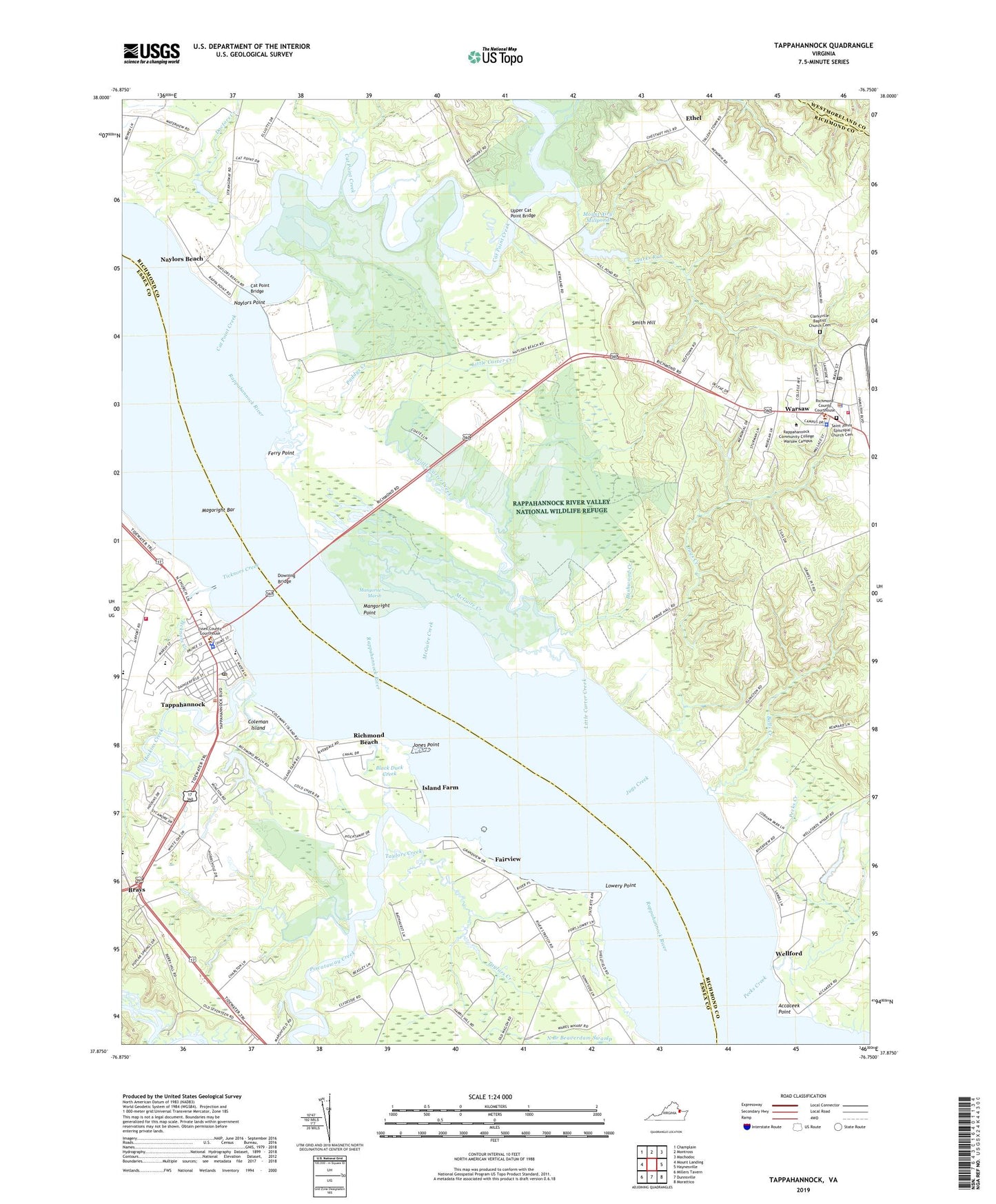
2019 topographic map quadrangle Tappahannock in the state of Virginia. Scale: 1:24000. Based on the newly updated USGS 7.5' US Topo map series, this map is in the following counties: Richmond, Essex, Westmoreland. The map contains contour data, water features, and other items you are used to seeing on USGS maps, but also has updated roads and other features. This is the next generation of topographic maps. Printed on high-quality waterproof paper with UV fade-resistant inks.
Quads adjacent to this one:
West: Mount Landing
Northwest: Champlain
North: Montross
Northeast: Machodoc
East: Haynesville
Southeast: Morattico
South: Dunnsville
Southwest: Millers Tavern
Contains the following named places: Accaceek Point, Accopatough Beach, Balls Creek, Belle Mount Vineyards, Black Duck Creek, Brays, Brays Fork, Brockenbrough House, Bushwood, Bushwood Creek, Carrington Place of Tappahannock, Cat Point Bridge, Cat Point Creek, Chesapeake Bay Governors School, Chestnut Hill Landing, Chestnut Hill Plantation, Clarks Run, Clarksville Baptist Church Cemetery, Clarksville Church, Coleman Island, Delano Dam, Dillard Dam, District 3, Doctors Creek, Downing Bridge, Essex County Sheriff's Office, Essex High School, Essex Intermediate School, Essex Public Library, Ethel, Fairview, Ferry Landing, Ferry Point, Hobbs Hole Golf Course, Hoskins Creek, Island Farm, Islington Landing, Jones Point, Jugs Creek, Little Carter Creek, Lowery Point, Lowerys Landing, Lowerys Point Landing, Magoright Bar, Mangoright Point, Mangorite Marsh, McGuire Creek, Menokin Baptist Church, Mount Airy Dam, Mount Airy Mill, Mount Airy Millpond, Mount Airy Plantation, Muddy Run, Naylors, Naylors Beach, Naylors Hole, Naylors Point, New Hope Church, Northern Neck Regional Jail, Oakwood Mobile Home Park, Paddys Creek, Pecks Creek, Piscataway Creek, Plant Patch Ferry, Rappahannock Christian Center, Rappahannock Community College - Warsaw Campus, Rappahannock River Valley National Wildlife Refuge, Red Hill, Richmond Beach, Richmond County Public Library, Richmond County Sheriff's Office, Richmond County Volunteer Fire Department Station 1, Riverside Estates Mobile Home Park, Sabine Hall, Saint Johns Episcopal Church, Saint Johns Episcopal Church Cemetery, Saint Margaret's School, Side Landing, Smith Hill, Strangeway Landing, Tappahannock, Tappahannock - Essex Volunteer Fire Department Station 1, Tappahannock District, Tappahannock Elementary School, Tappahannock Historic District, Tappahannock Junior Academy, Tappahannock Municipal Airport, Tappahannock Police Department, Tappahannock Post Office, Tappahannock Volunteer Rescue Squad, Taylors Creek, The Orchard Nursing Home, Ticknors Creek, Town of Tappahannock, Town of Warsaw, Turners School, Upper Cat Point Bridge, Victory Baptist Church, Wares Ferry, Warsaw, Warsaw Baptist Church, Warsaw Healthcare Center Nursing Home, Warsaw Police Department, Warsaw Post Office, Warsaw Village Retirement Center, Wellford, WNNT-AM (Warsaw), WNNT-FM (Warsaw), WRAR-AM (Tappahannock), WRAR-FM (Tappahannock), ZIP Code: 22572