MyTopo
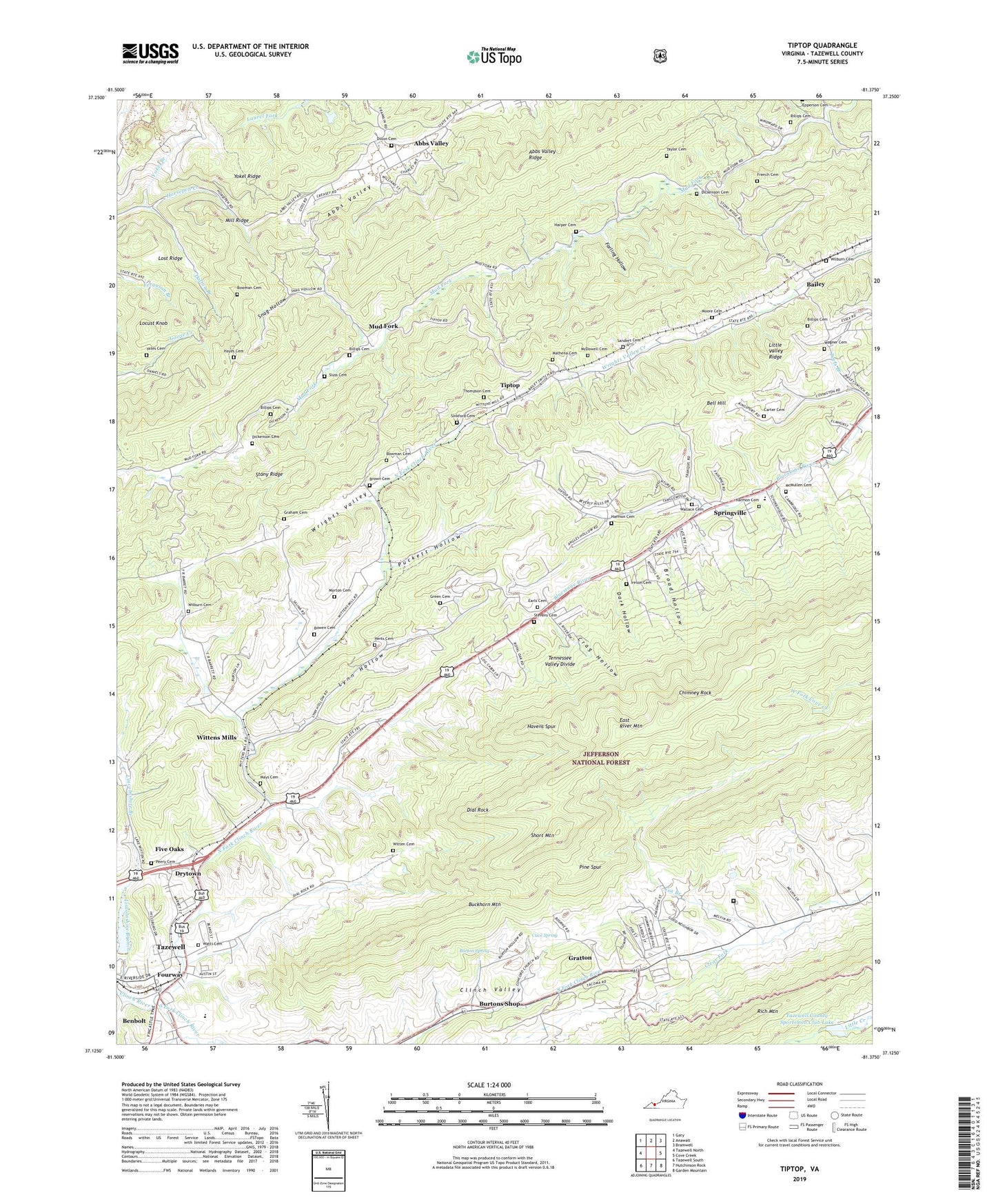
Tiptop Virginia US Topo Map
Couldn't load pickup availability
Also explore the Tiptop Forest Service Topo of this same quad for updated USFS data
2022 topographic map quadrangle Tiptop in the state of Virginia. Scale: 1:24000. Based on the newly updated USGS 7.5' US Topo map series, this map is in the following counties: Tazewell. The map contains contour data, water features, and other items you are used to seeing on USGS maps, but also has updated roads and other features. This is the next generation of topographic maps. Printed on high-quality waterproof paper with UV fade-resistant inks.
Quads adjacent to this one:
West: Tazewell North
Northwest: Gary
North: Anawalt
Northeast: Bramwell
East: Cove Creek
Southeast: Garden Mountain
South: Hutchinson Rock
Southwest: Tazewell South
This map covers the same area as the classic USGS quad with code o37081b4.
Contains the following named places: Abbs Valley, Abbs Valley Census Designated Place, Bailey, Bell Hill, Benbolt, Billips Cemetery, Blacks Presbyterian Church, Bowen Cemetery, Bowman Cemetery, Broad Hollow, Brown Cemetery, Burton Spring, Burtons Shop, Carter Cemetery, Cave Spring, Chimney Rock, Concord Church, Cox Branch, Crag Hollow, Cumberland Plaza Shopping Center, Dalton Branch, Dark Hollow, Dial Rock, Dickenson Cemetery, Dillon Cemetery, Drytown, Earls Cemetery, East River Mountain, Ebenezer Church, Farling Hollow, Fincastle Baptist Church, Five Oaks, Fourway, French Cemetery, Graham Cemetery, Gratton, Gratton Census Designated Place, Gratton School, Green Cemetery, Harmon Cemetery, Harmon Church, Harper Cemetery, Havens Spur, Hayes Cemetery, Herts Cemetery, Ireson Cemetery, Laurel Branch, Laurel School, Little Valley Ridge, Locust Knob, Lost Ridge, Lynn Hollow, Mathena Cemetery, Mays Cemetery, McDowell Cemetery, McMullen Cemetery, Mill Ridge, Moore Cemetery, Morton Cemetery, Mount Olive Church, Mount Olivet Church, Mount Zion Church, Mud Fork, Mud Fork School, North Fork Clinch River, Peery Cemetery, Pine Spur, Prison Camp Number 31, Puckett Hollow, Ryes Chapel, Sanders Cemetery, Sheffys Chapel, Short Mountain, Sinkford Cemetery, Sluss Cemetery, Sluss School, Smith Store, Snag Hollow, South Fork Clinch River, Sportsman Club Dam, Springville, Springville Census Designated Place, Springville Church, Springville Elementary School, Springville School, Stevens Cemetery, Stony Ridge, Taylor Cemetery, Tazewell Correctional Unit 31, Tazewell County Sportsmen Club Lake, Tazewell Middle School, Tazewell Reservoir, Teels Branch, Thompson Cemetery, Tip Top School, Tiptop, Upper Clinch River Number Eight Dam, Valley Gospel Mission, Valley Ridge Lookout Tower, Wagner Cemetery, Wallace Cemetery, Watts Cemetery, Wilburn Cemetery, Willows Chapel, Witten Cemetery, Wittens Mills, Wittens Mills Church, Yates Cemetery, Yokel Branch, Yokel Ridge, ZIP Code: 24630