MyTopo
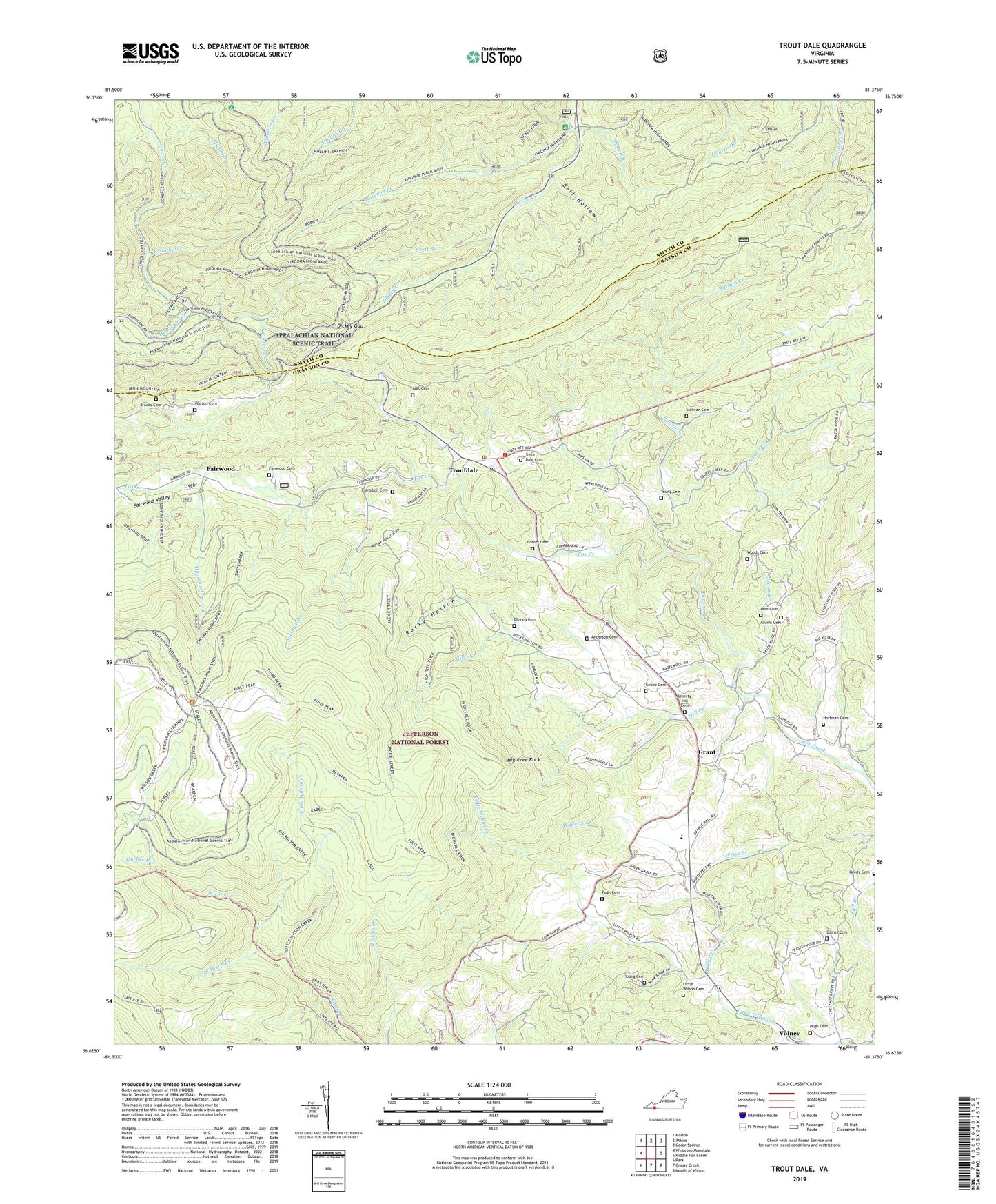
Trout Dale Virginia US Topo Map
Couldn't load pickup availability
Also explore the Trout Dale Forest Service Topo of this same quad for updated USFS data
2022 topographic map quadrangle Trout Dale in the state of Virginia. Scale: 1:24000. Based on the newly updated USGS 7.5' US Topo map series, this map is in the following counties: Grayson, Smyth. The map contains contour data, water features, and other items you are used to seeing on USGS maps, but also has updated roads and other features. This is the next generation of topographic maps. Printed on high-quality waterproof paper with UV fade-resistant inks.
Quads adjacent to this one:
West: Whitetop Mountain
Northwest: Marion
North: Atkins
Northeast: Cedar Springs
East: Middle Fox Creek
South: Grassy Creek
Southwest: Park
This map covers the same area as the classic USGS quad with code o36081f4.
Contains the following named places: Adams Cemetery, Anderson Cemetery, Bearpen Ridge, Bearpen Trail, Bell Hollow, Big Spring Ridge, Big Wilson Creek, Blevins Cemetery, Bobbys Ridge, Bobby's Trail, Bolt Cemetery, Brooks Cemetery, Brushy Butt, Campbell Cemetery, Comer Cemetery, Comers Creek Church, Comers Creek Trail, Dainel Cemetery, Dickey Gap, Dickey Ridge, Fairwood, Fairwood Cemetery, Fairwood Valley, First Peak, First Peak Trail, Fox Creek Church, Friendship Church, Grant, Green Ridge, Grubb Cemetery, Hickory Ridge, Hickory Ridge Trail, High Point, Hightree Rock, Hoffman Cemetery, Hurricane Campground, Hurricane Creek, Hurricane Creek Trail, Hutton Branch, Jones Knob, Laurel Creek, Laurel Creek Dam, Laurel Creek School, Liberty Hill Cemetery, Liberty Hill Church, Little Wilson Cemetery, Little Wilson Church, Little Wilson Creek, Little Wilson Creek Wilderness, Little Wilson School, Mill Creek, Mink Ridge, Mount Rogers National Recreation Area, Muddy Branch, Mullins Branch Trail, Opossum Creek, Pugh Cemetery, Quebec Branch, Raccoon Branch, Raccoon Branch Campground, Raccoon Branch Shelter, Raccoon Branch Wilderness, Razor Ridge Church, Razor Ridge School, Reedy Cemetery, Ripshin Creek, Rocky Hollow, Ross Cemetery, Scales Trail, Scott Branch, Second Peak, Sells Knob, Shanty Branch, Snake Den Ridge, Solomon Branch, Stone Mountain, Straight Mountain, Sugar Branch, Sullivan Cemetery, Switchback Trail, Third Peak, Third Peak Trail, Town of Troutdale, Trout Dale, Trout Dale Cemetery, Troutdale Community Volunteer Fire Department, Troutdale Post Office, Upper Sharp Knob, Volney, Wallen Creek, Watson Cemetery, Weiss Branch, Wilburn Branch, Wilson Creek District, Woods Cemetery, Young Cemetery, ZIP Code: 24378