MyTopo
Blaine Washington US Topo Map
Couldn't load pickup availability
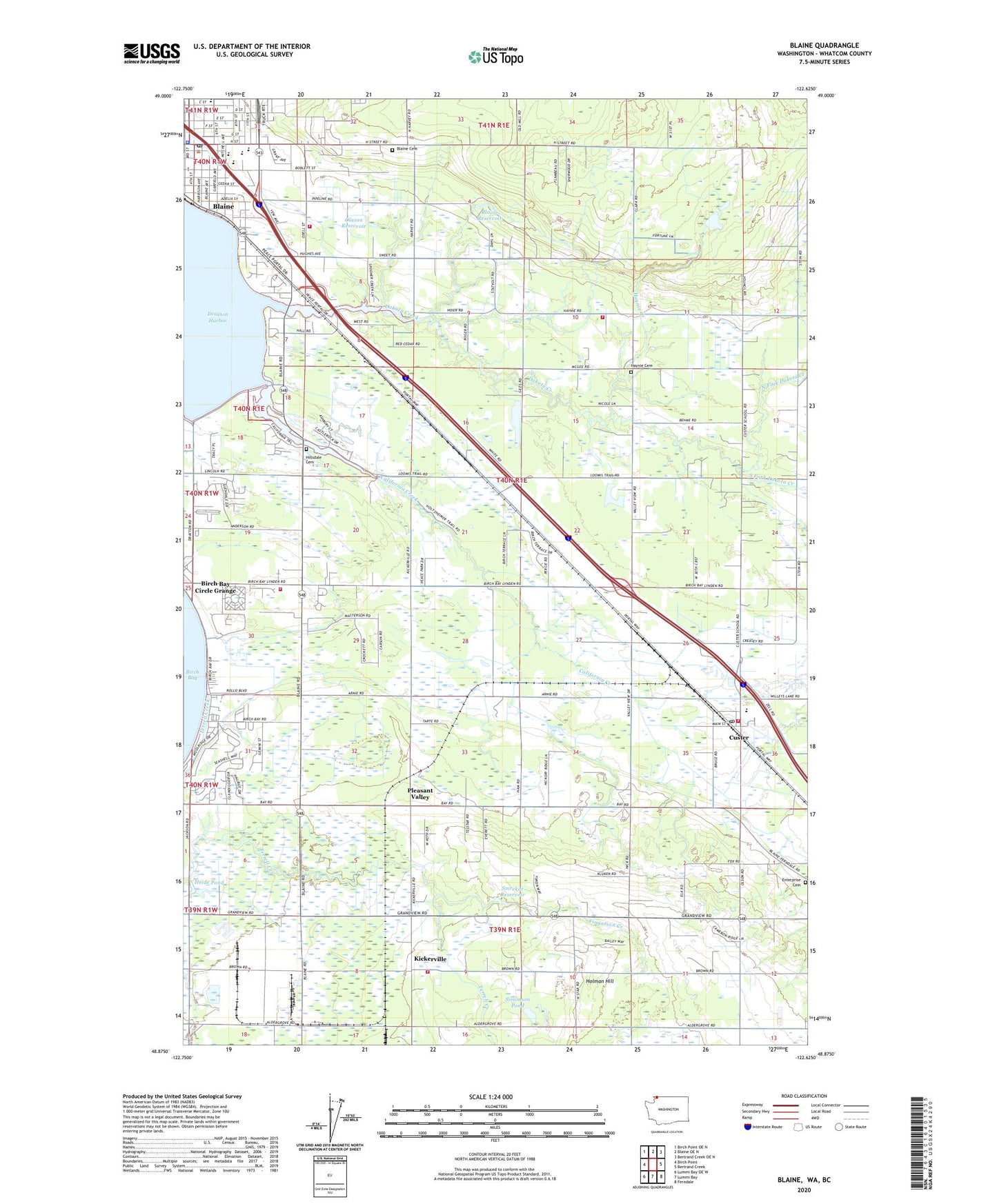
2023 topographic map quadrangle Blaine in the state of Washington. Scale: 1:24000. Based on the newly updated USGS 7.5' US Topo map series, this map is in the following counties: Whatcom. The map contains contour data, water features, and other items you are used to seeing on USGS maps, but also has updated roads and other features. This is the next generation of topographic maps. Printed on high-quality waterproof paper with UV fade-resistant inks.
Quads adjacent to this one:
West: Birch Point
Northwest: Birch Point OE N
North: Blaine OE N
Northeast: Bertrand Creek OE N
East: Bertrand Creek
Southeast: Ferndale
South: Lummi Bay
Southwest: Lummi Bay OE W
This map covers the same area as the classic USGS quad with code o48122h6.
Contains the following named places: A A Dairy, Aldergrove Farms, Bay Community Baptist Church, Baywood Mobile Home Park, Bel Air Village Trailer Court, Birch Bay, Birch Bay Bible Community Church, Birch Bay Circle Grange, Birch Bay Post Office, Birch Bay Resort Mobile Home Park, Blaine, Blaine Air Force Station, Blaine Cemetery, Blaine Christian Fellowship Church, Blaine City Hall, Blaine Elementary School, Blaine High School, Blaine Library, Blaine Middle School, Blaine Municipal Airport, Blaine Pit, Blaine Police Department, Blaine Post Office, Blaine Primary School, Blaine Reservoir, Blaine Reservoir Dam, Blaine School District 503 Office, California Creek, Cherry Point Refinery, Christ Community Church, Christ Episcopal Church, City of Blaine, Custer, Custer Census Designated Place, Custer Elementary School, Custer Post Office, Custer Substation, Custer United Methodist Church, Dakota Creek, Dakota Creek Golf Course, Edgewater Resort and Trailer Park, Enterprise Cemetery, Family Hill Dairy, Fingalson Creek, Grace Lutheran Church, Grandview Golf Course, Haynie, Haynie Cemetery, Haynie Community Hall, Haynie Creek, Haynie Grange, Heide Pond, Heide Pond Dam, Hillsdale, Hillsdale Cemetery, Holman Hill, KARI-AM (Blaine), Kickerville, Kingdom Hall of Jehovahs Witnesses, KLYN-FM (Lynden), Lake Terrell State Game Refuge, Lincoln Park, Loomis Trail Golf and Country Club, Montfort Park, North Bay Christ the King Community Church, North Fork Dakota Creek, North Star Quarry, North Whatcom Fire and Rescue Station 61 Blaine, North Whatcom Fire and Rescue Station 64 Custer, North Whatcom Fire and Rescue Station 65 Haynie, North Whatcom Fire Rescue Station 63 Birch Bay, Northwood Alliance Church, Olason Reservoir, Olason Reservoir Dam, Paul Dairy, Peace Arch Assembly of God Church, Plaza Mobile Home Park, Pleasant Valley, Pleasant Valley Dairy, Polaris Surface Mine, Puget Sound Energy Whitehorn Point Whitehorn Generating Station, Saint Anne Catholic Church, Semiahmoo Kids Kamp Daycare Center, Simonson Pond, Simonson Pond Dam, Skallman Park, Smrekar Reservoir, Smrekar Reservoir Dam, South Fork Dakota Creek, Stafholt Good Samaritan Center, Unitarian Free Church, United Church of Christ, Valley View Gravel Quarry, Whatcom County Fire District 7 Station 42 Brown Road, Zion Lutheran Church, ZIP Code: 98230