MyTopo
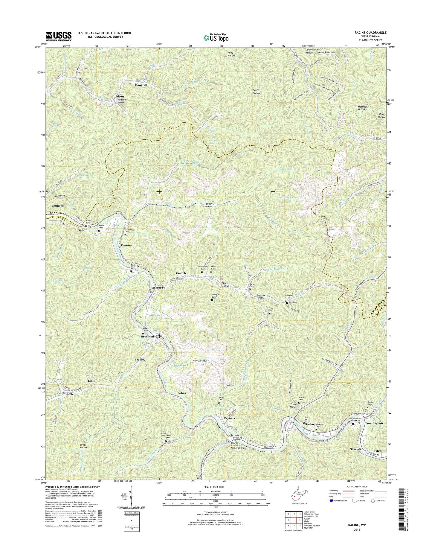
Racine West Virginia US Topo Map
Couldn't load pickup availability
2023 topographic map quadrangle Racine in the state of West Virginia. Scale: 1:24000. Based on the newly updated USGS 7.5' US Topo map series, this map is in the following counties: Boone, Kanawha. The map contains contour data, water features, and other items you are used to seeing on USGS maps, but also has updated roads and other features. This is the next generation of topographic maps. Printed on high-quality waterproof paper with UV fade-resistant inks.
Quads adjacent to this one:
West: Julian
Northwest: Alum Creek
North: Charleston West
Northeast: Charleston East
East: Belle
Southeast: Sylvester
South: Williams Mountain
Southwest: Madison
This map covers the same area as the classic USGS quad with code o38081b6.
Contains the following named places: Ashford, Ashford Church of God, Ashford Post Office, Ashford Rumble Elementary School, Barker Cemetery, Bloomingrose, Bloomingrose Post Office, Boone County Ambulance Authority 40, Bradley, Brier Branch, Brier Creek Tabernacle, Brush Creek, Brushton, Brushy Branch, Bull Creek, Burgess Hollow, Charles R Carrico Memorial Bridge, Coal River Branch Library, Costa Post Office, Courtney Cemetery, Curtis Branch, Curtis Branch Dam, Dartmont, Davis Creek Camping Area, Davis Creek Picnic Area, Drawdy Creek, Drawdy Falls Roadside Park, Dry Branch, Dungriff, Easly, Eden, Evans Cemetery, Falling Rock Fork, Fauber Cemetery, Ferneys Branch, First Baptist Church of Racine, Foster Cemetery, Foster Hollow, Grippe, Holstein Cemetery, Holstein Hollow, Honeycamp Fork, Indian Creek, Indian Creek Cemetery, Javins Cemetery, Johns, Kinder Cemetery, Kirk Cemetery, Left Fork Brier Creek, Left Fork Bull Creek, Leon Memorial Tabernacle, Lick Creek, Lico, Little Rich Fork, Log Town Hollow Picnic Area, Loggy Hollow, Longs Hollow, Lower Drawdy School, Mahone Chapel, Mary Fork, McDerment Cemetery, Meadow Fork Brier Creek, Mechanics and Miners Cemetery, Mikes Run, Mill Branch, Morris Cemetery, Nellis, Nellis Elementary School, Nellis Post Office, Olcott, Perry Cemetery, Peytona, Peytona Bridge, Peytona Church of Christ, Peytona Grade School, Peytona Post Office, Porter Cemetery, Price Cemetery, Racine, Racine Census Designated Place, Racine Methodist Church, Racine Post Office, Racine Volunteer Fire Department, Racine-Peytona Elementary School, Rich Fork, Road Fork, Roundbottom Creek, Rumble, Sentz Lick Branch, Sharlow, Short Creek, Snodgrass Cemetery, Spruce Fork, Sugarcamp Fork, Thomas Branch, Toneys Branch, Wade Cemetery, Walker Creek, Walker Hollow, Welch Branch, White Oak Branch, White Oak Creek, Workman Cemetery, ZIP Codes: 25009, 25051, 25142, 25165