MyTopo
Mallory West Virginia US Topo Map
Couldn't load pickup availability
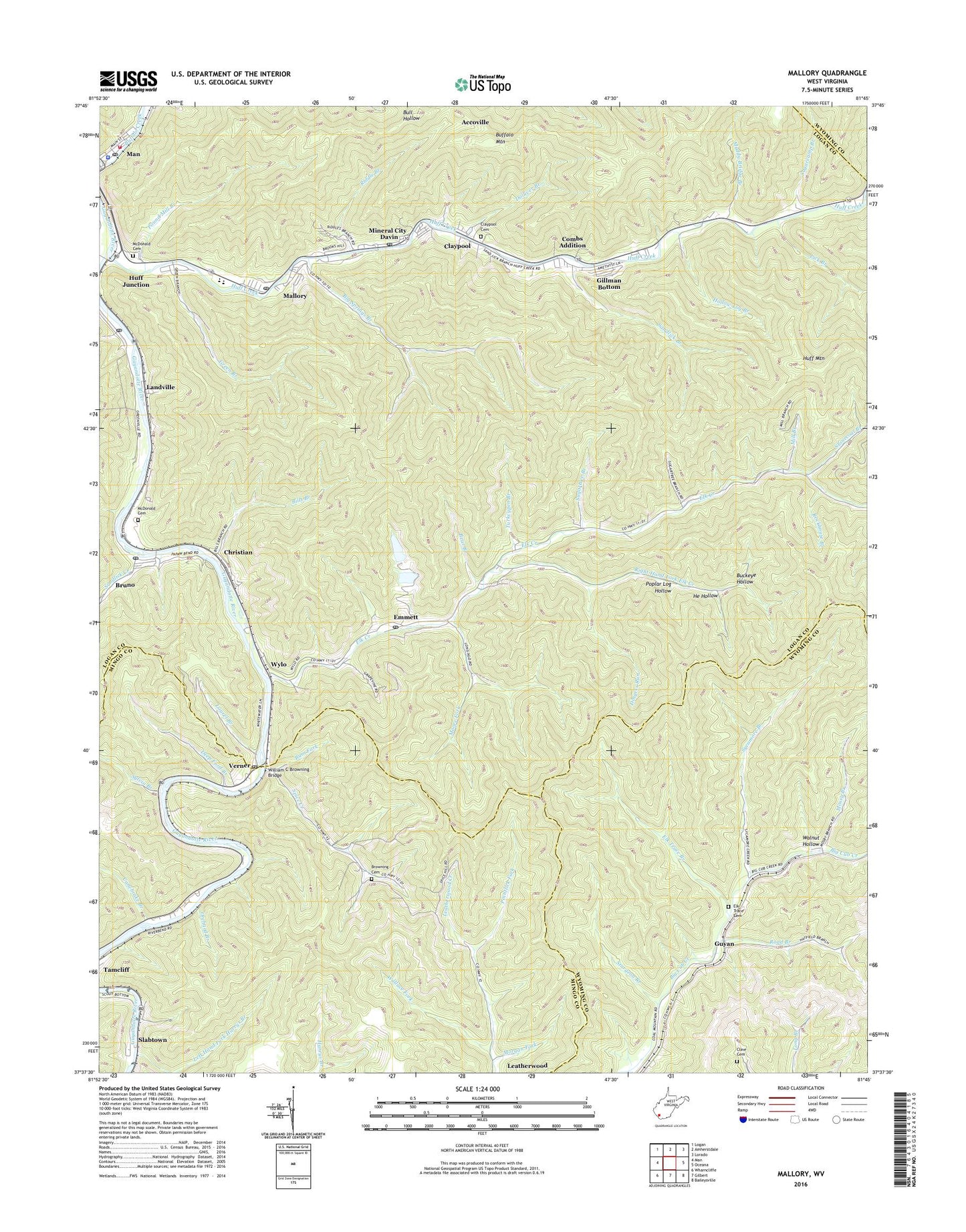
2023 topographic map quadrangle Mallory in the state of West Virginia. Scale: 1:24000. Based on the newly updated USGS 7.5' US Topo map series, this map is in the following counties: Logan, Mingo, Wyoming. The map contains contour data, water features, and other items you are used to seeing on USGS maps, but also has updated roads and other features. This is the next generation of topographic maps. Printed on high-quality waterproof paper with UV fade-resistant inks.
Quads adjacent to this one:
West: Man
Northwest: Logan
North: Amherstdale
Northeast: Lorado
East: Oceana
Southeast: Baileysville
South: Gilbert
Southwest: Wharncliffe
This map covers the same area as the classic USGS quad with code o37081f7.
Contains the following named places: Bear Branch, Big Springs Branch, Bills Branch, Browning Cemetery, Bruno, Bruno Census Designated Place, Bruno Post Office, Buckeye Hollow, Bum Fork, Canebrake Branch, Christian, Christian Branch, Christian Elementary School, Claypool, Claypool Cemetery, Cline Cemetery, Combs Addition, Community Church, Davin, Davin Post Office, Deep Ford Branch, Dingess Run, Dolliver Branch, Eastern District, Elk Creek, Elk Trace Branch, Elk Trace Cemetery, Emanuel Church, Emmett, Emmett Post Office, Gillman Bottom, Green Branch, Greenville, Greenville Census Designated Place, Guyan, Harrys Branch, He Hollow, Hollow Log Branch, Huff Creek, Huff Junction, Hunt Post Office, Landville, Laurel Branch, Lick Branch, Mallory, Mallory Census Designated Place, Mallory Elementary School, Mallory Post Office, Man Appalachian Regional Hospital, Man Elementary School, Man Junior High School, Man Middle School, Man Police Department, Man Post Office, Man Volunteer Fire Department, McDonald Cemetery, Mill Branch, Mineral City, Moore Fork, Morgan Fork, Mossy Branch, Mountain Mart Village Shopping Center, Muddy Bridge Branch, Oldhouse Branch, Orchard Branch, Pilgrim Rest Church, Pointlick Fork, Poplar Log Hollow, Pound Mill Branch, Riddle Branch, Right Hand Fork Elk Creek, Riverview Church, Road Branch, Rockhouse Branch, Sandlick Branch, Sandlick Church, Sandlick Creek, Slabtown, Spice Creek, Stonecoal Branch, Sturgeon Branch, Sugarcamp Branch, Sugartree Branch, Sycamore Branch, Sylvia Branch, The Church of the Timber, Triadelphia Country Club, Triadelphia Country Club Golf Course, Turkeypen Branch, Verner, Verner Post Office, Wallace Fork, Walnut Hollow, William C Browning Bridge, Wylo, ZIP Codes: 24823, 24882, 25611, 25617, 25634, 25650