MyTopo
Montgomery West Virginia US Topo Map
Couldn't load pickup availability
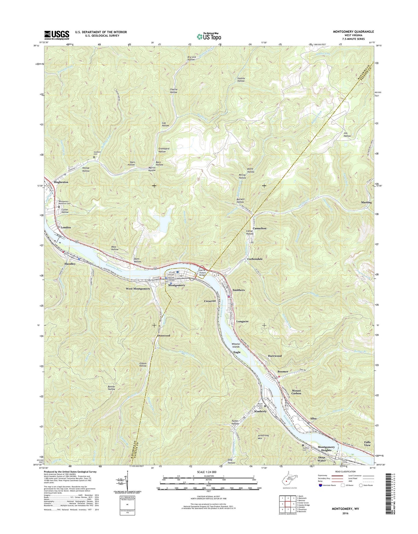
2023 topographic map quadrangle Montgomery in the state of West Virginia. Scale: 1:24000. Based on the newly updated USGS 7.5' US Topo map series, this map is in the following counties: Kanawha, Fayette. The map contains contour data, water features, and other items you are used to seeing on USGS maps, but also has updated roads and other features. This is the next generation of topographic maps. Printed on high-quality waterproof paper with UV fade-resistant inks.
Quads adjacent to this one:
West: Cedar Grove
Northwest: Quick
North: Mammoth
Northeast: Bentree
East: Gauley Bridge
Southeast: Beckwith
South: Powellton
Southwest: Eskdale
This map covers the same area as the classic USGS quad with code o38081b3.
Contains the following named places: Alloy, Alloy Heliport, Alloy Post Office, Armstrong Creek, Barn Hollow, Blake Branch, Boomer, Boomer Branch, Boomer Census Designated Place, Boomer Christian Academy, Boomer Post Office, Boomer Volunteer Fire Department, Bufflick Fork, Bullpush Fork, Burnett Hollow, Cannelton, Cannelton Post Office, Canoe Hollow, Carbondale, Charlie Hollow, City of Montgomery, City of Smithers, Cob Hollow, Crescent, Custer Hollow, Dark Hollow, Deep Water, Donwood, Dry Lick Hollow, Dunn Hollow, Eagle, Eagle Church, Earl M Vickers Bridge, Falls View Census Designated Place, Falls View Elementary School, Fayette County Sheriff's Office - Smithers Detachment, Fishhook Fork, Fitzgerald Branch, Fourmile Fork, Gibson Hollow, Goodwin Cemetery, Grant School, Graveyard Hollow, Guthrie Cemetery, Handley, Handley Community Volunteer Fire Department, Handley Police Department, Handley Post Office, Harewood, Heslop Hollow, Horse Fork, Huddleston Memorial Church, Hughes Creek, Hughes Creek Church, Hughes Creek Community Church, Hugheston, Hugheston Post Office, Jan - Care Ambulance Service Montgomery, Jarrett Branch, Kimberly, Kimberly Census Designated Place, Kimberly Elementary School, Kimberly Post Office, London, London Lock, London Locks and Dam, London Post Office, Longacre, Loop Creek, Lower Creek, Lynch Fork, Martin Hollow, Marting, McCoy Hollow, Montgomery, Montgomery Fire Department, Montgomery General Hospital, Montgomery Heights, Montgomery Memorial Cemetery, Montgomery Middle School, Montgomery Police Department, Montgomery Post Office, Montgomery Public Library, Morris Creek, Mount Carbon, Mount Carbon Cemetery, Mount Carbon Census Designated Place, Mount Carbon Post Office, Mount Zion Church, Oakland, Oakland School, Riffle Hollow, Saint Anthonys Church, School Number 4, Schuyler Fork, Shadrick Fork, Sixmile Fork, Sixmile Hollow, Smithers, Smithers Creek, Smithers Police Department, Smithers Post Office, Smithers Volunteer Fire Department, Staten Run, Stop Hollow, Sugarcamp Branch, Threemile Creek, Town of Handley, Tucker Hollow, Twomile Creek, Upper Creek, Valley Elementary School, Valley High School, West Hollow, West Montgomery, West Virginia Institute of Technology, West Virginia University Institute of Technology Campus Police Department, Wheeler Islands, WMON-AM (Montgomery), Youngs Branch, ZIP Codes: 25031, 25036, 25039, 25102, 25110, 25126, 25136, 25139, 25156, 25186