MyTopo
Mount Alto West Virginia US Topo Map
Couldn't load pickup availability
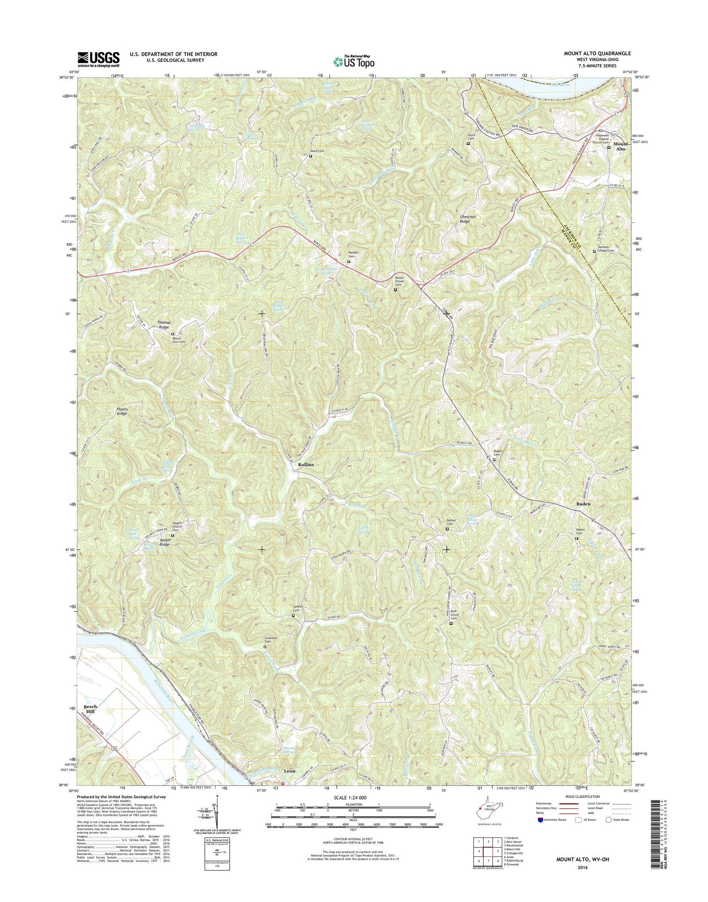
2023 topographic map quadrangle Mount Alto in the state of West Virginia. Scale: 1:24000. Based on the newly updated USGS 7.5' US Topo map series, this map is in the following counties: Mason, Jackson, Meigs. The map contains contour data, water features, and other items you are used to seeing on USGS maps, but also has updated roads and other features. This is the next generation of topographic maps. Printed on high-quality waterproof paper with UV fade-resistant inks.
Quads adjacent to this one:
West: Beech Hill
North: New Haven
Northeast: Ravenswood
East: Cottageville
Southeast: Elmwood
South: Robertsburg
Southwest: Arlee
This map covers the same area as the classic USGS quad with code o38081g8.
Contains the following named places: Ash, Baden, Baden Baptist Church, Baden Cemetery, Baden Presbyterian Church, Barnett Fork, Bearwallow School, Beech Hill Station, Bethel Cemetery, Bethel Church, Bug Run, Bug Run School, Carl McDale Spring, Chestnut, Chestnut Ridge, Cleon Cadle Spring, Clifford Vickers Spring, Cologne District, Cooper District, Cooper Fork, Davies Grove Church, Dowell Spring, Everett Keefer Spring, Excelsior School, Forked Pine School, Gill School, Gill Spring, Greenlee Cemetery, Guy Midturn Spring, Harmony School, Harold Sayre Spring, Harvey Chapel, Hill School, Homer Peck Spring, Hopedale School, Hopewell Baptist Church Cemetery, Hopewell Church, Howell School, Huff Run, Huff School, Jackson Chapel Cemetery, Jenkins Cemetery, Kings Branch, Leo Roush Spring, Leon, Leon Post Office, Leon Volunteer Fire Department, Lick Fork, Little Mill Creek, Maupin Landing, Morgan Cemetery, Mount Alto, Mount Alto Post Office, Mount Flower Cemetery, Mount Hebron Church, Mount Moriah Church, Mount Olive Church, Mount Zion Cemetery, Mount Zion Church, Mountain Flower School, Oscar Weigand Spring, Otis Randolph Spring, Pine Grove Cemetery, Pine Grove Church, Plants Ridge, Plants Run, Pond Branch, Red Mud School, Roanoke School, Rollins, Rollins Dam Number One, Rollins Lake Number Two Dam, Rollins Spring, Runion Spring, Sayre Cemetery, Shiloh Church, Tenmile Creek, Thirteenmile Creek, Thomas Ridge, Thomas School, Toms Run, Union School, Ward Cemetery, Wood, Wood School, Yauger Church, Yauger Church Cemetery, Yauger Ridge, Yeager School, ZIP Code: 25264