MyTopo
Ranger West Virginia US Topo Map
Couldn't load pickup availability
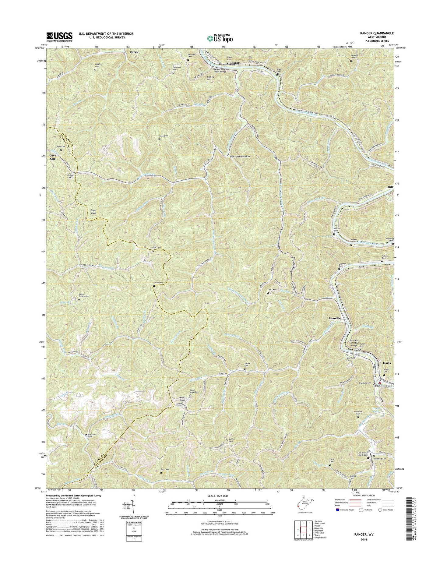
2023 topographic map quadrangle Ranger in the state of West Virginia. Scale: 1:24000. Based on the newly updated USGS 7.5' US Topo map series, this map is in the following counties: Lincoln, Wayne. The map contains contour data, water features, and other items you are used to seeing on USGS maps, but also has updated roads and other features. This is the next generation of topographic maps. Printed on high-quality waterproof paper with UV fade-resistant inks.
Quads adjacent to this one:
West: Kiahsville
Northwest: Nestlow
North: Branchland
Northeast: Hager
East: Big Creek
Southeast: Chapmanville
South: Trace
Southwest: Wilsondale
This map covers the same area as the classic USGS quad with code o38082a2.
Contains the following named places: Aarons Creek, Aarons Creek Church, Adkins Cemetery, Atenville, Atenville Church, Atenville Elementary School, Baker Cemetery, Bearwallow Branch, Beaver Pond Branch, Bee Branch, Bells Fishing Lake Dam, Big Branch, Big Branch School, Big Harts Creek, Big Laurel School, Big Ugly Creek, Bolin, Brewster Cemetery, Bridge Branch, Browning Cemetery, Browns Branch, Brumfield Cemetery, Bryant Fork, Caney Branch, Chapman Church, Coal Branch, Coal Branch Church, Coal Branch Church Cemetery, Coal Branch School, Cove Knob, Curry Branch, Curry Cemetery, Cuzzie, Cuzzie School, Dalton Cemetery, Dalton Fork, Dean Cemetery, District 2, Dry Run, Dyer Cemetery, East Fork Church, East Fork Fourteenmile Creek, Eden Park, Fourteen, Fourteenmile Creek, Frances Creek, Frye Cemetery, Gartin Fork, Gartin Knob Lookout Tower, Guyan Church, Hamilton Creek, Hampton Creek, Harless Branch, Hartland Coal Haul Bridge, Harts, Harts Census Designated Place, Harts Creek Bridge, Harts High School, Harts Intermediate School, Harts Pond, Harts Post Office, Harts Primary School, Harts Volunteer Fire Department, Harvey Fork, Hatfield Cemetery, Jones Cemeteries, Lambert Cemetery, Lattin, Laurel Fork, Lick Branch, Lick Fork, Lincoln Emergency Medical Services Harts Substation, Little Harts Church, Little Harts Creek, Mann Knob, Mann Knob Cemetery, Mann Knob School, Maynard Cemetery, McCoy Cemetery, Montana Church, Mountain Home Church, Mudlick Branch, Mullins Cemetery, Murphy Cemetery, Nelson Cemetery, Nelson Fork, New Salem Church, Orchard Branch School, Pigpen Branch, Plum Branch, Pretty Branch, Ranger, Ranger Beam Span Bridge, Ranger Elementary School, Ranger Post Office, Road Fork School, Robinson Cemetery, Rollem Fork, Sandlick Branch, Saunders Cemetery, Short Bend Fork, Short Bend Hollow, Sias Cemetery, Sias School, Spry Cemetery, Steer Fork, Sulphur Spring Fork, Tomblin Branch, Trough Fork School, Upper Tenmile Church, Vance Branch, Webb Cemetery, West Fork Big Harts Creek, Wewanta, Witcher Fork, Workman Cemetery, ZIP Code: 25557