MyTopo
Ravenswood West Virginia US Topo Map
Couldn't load pickup availability
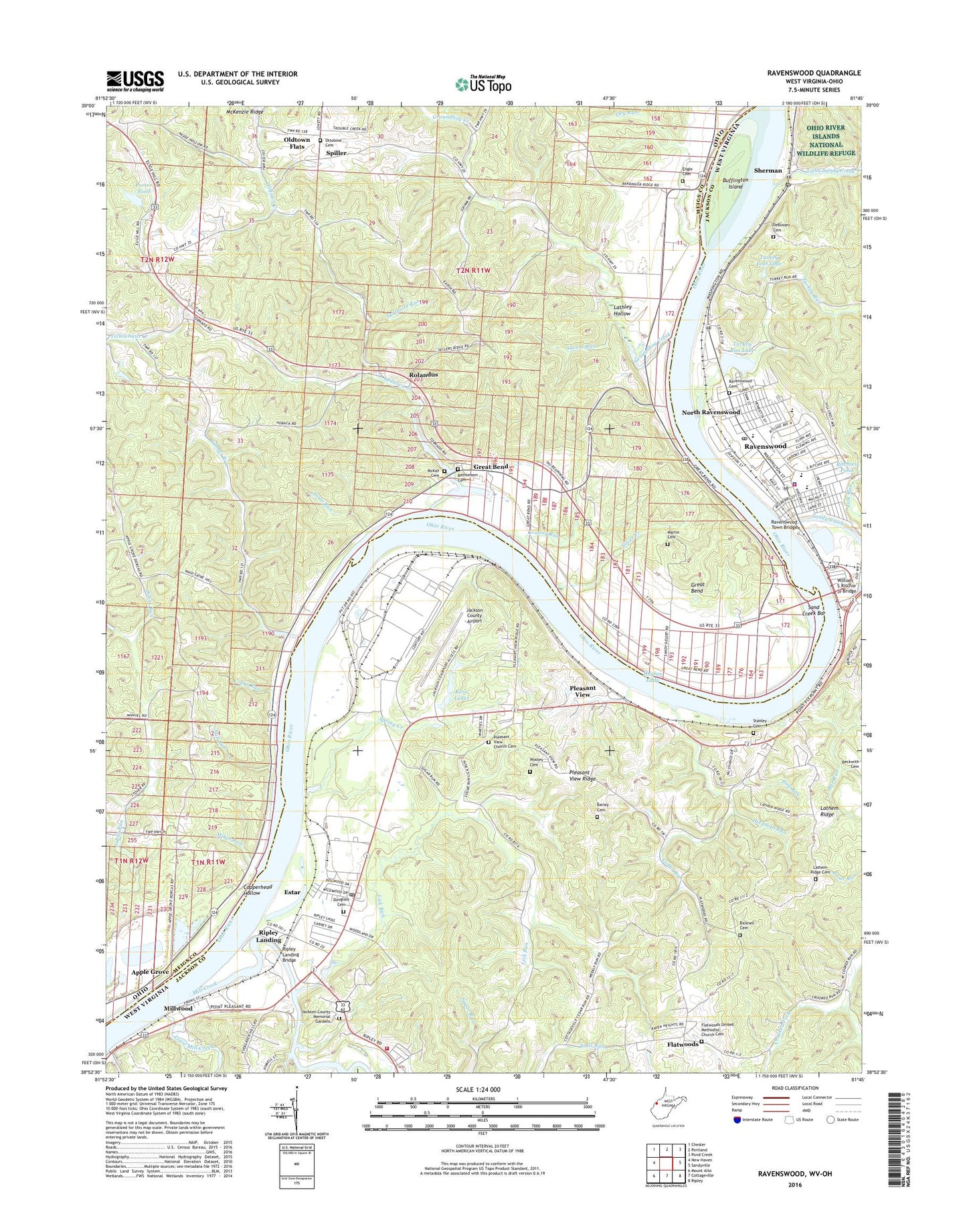
2019 topographic map quadrangle Ravenswood in the states of Ohio, West Virginia. Scale: 1:24000. Based on the newly updated USGS 7.5' US Topo map series, this map is in the following counties: Jackson, Meigs. The map contains contour data, water features, and other items you are used to seeing on USGS maps, but also has updated roads and other features. This is the next generation of topographic maps. Printed on high-quality waterproof paper with UV fade-resistant inks.
Quads adjacent to this one:
West: New Haven
Northwest: Chester
North: Portland
Northeast: Pond Creek
East: Sandyville
Southeast: Ripley
South: Cottageville
Southwest: Mount Alto
Contains the following named places: Adams School, Alcan Rolled Products Ambulance, Apple Grove, Applegrove Post Office, Bar Run, Bethlehem Baptist Church, Bethlehem Cemetery, Bicknell Cemetery, Buffington Island, Byerle Cemetery, Cedar Run, Cedar Run Church, Cedar Run School, Church of Christ, City of Ravenswood, Clenicus School, Cooks Run, Copperhead Hollow, Cottageville Volunteer Fire Department, Crows Landing, DeBussey Cemetery, Douglass Cemetery, Dows Landing, Dry Run, Dyes Landing, Engle Cemetery, Estar, Fairview Church, Fairview School, Faith Bible Church, First Christian Church, Flatwoods, Flatwoods United Methodist Church Cemetery, Grace Episcopal Church, Granny Run, Granny Run Post Light, Great Bend, Great Bend Church, Greatbend Post Office, Groundhog Creek, Halls Landing, Henry J Kaiser Elementary School, Heritage Christian Academy, Hills Crossing, Hopedale School, Hughes Eddy, Jackson County Airport, Jackson County Emergency Medical Services Station 401, Jackson County Memorial Gardens, James Hall Landing, Kera Lakes, Keraland Recreation Area, Latham Ridge School, Lathem Ridge, Lathem Ridge Cemetery, Lathley Hollow, Lick Run, Lick Run School, Little Mill Creek, Little Sandy Creek, Lock and Dam Number 22, Lock and Dam Number 23, Lock Number 22, Martin Cemetery, McClintocks Landing, McKay Cemetery, McKays Landing, Mikes Run, Mill Creek, Mill Landing, Mill Run, Millwood, Millwood Post Office, Morse Chapel Methodist Church, North Ravenswood, North United Methodist Church, Oldtown Creek, Oldtown Flats, Ottobine Cemetery, Our Saviour Evangelical Lutheran Church, Painters Landing, Pickens Landing, Pleasant View, Pleasant View Cemetery, Pleasant View Church, Pleasant View Ridge, Pole Run, Porter Pond, Porter Pond Dam, Praise Cathedral, Ravenswood, Ravenswood Cemetery, Ravenswood Ferry, Ravenswood High School, Ravenswood Middle School, Ravenswood Plaza Shopping Center, Ravenswood Police Department, Ravenswood Post Office, Ravenswood Seaplane Base, Ravenswood Town Bridge, Ravenswood Volunteer Fire Department, Ravenswood Works, Ripley Landing, Ripley Landing Bridge, Ritchies Pond, Rolandus, Rolandus Post Office, Rouses Landing, Sand Creek Bar, Sandy Creek, Savers Run, Saxon, Saxon Post Office, Sayres Landing, School House, Second Baptist Church, Sherman, Sherman Post Office, Silver Creek, Skidmore Run, Spiller, Spiller Post Office, Spring Creek, Stanley Cemetery, Stedman Run, Tanner Run, Toms Run, Towhead Island, Township of Lebanon, Turkey Foot Lake, Turkey Run, Turkey Run Lake, Turkey Run Lake Dam, Turkey Run Lake Wildlife Management Area, Turkey Run School, Ulric, Ulric Post Office, William S Ritchie Jr Bridge, Williamson Landing, Willow Grove, WMOV-AM (Ravenswood), Wooley Cemetery, ZIP Codes: 25262, 45770