MyTopo
Welch West Virginia US Topo Map
Couldn't load pickup availability
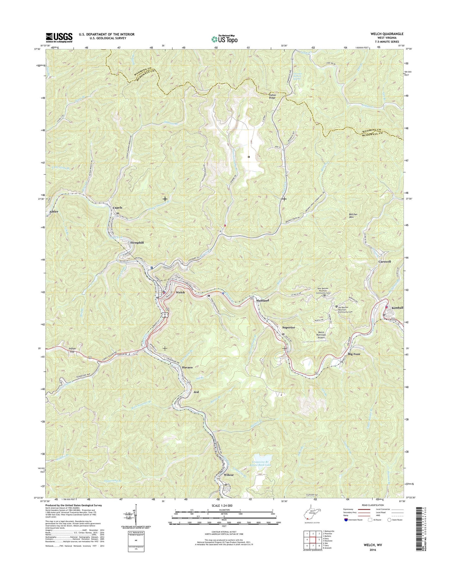
2023 topographic map quadrangle Welch in the state of West Virginia. Scale: 1:24000. Based on the newly updated USGS 7.5' US Topo map series, this map is in the following counties: McDowell, Wyoming. The map contains contour data, water features, and other items you are used to seeing on USGS maps, but also has updated roads and other features. This is the next generation of topographic maps. Printed on high-quality waterproof paper with UV fade-resistant inks.
Quads adjacent to this one:
West: Davy
Northwest: Baileysville
North: Pineville
Northeast: Mullens
East: Keystone
Southeast: Anawalt
South: Gary
Southwest: War
This map covers the same area as the classic USGS quad with code o37081d5.
Contains the following named places: Anderson Memorial Presbyterian Chapel, Antler, Belcher Mountain, Big Branch, Big Four, Browns Creek, Browns Creek District, Browns Creek District High School, Capels, Capels Post Office, Career and Technology Center, Carswell, Church of Christ, Church of God, City of Welch, Clarence Stewart Spring, Community Church, Court Street Methodist Church, Dunbar High School, Ebenezer Presbyterian Church, Elkhorn Church, Elkhorn Creek, Federal Correctional Institution McDowell, First Baptist Church, First Methodist Church, Fort Branch, Grace Hospital, Grapevine Branch, Grapevine Branch Refuse and Impoundment Dam, Grapevine Branch Refuse Bank Lake, Harris Branch, Havaco, Hemphill, Hemphill-Capels School, Houston Methodist Church, Indian Gap, Indian Ridge, Jan - Care Ambulance Service of Guardian Angel, Jed, Jed Branch, Kimball, Kimball Police Department, Kimball Town Hall, Kimball Volunteer Fire Department, Laurel Branch, Laurel Branch Dam, Lick Branch, Little Cub Branch, Little Indian Creek, Maitland, Maitland-Superior Junior High School, Marquee Cinemas McDowell 3, McDowell County Adult Learning Center, Mcdowell County Alternative School, McDowell County Courthouse, McDowell County Emergency Ambulance Authority Station 2, McDowell County Jail, McDowell County Public Library, McDowell County Sheriff's Office, McDowell County Vocational School, McDowell Volunteer Fire Department, Meetinghouse Branch, Mill Creek, Mitchell Branch, Mod Branch, Mod Branch Dam Number Five, Mod Branch Dam Number Four, Mod Branch Dam Number One, Mod Branch Dam Number Three, Mod Branch Dam Number Two, Mount Nebo Baptist Church, Mount View High School, Mount View School, Nazarene Christian Academy, New Belcher Mountain Community Cemetery, North Welch Church, Old Belcher Mountain Community Cemetery, Peters Branch, Phoenix Center Alternative School, Puncheoncamp Branch, Rock Narrows Branch, Rockhouse Branch, Saint James Baptist Church, Shannon Branch, Shiloh Church, Simms African Methodist Episcopal Church, Stevens Clinic Hospital, Stevens Correctional Center - McDowell County Corrections - Stevens Facility, Stevens Correctional Center - McDowell County Corrections - Welch Facility, Sugarcamp Branch, Superior, Superior Post Office, Temple Emanuel, Town of Kimball, Trail Fork, Upper Belcher Branch, Upper Shannon Branch, WELC-AM (Welch), WELC-FM (Welch), Welch, Welch City Hall, Welch Community Hospital, Welch Elementary School, Welch Middle School, Welch Municipal Airport, Welch Pentecostal Holiness Church, Welch Police Department, Welch Post Office, Welch Volunteer Fire Department, West Virginia State Police Troop 6 - Welch Detachment, West Welch Church of God, Wilcoe, Wilcoe Post Office, WXEE-AM (Welch), Yerba, ZIP Codes: 24801, 24853