MyTopo
Weston West Virginia US Topo Map
Couldn't load pickup availability
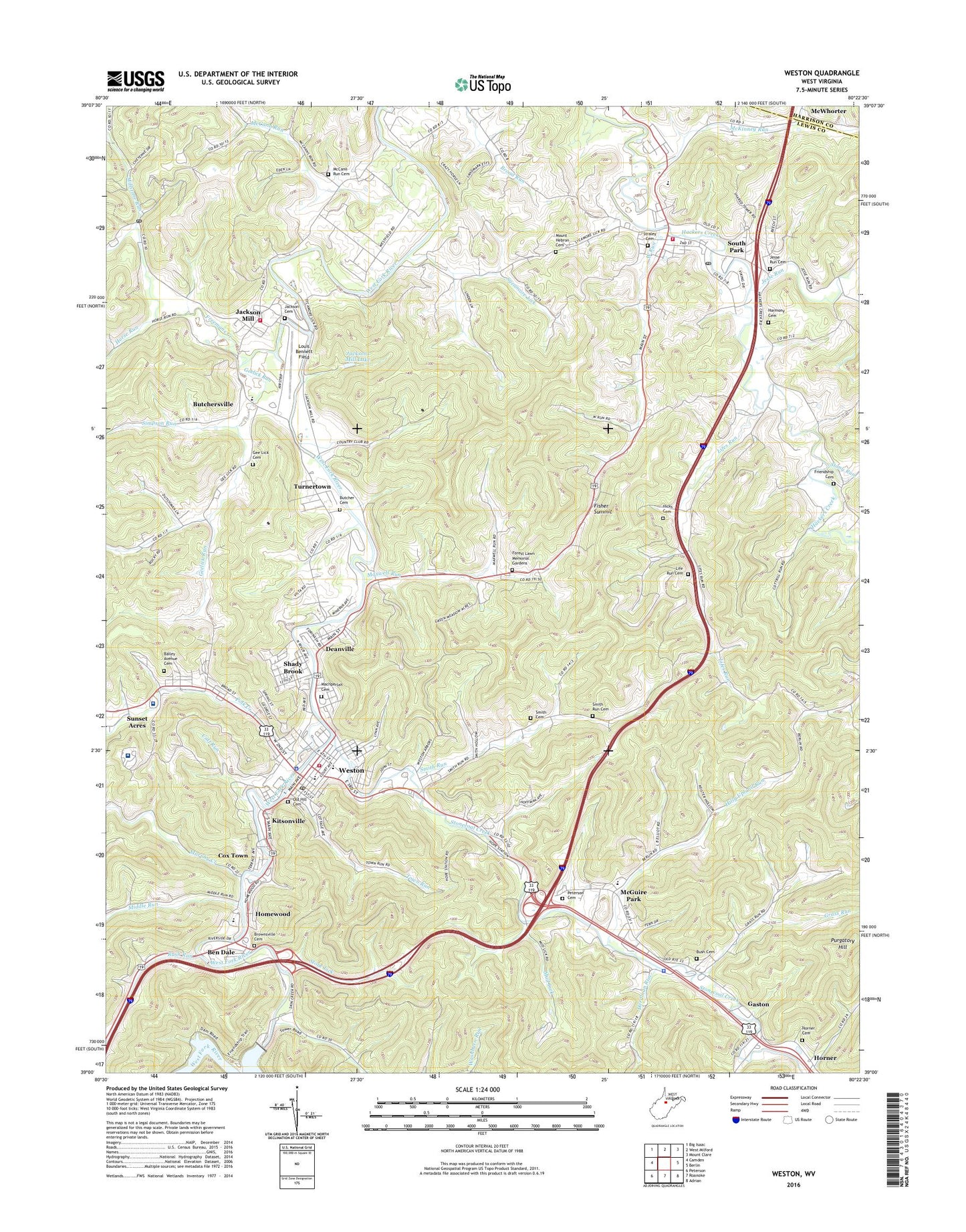
2023 topographic map quadrangle Weston in the state of West Virginia. Scale: 1:24000. Based on the newly updated USGS 7.5' US Topo map series, this map is in the following counties: Lewis, Harrison. The map contains contour data, water features, and other items you are used to seeing on USGS maps, but also has updated roads and other features. This is the next generation of topographic maps. Printed on high-quality waterproof paper with UV fade-resistant inks.
Quads adjacent to this one:
West: Camden
Northwest: Big Isaac
North: West Milford
Northeast: Mount Clare
East: Berlin
Southeast: Adrian
South: Roanoke
Southwest: Peterson
This map covers the same area as the classic USGS quad with code o39080a4.
Contains the following named places: All Faith Chapel, Bailey Avenue Cemetery, Ben Dale, Ben Dale School, Bendale Dam, Bendale Lake, Bendale United Methodist Church, Bible Deliverance Tabernacle, Broad Street United Methodist Church, Brownsville, Brownsville Cemetery, Buck Hill, Bush Cemetery, Butcher Cemetery, Butchersville, Calf Run, Church of Christ, Church of the Nazarene, Circle Heights, City Hospital, City of Weston, Clark Chapel, Cox Town, Deanville, Deerfield Country Club, Deerfield Country Club Golf Course, Dolan Trailer Park, Donlan Heights, Edgewood, Fairview School, Fairview United Methodist Church, First Baptist Church, First Methodist Episcopal Church, Fisher Hill, Fisher Summit, Forest Lawn Memorial Gardens, Freedom Baptist Church, Freemans Creek, Freemans Creek School, Friendship Cemetery, Garton Plaza Shopping Center, Garton Village, Gaston, Gaston Manor, Gee Lick Cemetery, Gee Lick United Methodist Church, Geelick Run, Grass Run, Grass Run School, Hackers Creek-Skin Creek District, Haleville, Haleville Full Gospel Church, Haleville School, Haleville Union Mission Church, Hall Addition, Hall Trailer Park, Harmony Cemetery, Harmony Church, Herdman Run, Hickory Hills, Hicks Cemetery, Hilly Upland Run, Homeland, Homewood, Horner, Horner Cemetery, Horner School, Horse Run, Jackson Acres, Jackson Cemetery, Jackson Heights, Jackson Mill, Jackson Mill Census Designated Place, Jacksons Mill, Jacksons Mill Baptist Church, Jacksons Mill Dam, Jacksons Mill Lake, Jacksons Mill State 4-H Camp, Jackson's Mill Volunteer Fire Department, Jane Lew, Jane Lew Elementary School, Jane Lew Post Office, Jane Lew Volunteer Fire Department, Jesse Run, Kitsonville, Kitsonville Public School, Lewis County Christian School, Lewis County Courthouse, Lewis County High School, Lewis County Industrial Park, Lewis County Jail, Lewis County Sheriff's Office, Life Run Cemetery, Lifes Run, Lightburn Acres, Los Anglin, Louis Bennett Field, Louis Bennett Public Library, Lower Geelick School, Lower Jesse Run School, Mace Addition, Machperlah Cemetery, Main Avenue Presbyterian Church, Main Avenue United Methodist Church, Market Place Shopping Center, Maxwell Run, McCann Run, McCann Run Cemetery, McCann Run United Methodist Church, McCann School, McGary, McGuire Park, McKinney Run, Memorial Methodist Church, Message of Light Tabernacle, Middle Run, Millstone Run, Mount Hebron Cemetery, Mount Hebron United Methodist Church, Mud Lick, Murphy Creek, New Life Southern Baptist Church, Norris School, Old Hill Cemetery, Outreach Christian Academy, Outreach Christian School, Park Plaza Shopping Center, Peterson Cemetery, Peterson Central Elementary School, Peterson-Central Elementary School, Pinecrest Addition, Pleasant Day Child Development Center, Polk Creek, Polk Creek Elementary School, Purgatory Hill, Quiet Dale, Riverview Heights, Robert L Bland Middle School, Rush Run, Saint Patrick Catholic Church, Saint Patrick School, Saint Paul Episcopal Church, Saint Pauls African Methodist Episcopal Church, Sauls Run, Shady Brook, Shadybrook Primary Center, Simpson Run, Smith Cemetery, Smith Run, Smith Run Cemetery, Smith Run Church, Smith Run School, Smith Village, South Park, South Park Trailer Park, Stone Lick, Stonecoal Creek, Stonecoal United Methodist Church, Stonewall Jackson Dam, Stonewall Jackson Memorial Hospital, Stony Run, Straley Addition, Straley Cemetery, Sunset Acres, Sycamore Lick, Town of Jane Lew, Town Run, Trefz Horse Farm Show Ring, Turnertown, Turnertown Census Designated Place, Upper Geelick School, Valley Chapel, Valley Chapel Post Office, Valley Chapel United Methodist Church, Washburn Run, Waugh School, WDTV-TV (Weston), West Run, West Virginia Department of Highways District 7 Shop, West Virginia Museum of American Glass, West Virginia State Police Troop 3 - Weston Detachment, Westfield, Weston, Weston - Lewis County Emergency Ambulance Service Authority Company 8, Weston Arbors, Weston Central Elementary School, Weston City Hall, Weston City Park, Weston Colored School, Weston Dam, Weston Downtown Historic District, Weston General Hospital, Weston High School, Weston Manor, Weston Police Department, Weston Post Office, Weston State Hospital, Weston United Brethren Church, Weston Volunteer Fire Department, WHAW-AM (Weston), William R Sharpe Jr Hospital, William R Sharpe Junior Hospital, Woodland Addition, Word of Life Ministries, WSSN-FM (Weston), ZIP Code: 26378