MyTopo
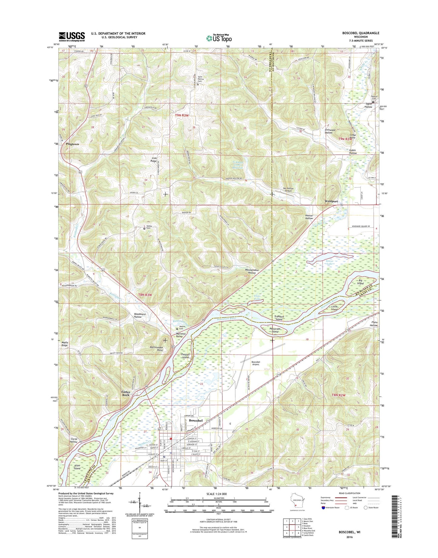
Boscobel Wisconsin US Topo Map
Couldn't load pickup availability
2018 topographic map quadrangle Boscobel in the state of Wisconsin. Scale: 1:24000. Based on the newly updated USGS 7.5' US Topo map series, this map is in the following counties: Crawford, Grant, Richland. The map contains contour data, water features, and other items you are used to seeing on USGS maps, but also has updated roads and other features. This is the next generation of topographic maps. Printed on high-quality waterproof paper with UV fade-resistant inks.
Quads adjacent to this one:
West: Steuben
Northwest: Gays Mills
North: Mount Zion
Northeast: Boaz
East: Blue River
Southeast: Castle Rock
South: Long Hollow
Southwest: Wauzeka East
Contains the following named places: Allen Island, Big Island, Boscobel, Boscobel Airport, Boscobel Elementary School, Boscobel High School, Boscobel Middle School, Boscobel Police Department, Boscobel Post Office, Boscobel Volunteer Fire Department and Rescue Squad, Boscobel Wastewater Treatment Facility, Campbell School, Carlin Dairy, Cedar Point, Chitwood Hollow, Christ Hollow, City of Boscobel, Clear Lake, Coalburn School, Crooked Creek, Dawsons Empire Stock and Dairy Farm, Dolans Pavilion, Dremsa Farm, Easter Rock, Feather Island, Flynn Hollow, Flynn School, Gobin Hollow, Grand Trunk Farm, Gundersen Boscobel Area Hospital and Clinics, Harmony Hill, Haskins Cemetery, Haskins Church, Hildebrand Memorial Library, Hoover Hollow, Hoover Hollow School, Immaculate Conception School, Irish Ridge, Knapp Creek, Little Island, Lower Lake, Maple Bluff Stock Farm, Maple Ridge, Maple Ridge Bible Church, Marietta School, Marietta Valley, Memorial Hospital Heliport, Patterson Island, Pleasant Valley Stock Farm, Plugtown, Rattlesnake Point, Richland Creek, Richwood Bottoms State Natural Area, Rock Elm School, Saint Patrick Cemetery, Saint Patrick Church, Sanders Creek, Sky Hollow Airport, Supermax Correctional Institution School, Taylor Hollow, Town of Boscobel, Town of Scott, Tr Knapp Creek 1 Reservoir, Trumbull Island, Union Steele Green Cemetery, Wannamaker Hollow, Wannamaker School, Wayne Cemetery, Westport, Windward Farms, Windward Farms G8915 Dam, Wisconsin Secure Program Facility, Woods School, Woodward Hollow, ZIP Code: 53805