MyTopo
De Forest Wisconsin US Topo Map
Couldn't load pickup availability
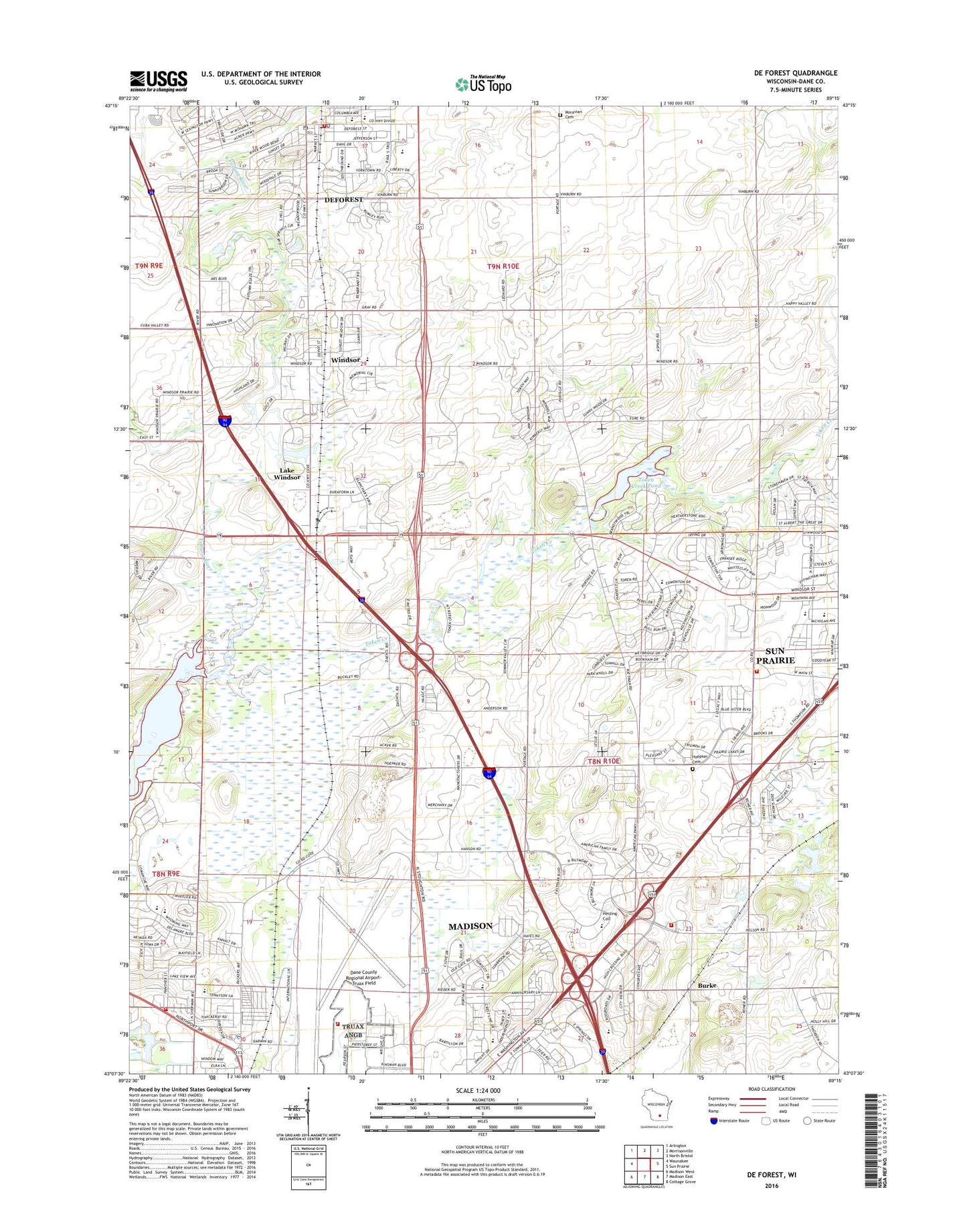
2022 topographic map quadrangle De Forest in the state of Wisconsin. Scale: 1:24000. Based on the newly updated USGS 7.5' US Topo map series, this map is in the following counties: Dane. The map contains contour data, water features, and other items you are used to seeing on USGS maps, but also has updated roads and other features. This is the next generation of topographic maps. Printed on high-quality waterproof paper with UV fade-resistant inks.
Quads adjacent to this one:
West: Waunakee
Northwest: Arlington
North: Morrisonville
Northeast: North Bristol
East: Sun Prairie
Southeast: Cottage Grove
South: Madison East
Southwest: Madison West
This map covers the same area as the classic USGS quad with code o43089b3.
Contains the following named places: Barman Farms, Berkley Park, Black Hawk Middle School, Burke, Burke Cemetery, Burke Lutheran Cemetery, Burke Lutheran Church, Burke Station Cemetery, Burke Station School, Cherokee Marsh State Fishery Area, Cherokee Marsh State Natural Area, Cherokee Park, Christ Lutheran Church, Creekside Elementary School, Dane County Regional Airport-Truax Field, Darwin, De Forest, De Forest Moravian Church, De Forest Museum, De Forest Public Library, De Forest Village Hall, DeForest Area Fire Department and Emergency Medical Services, DeForest Area High School, DeForest Area Middle School, DeForest Police Department, DeForest Post Office, Eagle Point Elementary School, Eastside Lutheran School, Essex Square Shopping Center, Firemens Park, Foxmoor Hills, Gompers Elementary School, Herzing University, Hoepkers Corners, Horizon Elementary School, Lake View Elementary School, Lake Windsor, Lake Windsor Country Club, Madison Fire Department Station 10, Madison Fire Department Station 11, Madison Police Department - North District, Madison Prairie Landfill, McCoy Farm, Moravian Cemetery, New Reflections School, Norway Grove Cemetery, Norway Grove Memorial Lutheran Church, Oak Park Terrace, Oakridge Park, Paulson Schwenn Quarry, Prairie View Middle School, Pumpkin Hollow Elementary School, Raintree, Regency Beauty Institute Madison, Reindahl Park, Royal Oaks Elementary School, Saint Albert the Great Church, Saint Olaf Catholic Cemetery, Saint Olafs Catholic Church, Sandburg Elementary School, Sanderson School, Sherman Park, Sherman Plaza Shopping Center, Sherwood Glen, Sun Prairie Emergency Medical Services Station 2, Sun Prairie Fire and Rescue Company Station 2, Sun Prairie Police Department - Westside, Sunburst, Token Creek, Token Creek Cemetery, Token Creek County Park, Token Creek Dam, Token Creek Pond, Token Creek School, Town of Burke, Town of Windsor, Truax Army Air Field, Truax Fire Department, University of Phoenix Madison Campus, Village of DeForest, Village of Windsor, Vincent School, Wangsness School, Warner Park, Western Green Area Park, Wheeler Wilcox Creek, Wilcox School, Windsor, Windsor Census Designated Place, Windsor Congregational Cemetery, Windsor Elementary School, Windsor Lake, Windsor Post Office, Windsor United Church of Christ, Wisconsin State Patrol - DeForest Post, WMAD-FM (Sun Prairie), Wynbrooke, Yahara Elementary School, ZIP Codes: 53598, 53704