MyTopo
Casper Wyoming US Topo Map
Couldn't load pickup availability
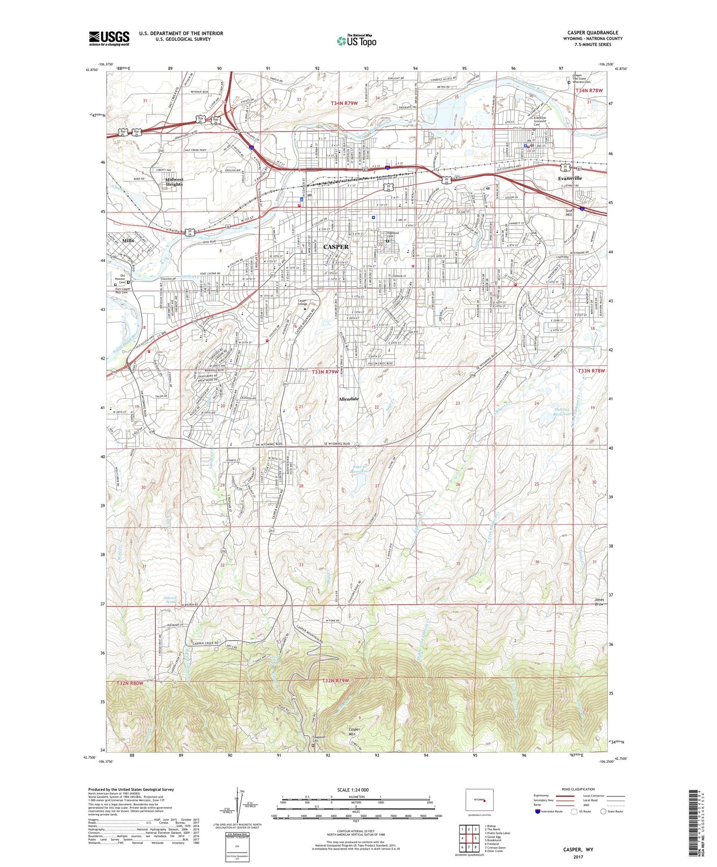
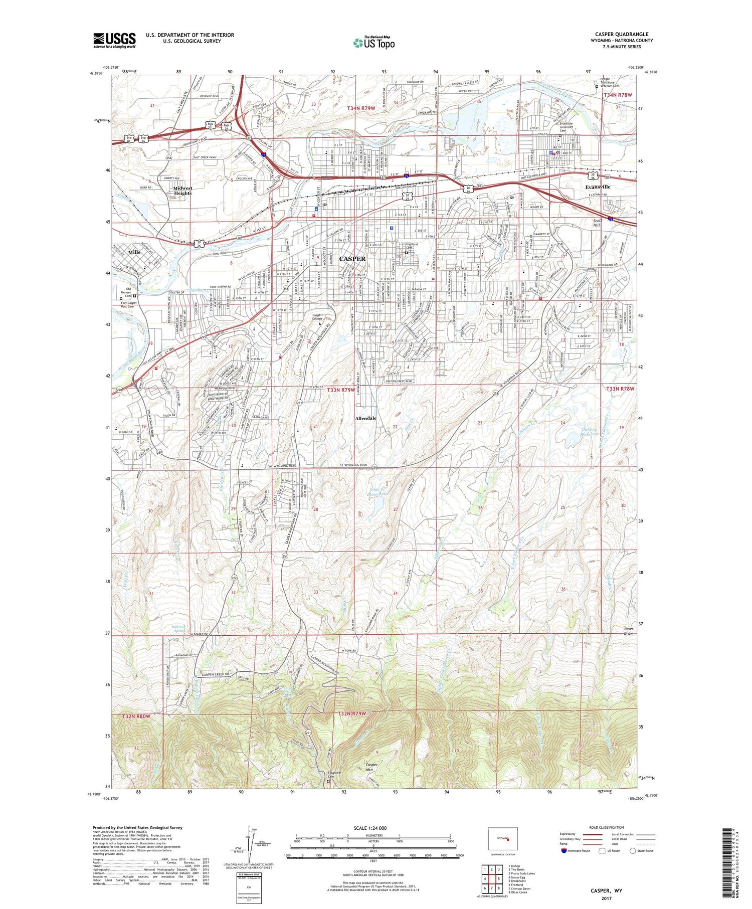
2021 topographic map quadrangle Casper in the state of Wyoming. Scale: 1:24000. Based on the newly updated USGS 7.5' US Topo map series, this map is in the following counties: Natrona. The map contains contour data, water features, and other items you are used to seeing on USGS maps, but also has updated roads and other features. This is the next generation of topographic maps. Printed on high-quality waterproof paper with UV fade-resistant inks.
Quads adjacent to this one:
West: Goose Egg
Northwest: Bishop
North: The Reefs
Northeast: Pratts Soda Lakes
East: Brookhurst
Southeast: Otter Creek
South: Crimson Dawn
Southwest: Freeland
Contains the following named places: Allendale, Beverly Plaza, Carroll Number 1 Dam, Carroll Number 1 Reservoir, Carroll Number 2 Dam, Carroll Number 2 Reservoir, Casper, Casper College, Casper Concrete Pit, Casper Country Club, Casper Creek, Casper Division, Casper Fire - Emergency Medical Services Station 1, Casper Fire - Emergency Medical Services Station 2, Casper Fire - Emergency Medical Services Station 3, Casper Fire - Emergency Medical Services Station 5, Casper Mountain, Casper Police Department, Casper Post Office, Casper Reservoir, City of Casper, Dean Morgan Middle School, Downtown Casper Post Office, Duhling Dam, Duhling Reservoir, East Fork Elkhorn Creek, East Fork Wolf Creek Dam, East Fork Wolf Creek Reservoir, East Junior High School, Eastdale Park, Eastridge Mall, Evansville, Evansville Elementary School, Evansville Fire Department and Emergency Medical Services, Evansville Police Department, Evansville Post Office, Evansville Storage Dam, Evansville Storage Reservoir, Evansvlle Gravesite, Fairdale School, Fort Caspar Academy, Fort Casper Historical Grounds, Fort Casper Post Cemetery, Fougstedt Cemetery, Garden Creek, Garden Creek Waterfall, Garfield School, Grant Elementary School, Hidebrand Pit, Highland Cemetery, Hillcrest Spring, Hilltop Shopping Center, Hospital Park, Huber Park, Jefferson School, KATI-AM (Casper), Katy Creek, Katy Dam, Katy Reservoir, Kaycee Clay Mine, Kaycee Mine, KCEB-FM (Casper), Koch Deposit Number Two, KVOC-AM (Casper), McKinley School, Middle Fork Elkhorn Creek, Midwest County Sheriff's Office, Midwest Heights, Midwest-Thoeming and Wakem Mine, Miller Dam, Miller Reservoir, Mills, Mills Elementary School, Mountain Plaza, Natrona County Sheriff's Office, North Casper Park, North Casper Shopping Center, Old Pioneer Cemetery, Oregon Trail State Veterans Cemetery, Park Elementary School, Pineview Elementary School, Rim Rock Ranch Pit, Riverside Shopping Center, Roosevelt School, Rotary Park, Sage Creek, Sage Creek Dam, Sage Creek Reservoir, Saint Anthony Tri - Parish Catholic School, Scott Hill, Southridge Elementary School, Spicer Upper Dam, Spicer Upper Reservoir, Summit Elementary School, Sunrise Shopping Center, Thorndale Acres, Town of Evansville, True Heliport, Washington Park, West Fork Garden Creek, Westridge Village Shopping Center, Westwood Park, Westwood School, Willard Elementary School, Wilson School, Wyoming Behavioral Institute, Wyoming Highway Patrol District 2 Division B, Wyoming Medical Center, Wyoming Medical Center Ambulance Service, Wyoming Medical Center Heliport, ZIP Code: 82644