MyTopo
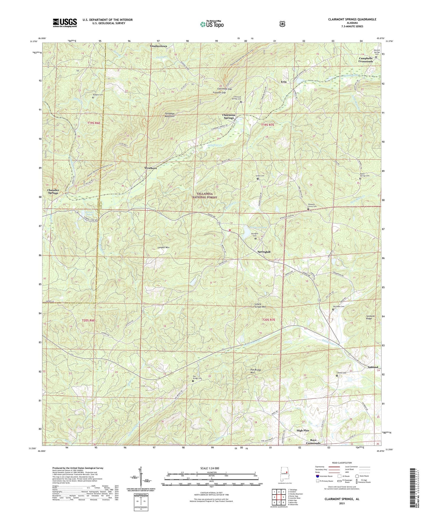
Clairmont Springs Alabama US Topo Map
Couldn't load pickup availability
Also explore the Clairmont Springs Forest Service Topo of this same quad for updated USFS data
2024 topographic map quadrangle Clairmont Springs in the state of Alabama. Scale: 1:24000. Based on the newly updated USGS 7.5' US Topo map series, this map is in the following counties: Clay, Talladega. The map contains contour data, water features, and other items you are used to seeing on USGS maps, but also has updated roads and other features. This is the next generation of topographic maps. Printed on high-quality waterproof paper with UV fade-resistant inks.
Quads adjacent to this one:
West: Porter Gap
Northwest: Talladega
North: Ironaton
Northeast: Cheaha Mountain
East: Lineville West
Southeast: Gibsonville
South: Millerville
Southwest: Bulls Gap
This map covers the same area as the classic USGS quad with code o33085c8.
Contains the following named places: Acme Mine, Alabama Graphic Mine, Alabama Number One Mine, Alabama Number Two Mine, Allen Mine, Antioch Church, Ashland Mine, Axton-Noe Mine, Blue Creek, Burgess Cemetery, Buzzard Creek, California Prospect, Campbells Crossroads, Caten Shoals Creek, Chandler Spring Station, Chandler Springs, Chickasaw Town, Clairmont Gap, Clairmont Springs, Clairmont Springs Cemetery, Clairmont Springs Church, Cole Bridge Church, Crucible Mine, Crucible Prospect, Eagle Mine, Eley Mine, Enitachopco, Enitachopco Mine, Enterprise Mine, Erin, Fairview Church, Fairview Church Cemetery, Friendship Church, Garing Creek, Gibson Mine, Gold Mines Creek, Graphite, Griessemer Mine, Gunthertown, Haraldson Mine, Heflin School, High Pine, High Pine Church, Hobbs Prospect, Horn Branch, Horne Dam, Hornes Lakes, Horns Peak Mine, Hudson Mine, Idaho, Idaho Mine, Idaho Volunteer Fire Department, Ironston Gap, Jackson Mine, Jefferson Mine, Kants Mill, Lee Number One Mine, Lee Number Two Mine, Liberty Cemetery, Liberty Church of Christ, Liberty School, Little Samson Prospect, Lizard Scrape Mountain, London Mountain, Markstein, May Brothers Mine, McLellan Mine, Mineral Springs Cemetery, Mineral Springs United Methodist Church, National Mine, Newbury Dam, Newburys Pond, Norway Mine, Old Noles Cemetery, Pitts Number One Mine, Pitts Number Two Mine, Pleasant Grove Cemetery, Pleasant Grove Church of Christ, Pocahontas Mine, Poe Bridge Cemetery, Poe Bridge Mountain, Quenelda, Quenelda Graphite Mines, Rays Crossroads, Sardis Cemetery, Sardis Church, Sewell-Caldwell Prospect, Southern Star Mine, Springhill, Springhill Baptist Church Cemetery, Springhill Church, Stevenson Mine, Stringfellow Prospect, Superior Mine, Wade Prospect, Weathers, Whatley Mine, Yamme