MyTopo
Columbus City Alabama US Topo Map
Couldn't load pickup availability
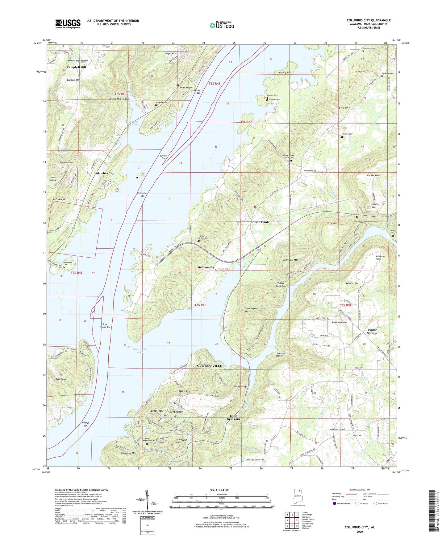
2024 topographic map quadrangle Columbus City in the state of Alabama. Scale: 1:24000. Based on the newly updated USGS 7.5' US Topo map series, this map is in the following counties: Marshall. The map contains contour data, water features, and other items you are used to seeing on USGS maps, but also has updated roads and other features. This is the next generation of topographic maps. Printed on high-quality waterproof paper with UV fade-resistant inks.
Quads adjacent to this one:
West: Mount Carmel
Northwest: Grant
North: Swearengin
Northeast: Langston
East: Grove Oak
Southeast: Painter
South: Albertville
Southwest: Guntersville
This map covers the same area as the classic USGS quad with code o34086d2.
Contains the following named places: Alabama Christian Youth Camp, Asbury, Asbury Methodist Church, Bailey Ridge, Bryant Mill Hollow, Buck Island, Buck Island Bar, Camp Ney A Ti, Camp Trico, Campbell Mill, Cedar Ridge, Center Point, Center Star Church, Chandler Branch, Chandler Cemetery, Columbus Bar, Columbus City, Columbus City Ferry, Columbus City Landing, Columbus City School, Cooper Cemetery, Duvall Branch, Ellenburg Mountain, Fairview Cemetery, Fairview Church, Five Points, Five Points School, Glen Haven, Graveyard Hill, Gunters Bar, Haney Chapel, Haney Chapel Cemetery, Haney Chapel School, Haney Chapel School Number 2, Harrison Reservation, Henrys Bar, High Point Church, Hurricane Branch, John Doss Mountain, Johnson Cemetery, Johnson Hollow, Johnsons Store, Kennamer Cemetery, King Chapel, King Chapel Cemetery, Kirby Cemetery, Lake Guntersville State Park, Law Landing, Little Mountain, Little Mountain Marina, Little New York, Lovelace Landing, Lower Bar, McCorkle Mountain, McDonald Spring, Meltonsville, Mid, Mill Creek, Minky Creek, Mount High Primitive Baptist Church, Mount Moriah Church Cemetery, Mount Moriah Methodist Church, Mount Moriah School, Murphy Hill, Negro Mountain, Old Union Branch, Pine Island, Pine Island Church, Pine Island Landing, Poplar Springs, Poplar Springs Church, Poplar Springs School, Prospect Cemetery, Prospect Church, Rainey Cemetery, Rooks Cemetery, Sandridge Church, Smith Cemetery, Smith Gap, Stubblefield Mountain, Sycamore Landing, Tanglewood, Taylor Mountain, The Narrows, Thomason Cemetery, Town Creek, Town Creek Division, Town Creek Ferry, Turner Marina, Village Ford Gap, Wakefield Community Center, Wakefield Volunteer Fire Department, Waterfront Fire Department, Williams Point, Winston Gap, Woosley Cemetery, ZIP Code: 35755