MyTopo
Langston Alabama US Topo Map
Couldn't load pickup availability
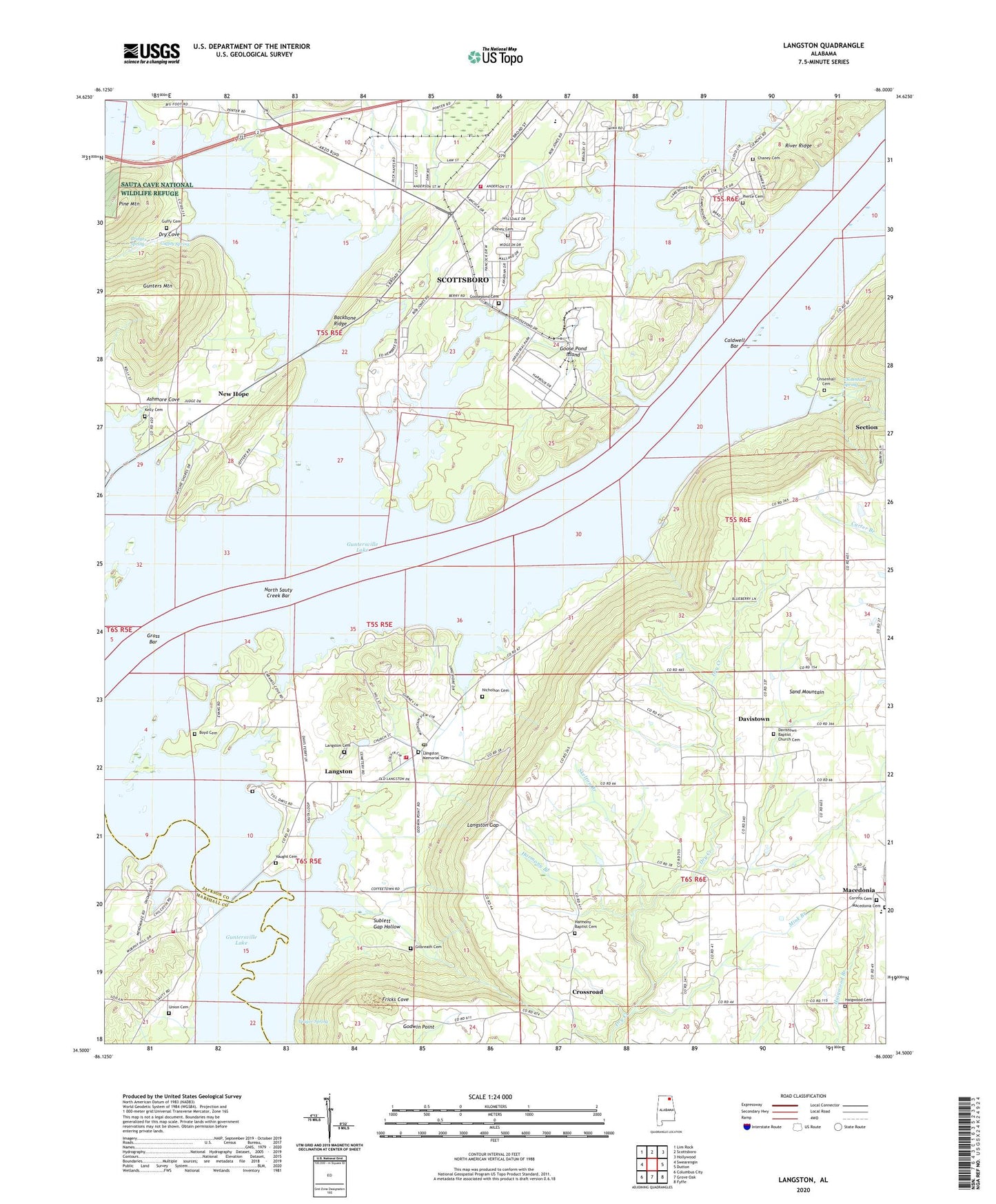
2024 topographic map quadrangle Langston in the state of Alabama. Scale: 1:24000. Based on the newly updated USGS 7.5' US Topo map series, this map is in the following counties: Jackson, Marshall. The map contains contour data, water features, and other items you are used to seeing on USGS maps, but also has updated roads and other features. This is the next generation of topographic maps. Printed on high-quality waterproof paper with UV fade-resistant inks.
Quads adjacent to this one:
West: Swearengin
Northwest: Lim Rock
North: Scottsboro
Northeast: Hollywood
East: Dutton
Southeast: Fyffe
South: Grove Oak
Southwest: Columbus City
This map covers the same area as the classic USGS quad with code o34086e1.
Contains the following named places: Ashmore Cove, Backbone Ridge, Boyd Cemetery, Bridges Spring, Caldwell Bar, Caldwell Ferry, Chaney Cemetery, Chisenhall Cemetery, Chisenhall Spring, Corinth Church, Crossroad, Crossroads School, Davistown, Davistown School, Dodsonville, Dry Cove, Finney Cemetery, Fort Payne Boating Club, Fricks Cove, Goose Pond Colony Park, Goose Pond Crossroads, Goose Pond Island, Goosepond Cumberland Presbyterian Church, Gross Bar, Gross Landing, Guffey Spring, Guffy Cemetery, Guntersville Lake, Haigwood Church, Hale School, Harmony Branch, Harmony Church, Hollis Memorial Church, Kelly Cemetery, Lake Shore Drive Cabin Site Area, Lakeview Shores, Langston, Langston Cemetery, Langston City Park, Langston Gap, Langston Post Office, Langston School, Langston Volunteer Fire Department, Larkin Ferry, Larkin Landing, Larkins Towhead, Macedonia, Macedonia School, Mink Branch, Mink Creek, Mink Creek Bar, Mink Creek Cabin Site Area, New Hope, New Hope School, Nicholson Cemetery, North Alabama Presbyterian Camp, North Sauty Creek, North Sauty Creek Bar, North Sauty Wildlife Refuge, Oak Grove Church, Pierce Cemetery, Pine Mountain, Pleasant Grove Church, Riley Reservation, Roman Cemetery, Roseberry Creek, Saint Joseph School, Sauta, Sauta Post Office, Scottsboro Fire Department Station 2, Scottsboro Municipal Park, Section Ferry, Skelton Branch, Skyline Shores, South Sauty Church, South Sauty Creek, South Sauty Point Cabin Site Area, South Sauty Volunteer Fire Department, Staples Landing, Sublett Gap Hollow, Temperance Hill School, Town of Langston, Tupelo Swamp, Union Cemetery, Vaught Cemetery, Welcome Hill Church, Wiley Lake, Yeager Spring, ZIP Codes: 35769, 35771