MyTopo
Guntersville Alabama US Topo Map
Couldn't load pickup availability
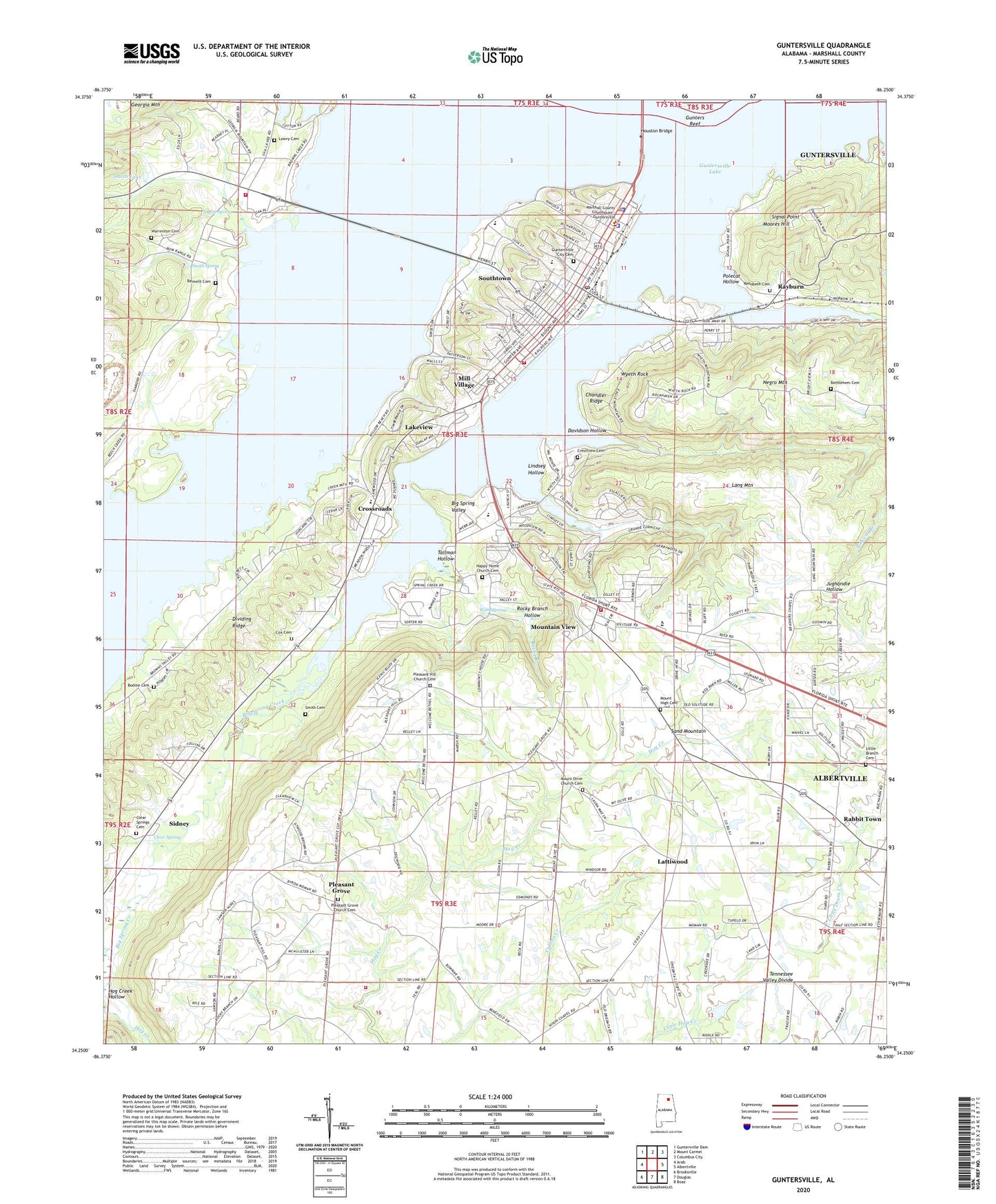
2024 topographic map quadrangle Guntersville in the state of Alabama. Scale: 1:24000. Based on the newly updated USGS 7.5' US Topo map series, this map is in the following counties: Marshall. The map contains contour data, water features, and other items you are used to seeing on USGS maps, but also has updated roads and other features. This is the next generation of topographic maps. Printed on high-quality waterproof paper with UV fade-resistant inks.
Quads adjacent to this one:
West: Arab
Northwest: Guntersville Dam
North: Mount Carmel
Northeast: Columbus City
East: Albertville
Southeast: Boaz
South: Douglas
Southwest: Brooksville
This map covers the same area as the classic USGS quad with code o34086c3.
Contains the following named places: Bennett Cemetery, Bethlehem Cemetery, Big Spring Creek, Big Spring Creek Small Wild Area, Big Spring Valley, Bodine Cemetery, Bond Chapel, Carlisle Junior High School, Chandler Ridge, Cherokee School, City of Guntersville, Clear Spring, Clear Springs Cemetery, Clear Springs Church, Country Club Estates, Cox Cemetery, Crestview Cemetery, Crossroads, Crossroads School, David Crockett Visit Lions Club Park, Davidson Hollow, Finlay Plaza Shopping Center, First Baptist Church, First Presbyterian Church, Georgia Mountain Volunteer Fire Department Station 2, Gethsemane Church, Gregory, Gunter Landing, Gunters Reef, Guntersville, Guntersville City Cemetery, Guntersville Division, Guntersville Ferry, Guntersville Fire and Rescue Station 1, Guntersville Fire and Rescue Station 2, Guntersville High School, Guntersville Hospital, Guntersville Marina, Guntersville Municipal Park, Guntersville Police Department, Guntersville Post Office, Guntersville Recreation Center, Guntersville Shores, Happy Home Church, Happy Home Church Cemetery, Hide Away Acres, Hog Creek, Hog Creek Hollow, Houston Bridge, Lake Shopping Center, Lakeview, Lakeview Heights School, Lang Mountain, Lattiswood School, Lattiwood, Lindsay Lane, Lindsey Hollow, Little Branch Cemetery, Little Branch Church, Lowry Cemetery, Mahans Store, Marshall County, Marshall County Courthouse, Marshall County Farm, Marshall County High School, Marshall County Nursing Home, Marshall County Sheriff's Office, Marshall County Technical School, Marshall Medical Professional Center, Meadow Wood, Mill Village, Moore Pond, Moores Hill, Morrow Acres, Mount High Cemetery, Mount High Church, Mount Olive Baptist Church, Mount Olive Church Cemetery, Mountain View, Negro Mountain, Ogletree Park, Pine Grove Church, Piney Grove Church, Pleasant Grove, Pleasant Grove Church Cemetery, Pleasant Grove Missionary Baptist Church, Pleasant Grove School, Pleasant Grove Volunteer Fire Department, Pleasant Hill Church, Polecat Branch, Polecat Hollow, Rabbit Town, Rayburn, Rehobeth Cemetery, Rehobeth Missionary Baptist Church, Rocky Branch, Rocky Branch Hollow, Sidney, Signal Point, Sims School, Smith Cemetery, Smith Lake, Smith Landing Field, Smith Shores, Smith Spring, Solid Rock Church, Solitude Church, Solitude School, South Gate Shopping Center, Southtown, Spring Creek Marina, Street, Sunrise Shores, Tallman Hollow, Taylor Spring, Tom Jackson Park, Union Church, United Cherokee Ani-Yun-Wiya Nation State Designated Tribal Statistical Area, Val Monte Country Club, Val Monte Marina, Valley View Church, Ward Spring, Warrenton, Warrenton Cemetery, Warrenton Church, Warrenton School, Welcome Bethel Church, WGSV-AM (Guntersville), WTWX-FM (Gunthersville), Wyeth City, Wyeth Rock, ZIP Code: 35976