MyTopo
Dora Alabama US Topo Map
Couldn't load pickup availability
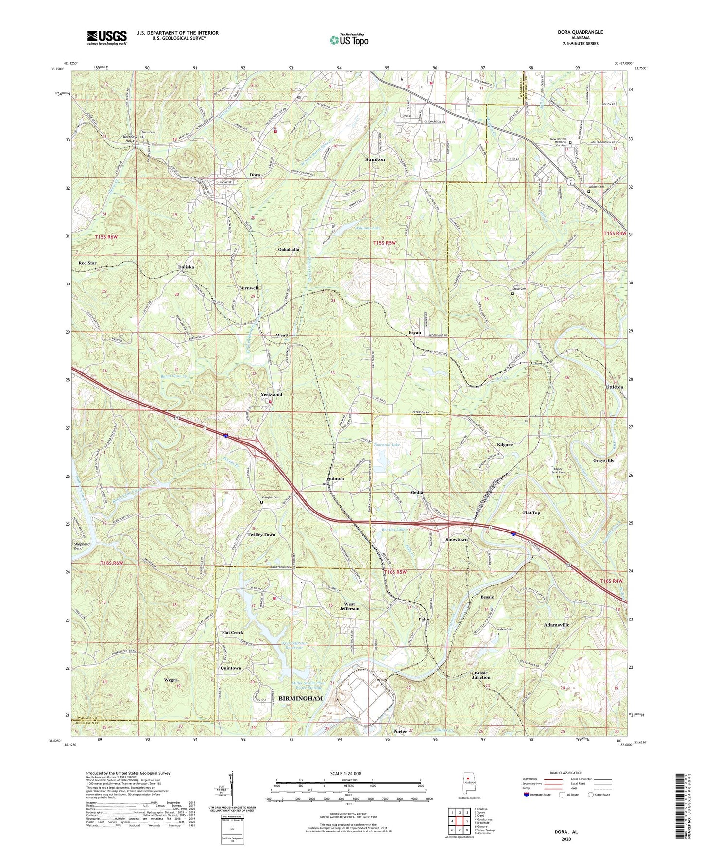
2024 topographic map quadrangle Dora in the state of Alabama. Scale: 1:24000. Based on the newly updated USGS 7.5' US Topo map series, this map is in the following counties: Walker, Jefferson. The map contains contour data, water features, and other items you are used to seeing on USGS maps, but also has updated roads and other features. This is the next generation of topographic maps. Printed on high-quality waterproof paper with UV fade-resistant inks.
Quads adjacent to this one:
West: Goodsprings
Northwest: Cordova
North: Sipsey
Northeast: Creel
East: Brookside
Southeast: Adamsville
South: Sylvan Springs
Southwest: Gilmore
This map covers the same area as the classic USGS quad with code o33087f1.
Contains the following named places: Adams Cemetery, Ambeto, Bagley Bend Cemetery, Bagley Bend North Mine, Banner, Barnes Branch, Bentley Lake, Bergens, Bessie, Bessie Elementary School, Bessie Junction, Bessie Mine, Bessie Mines - Number 3 Impoundment Dam, Bessie Mines Number 3 Impoundment, Bethel Church, Bibby, Bible Church of God, Black Creek Number 4 Mine, Black Creek School, Briarcliff Estates, Bryan, Bryan Church, Burnt Cane Creek, Burnwell, Burnwell Mines, Burnwell Station, Butlers Ferry, Calvary Church, Canaan Church, Cane Creek, City of Adamsville, City of Dora, Colley Elementary School, Crestview Estates, Crews Mobile Home Park, Davis Cemetery, Davis Mines, Dawson School, Doliska, Dora, Dora High School, Dora Mine, Dora Pit Mine, Dora Police Department, Dora Post Office, Dora Volunteer Fire Department, Faith Church, Falls Creek, Fivemile Creek, Flat Bank Ford, Flat Creek, Flat Top, Flat Top Mine, Flat Top Mine - Number 1 Impoundment Dam, Flat Top Mine Number 1 Impoundment, Freewill Church, Gamma Slope Mine, Glover Ferry, Goodwin Mine, Jarmons Mine, Kershaw Hollow, Kilgore, Kilgore Church, Lawler Baptist Church, Lawler Cemetery, Liberty Church, Lindbergh Mine, Littleton Ferry, Long Shoal Ford, Maben Cemetery, Maben Elementary School, McDonalds Mill, McLean Mine, Media, Mill Creek, Mill Creek Estates, Miller Steam Plant, Miller Steam Plant Water Storage, Morgan Chapel, Morgan Creek, Morgan Mine, Mount Arat Church, Mount Hope Church, Musgrove Pratt Mine, New Horizon Memorial Gardens, Oakahalla, Obes Creek, Palos, Palos Number 3 Mine, Parkville, Piedmont Mine, Pratt Consolidated Mines, Quinton, Quinton Post Office, Quintown, Red Star, Reeds Ferry, Reeds Ferry Camp, Riverside Estates, Royal Drift Mine, Shanghai Cemetery, Shanghi Baptist Church, Shepards Landing, Snowtown, Snowtown Church, Sumiton Church of God, Sumiton Fire and Rescue Service, Thornton Lake, Thornton Lake Dam, Town of West Jefferson, Tuggles Landing, Twilley Town, Twilly Town Church, Union Grove Cemetery, Victor Mine, W H Williams Junior Dam, Walker State Technical College, Wegra, Wegra Church, West Fork Burnt Cane Creek, West Jefferson, West Jefferson Baptist Church, West Jefferson High School, West Jefferson Reservoir, West Jefferson Town Hall, West Jefferson Volunteer Fire Department, Wileys Mill, Williams Lake, Wolf Branch, Wyatt, Wyatt Station Baptist Church, Yearkwood Mine, Yerkwood, Yerkwood Volunteer Fire Department, ZIP Code: 35062