MyTopo
Brookside Alabama US Topo Map
Couldn't load pickup availability
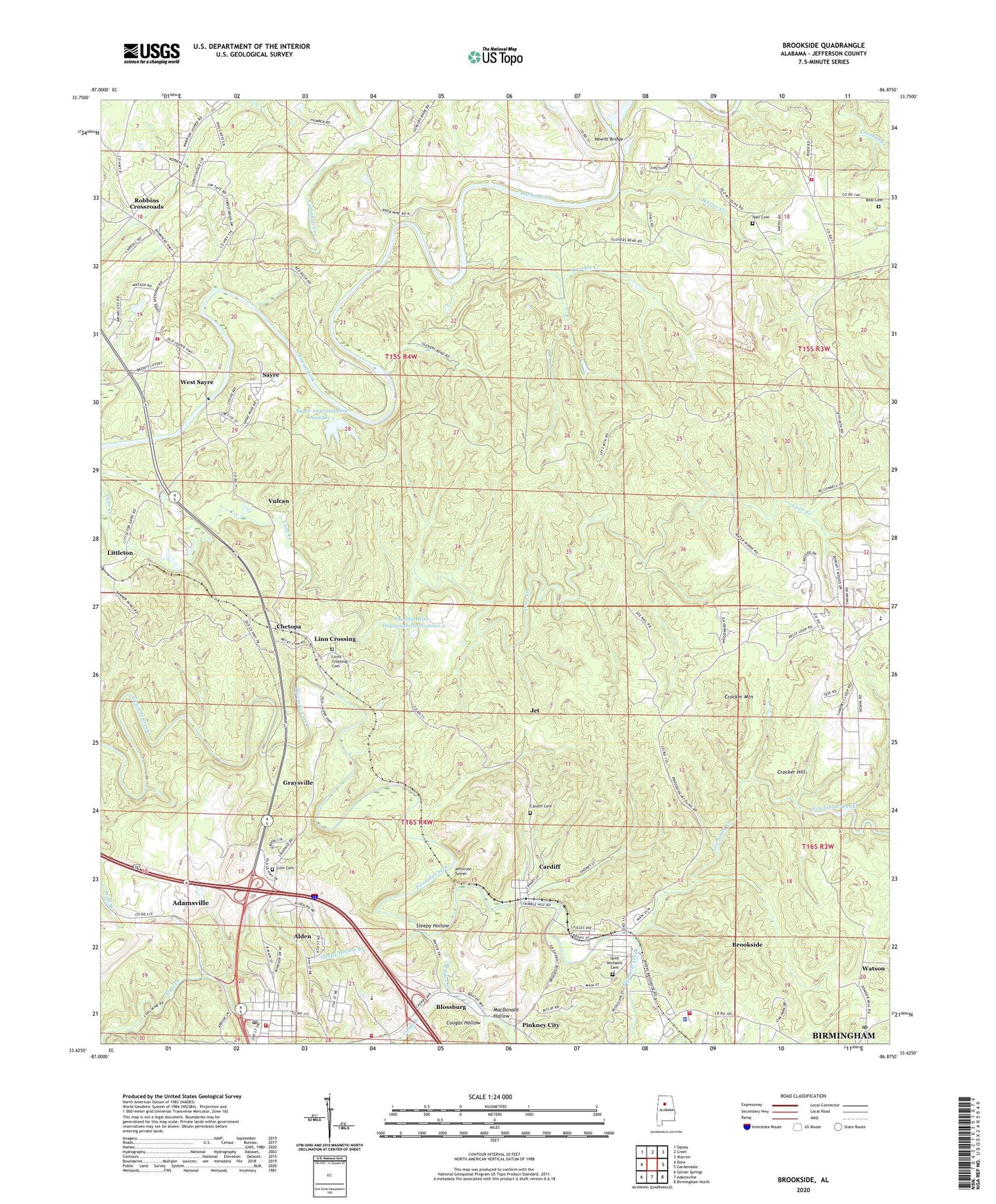
2024 topographic map quadrangle Brookside in the state of Alabama. Scale: 1:24000. Based on the newly updated USGS 7.5' US Topo map series, this map is in the following counties: Jefferson. The map contains contour data, water features, and other items you are used to seeing on USGS maps, but also has updated roads and other features. This is the next generation of topographic maps. Printed on high-quality waterproof paper with UV fade-resistant inks.
Quads adjacent to this one:
West: Dora
Northwest: Sipsey
North: Creel
Northeast: Warrior
East: Gardendale
Southeast: Birmingham North
South: Adamsville
Southwest: Sylvan Springs
This map covers the same area as the classic USGS quad with code o33086f8.
Contains the following named places: Alden, Alden Elementary School, Antioch Baptist Church, Bagley Volunteer Fire and Rescue, Baileys Quarters, Banner Mines, Banner New Mine, Banner Shaft Mine, Bibb Cemetery, Blossburg, Blossburg Mine, Brazil Mine, Brents Cross Roads, Brookside, Brookside Division, Brookside Elementary School, Brookside Fire Rescue Department, Brookside High School, Brookside Mine, Brookside Police Department, Brookville School, Calcedonia Baptist Church, Campbell Creek, Cardiff, Cardiff Cemetery, Cardiff Drift Mine, Chetopa, Chetopa Mine, Chetopa Mine - Impoundment Number 2, City of Graysville, Coal Creek Mine, Cougar Hollow, Cow Branch, Crocker Church, Crocker Drift Mine, Crocker Hill, Crocker Junction, Crocker Mountain, Divide Station, Durant Mines, Erskine Mine, Flat Top Mine, Good Hope Church, Goode Mines, Graysville Fire Department Station 1, Graysville Fire Department Station 2, Graysville First United Methodist Church, Graysville Junior High School, Graysville Police Department, Graysville Post Office, Hewitt Bridge, Island Ford, Jefferson Tunnel, Jet, John Bensko Park, Knob Mine, Kosmo Mines, Lees Chapel, Linn Cemetery, Linn Crossing, Linns Crossing Cemetery, Littleton, Littleton Mine, Loller Ferry, MacDonald Hollow, Meadows Chapel Church, Mineral Springs, Mount Olive Elementary School, Mount Olive Fire and Rescue District Station 2, Mount Pisgah Church, Narl Cemetery, Nebo, New Found Creek Lake Dam, New Found Mines, Newfound Creek, Newfound Creek Lake, Old Calcedonia Church, Orono, Orono Mine, Pinkney City, Pinkney City Elementary School, Pinkney Number 3 Mine, Prudes Creek, Rilma, Robbins Crossroads, Robbins Crossroads Division, Saint Michaels Cemetery, Saint Nicholas Russian Orthodox Church, Saint Pauls Church, Sardis Church, Sayre, Sayre Church, Sayre Impoundment Number 1, Sayre Impoundment Number 1 Dam, Sayre Junior High School, Sayre Mine, Sayre United Methodist Church, Sharon Church, Short Ferry, Sleepy Hollow, Sleepy Hollow Branch, Stumptown, Town of Brookside, Town of Cardiff, Trouble Creek, United States Reservation - Flat Top Experimental Forest, Victor School, Vulcan, Watson, Watson Post Office, West Blossburg, West Sayre, Whites Creek, ZIP Codes: 35036, 35073, 35117, 35139