MyTopo
Sipsey Alabama US Topo Map
Couldn't load pickup availability
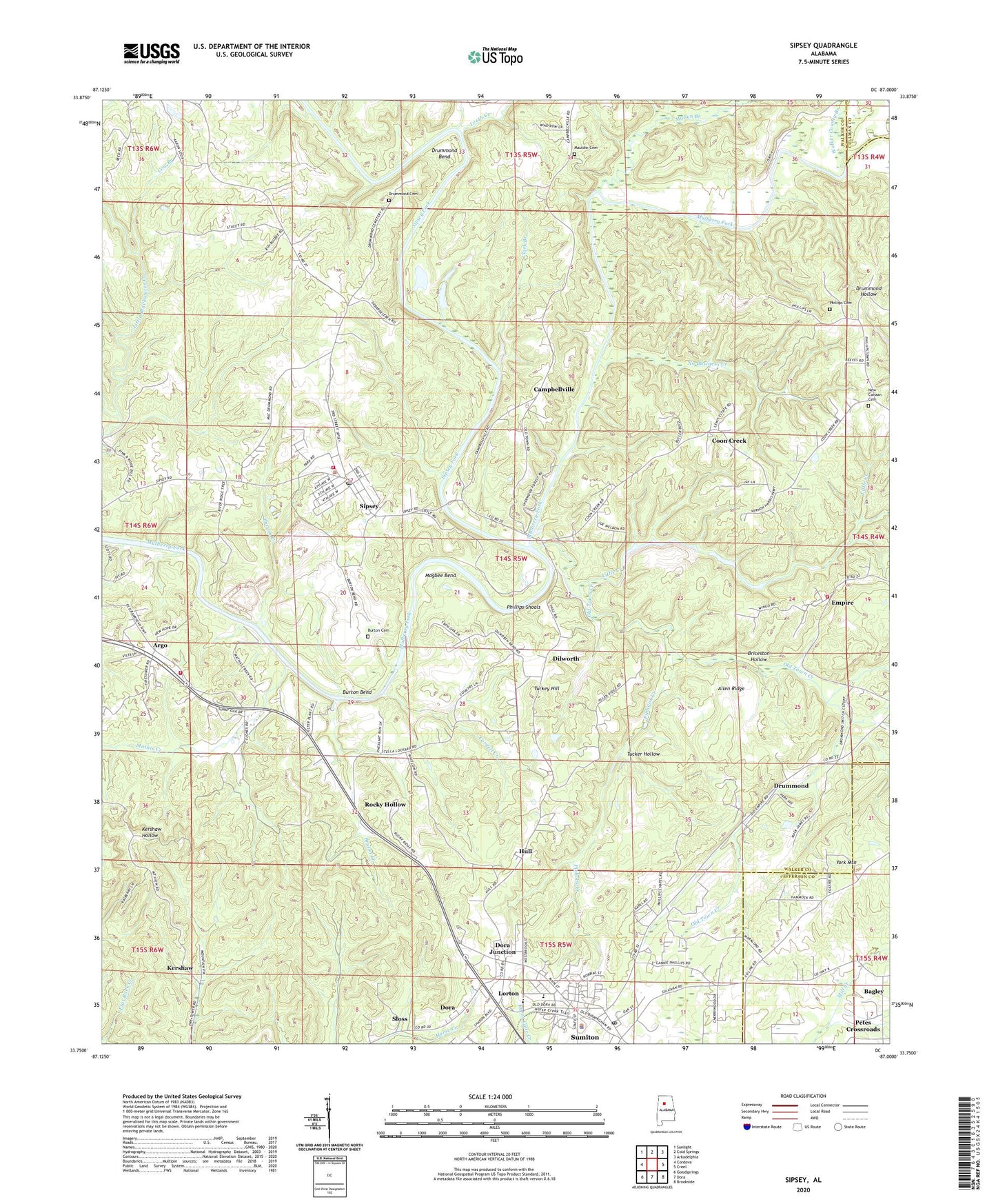
2024 topographic map quadrangle Sipsey in the state of Alabama. Scale: 1:24000. Based on the newly updated USGS 7.5' US Topo map series, this map is in the following counties: Walker, Jefferson, Cullman. The map contains contour data, water features, and other items you are used to seeing on USGS maps, but also has updated roads and other features. This is the next generation of topographic maps. Printed on high-quality waterproof paper with UV fade-resistant inks.
Quads adjacent to this one:
West: Cordova
Northwest: Sunlight
North: Cold Springs
Northeast: Arkadelphia
East: Creel
Southeast: Brookside
South: Dora
Southwest: Goodsprings
This map covers the same area as the classic USGS quad with code o33087g1.
Contains the following named places: Akins Grove Church, Allen Ridge, Argo, Argo Area Volunteer Fire Department, Argo Church, Argo School, Arthur Owens Mine, Aycock Mine, Bagley, Baltimore Ford, Ben Gilbert Mine, Bill Grey Dam, Black Warrior Town, Bowden Mine, Briceston Hollow, Bruton Creek, Burton Bend, Burton Cemetery, Burton Creek, Burtons Ferry, Bush Tower, Byrd-Cole Number 6 Mine, Camp Sumiton, Campbellville, City of Sumiton, Clark Branch, Clark Hollow Mine, Commercial, Coon Creek, Cordal Creek Mine, Cordell Creek, Country Village Shopping Center, Cow Branch, Debardeleben, Dickson Ford, Dilworth, Dilworth Church, Dilworth Drift Mine, Dilworth Memorial Church, Dodd Spring School, Dora Division, Dora Junction, Drummond, Drummond Bend, Drummond Cemetery, Drummond Ferry, Eastside Mine, Empire, Empire Division, Empire Drift Mine, Empire Junior High School, Empire Mine, Empire Town Creek Mine, Empire Volunteer Fire Department, Freewill Church, Gravleeton, Headrick Mine, Henson Mine, Hull, Hull Mine, Ivy Mine, Jim Light Branch, Kerny Mine, Kershaw, Kingdom Hall of Jehovahs Witnesses, Kirkwood Mine, Lake Grey, Layton Mine, Ledbetter Mine, Leeth Creek, Levan Number 2 Mine, Little Creek, Little Creek Impoundment Dams, Little Creek Mine Lake, Lloyd-Watson Mine, Lorton, Magbee Bend, Mathis Creek, Mauldin Cemetery, Mount Pilgrim Church, Mullen Branch, New Canaan Baptist Church Cemetery, New Canaan Church, New Hope Church, No Business Creek, Oak Grove Church, Old Sipsey Mine, Old Town Creek, Owens Chapel Church, Petes Crossroads, Phillips Cemetery, Phillips Chapel, Phillips Church, Phillips Ferry, Phillips Landing, Phillips School, Phillips Shoals, Pinhook Creek, Pisgah Church, Pledger Mine, Pugh Mine, Rices Chapel, Rocky Hollow, Rollo Mine, Rowe Mine, Sipsey, Sipsey Church, Sipsey Fork, Sipsey Junior High School, Sipsey Mine, Sipsey Police Department, Sipsey Post Office, Sipsey Volunteer Fire Department, Sloss, Stith Mine, Sumiton, Sumiton City Hall, Sumiton Elementary School, Sumiton Police Department, Sumiton Post Office, Sumiton Trailer Park, Town of Sipsey, Tremble Mine, Tucker Hollow, Turkey Hill, Walker County Branch, Wheeler School, Winfred Owens Mine, WPYK-AM (Dora), WRSM-AM (Sumiton), York Mine, ZIP Codes: 35063, 35148, 35584