MyTopo
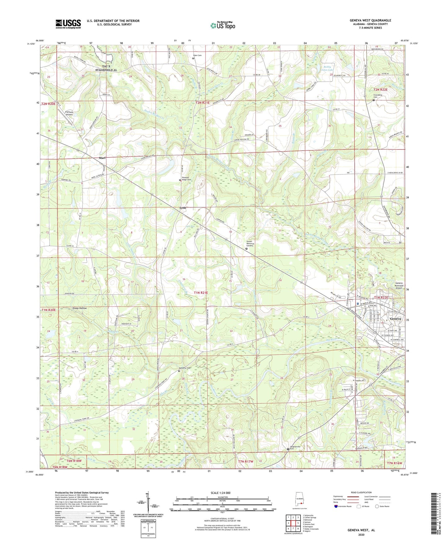
Geneva West Alabama US Topo Map
Couldn't load pickup availability
2024 topographic map quadrangle Geneva West in the state of Alabama. Scale: 1:24000. Based on the newly updated USGS 7.5' US Topo map series, this map is in the following counties: Geneva. The map contains contour data, water features, and other items you are used to seeing on USGS maps, but also has updated roads and other features. This is the next generation of topographic maps. Printed on high-quality waterproof paper with UV fade-resistant inks.
Quads adjacent to this one:
West: Samson
Northwest: Sellersville
North: Coffee Springs
Northeast: Bellwood
East: Geneva East
Southeast: Izagora
South: Hobbs Crossroads
Southwest: Darlington
This map covers the same area as the classic USGS quad with code o31085a8.
Contains the following named places: Beaverdam Creek, Bobby Jones Lake, Bobby Jones Lake Dam, Boggy Branch, Bushy Branch, Center Ridge School, Christian Science Church, Church of God, Church of Peace, City of Geneva, Costilla, Devco Baptist Church, Eden Cemetery, Eden Missionary Baptist Church, Emmanuel Assembly of God, Fairlane Airport, First United Pentecostal Church, Flat Branch, Friendship Baptist Church, Friendship Cemetery, Geneva Division, Geneva First Assembly of God, Geneva High School, Geneva Wastewater Treatment Plant, Hugh Owen Memorial Stadium, Jack Ausley Dam, Jack Ausley Lake, Joe Roeny Number 1 Dam, Joe Roeny Number 2 Dam, Keith Mill Branch, Laddon Church, Laddon Creek, Lakeside Estates Dam, Lime Branch, Limestone Branch, Little Sandy Creek, Long Branch, Long Branch Church, Long Branch School, Lytle, Lytle Bay, Maple Avenue Baptist Church, Marl, McDuffie Cemetery, Midway School, Mims Hill Assembly of God, Morris Mill, Morrisville, New Bethel African Methodist Episcopal Church, New Prospect Church, Pleasant Ridge Cemetery, Pleasant Ridge United Methodist Church, Riverside Heights High School, Sandy Creek, Sellers Branch, Somerset, Southside Church, SpectraCare Health Systems Geneva County Clinic, Steep Hollow, Sunset Memorial Gardens, The Church of Jesus Christ of Latter Day Saints, Threemile Branch, Vaughanville, Vaughanville Cemetery, Vaughanville Church, Vaughn School, Westside United Methodist Church, Windham School, Wiregrass Hospital Airport, Wiregrass Medical Center, Wiregrass Nursing Home, ZIP Code: 36340