MyTopo
Oakman Alabama US Topo Map
Couldn't load pickup availability
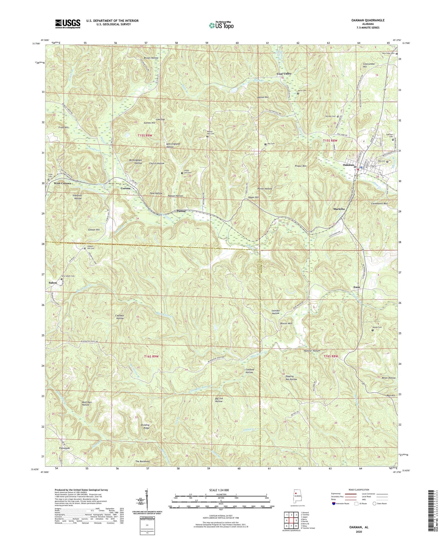
2024 topographic map quadrangle Oakman in the state of Alabama. Scale: 1:24000. Based on the newly updated USGS 7.5' US Topo map series, this map is in the following counties: Walker, Fayette. The map contains contour data, water features, and other items you are used to seeing on USGS maps, but also has updated roads and other features. This is the next generation of topographic maps. Printed on high-quality waterproof paper with UV fade-resistant inks.
Quads adjacent to this one:
West: Berry
Northwest: Howard
North: Townley
Northeast: Jasper
East: Parrish
Southeast: Tutwiler School
South: Wiley
Southwest: Berry SE
This map covers the same area as the classic USGS quad with code o33087f4.
Contains the following named places: Bee Spring Branch, Bethel, Bethel Church, Big Jim Hollow, Birmingham Hollow, Biscuit Mountain, Black Branch, Blue Water Creek, Brown Hollow, Cave Number 7 Drift Mine, Central Baptist Church, Church Hollow, Church of God of Prophecy, Clayton Church, Clemments Mountain, Coal Valley, Coal Valley Drift Mine, Coal Valley Number 1 Mine, Coal Valley Number 10 Mine, Coal Valley Number 11 Mine, Coalbed Hollow, Corona, Corona Church, Corona Mine, Corona Number 12 Mine, Corona Number 13 Mine, Corona Number 15 Mine, County Line Branch, Cowcumber Hill, Davis Cemetery, Day Cemetery, Days Gap Drift Mine, Deer Creek Mine, Dickey Branch, Dipping Vat Hollow, Dividing Ridge, Enoe, Enon Church, Enslen Drift Mine, Frost Cemetery, Frost Creek, Frost Drift Mine, Gaines Hill, Gaslight Mine, Gibson Hill, Gibson Hill Cemetery, Gibson Hill Church, Gibson Hill Mine, H D Collins Field, Hamner Hollow, Hayes Crossing, Hayes Hill, Infant Hill Cemetery, Jenkins Branch, Key Cemetery, Key Hill, Key Hill Church, Lick Branch, Little Blue Water Creek, Lockhart, Low Gap, Marietta, Marietta Mine, Mary Emma Mine, Mount Olive Church, Mountain Valley, Mountain Valley Mine, New England Hollow, New Hope Cemetery, New Hope Church of Christ, New Salem Cemetery, Oakman, Oakman Cemetery, Oakman Church of Christ, Oakman Church of God, Oakman Elementary School, Oakman First Baptist Church, Oakman High School, Oakman Methodist Church, Oakman Mine, Oakman Number 2 Mine, Oakman Police Department, Oakman Post Office, Oakman Volunteer Fire Department, Old Lebanon Church, Patton, Patton Baptist Church, Patton Hill, Patton Hill Cemetery, Patton Hill Fire Tower, Patton Hollow, Patton Number 3 Slope Mine, Pendley Creek, Porter Hollow, Propst Mountain, Propst Mountain Mine, Red Hill, Rocky Branch, Salem, Salem Church, Shelton Branch, Stanford Hollow, Stephenson Crossing, Swindle Cemetery, Swindle Hollow, Tank Hollow, The Backbone, Theron Wood Mine, Town of Oakman, West Corona, West Corona Mine, Willie Mae Mine, Wolf Den Hollow, Woods Cemetery