MyTopo
Orange Beach Alabama US Topo Map
Couldn't load pickup availability
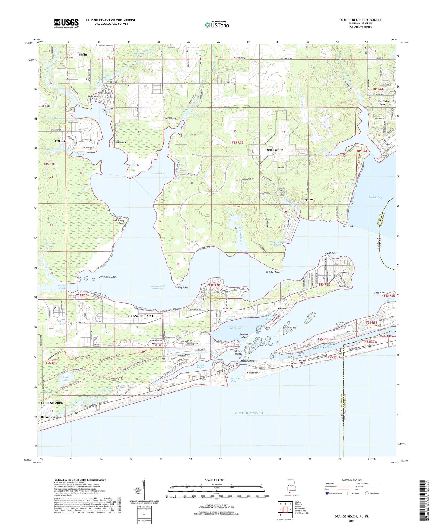
2025 topographic map quadrangle Orange Beach in the states of Alabama, Florida. Scale: 1:24000. Based on the newly updated USGS 7.5' US Topo map series, this map is in the following counties: Baldwin, Escambia. The map contains contour data, water features, and other items you are used to seeing on USGS maps, but also has updated roads and other features. This is the next generation of topographic maps. Printed on high-quality waterproof paper with UV fade-resistant inks.
Quads adjacent to this one:
West: Gulf Shores
Northwest: Foley
North: Elberta
Northeast: Lillian
East: Perdido Bay
Southwest: Gulf Shores OE S
Contains the following named places: Adventure Island Amusement Park, Alabama Marine Police Department, Alabama Point, Arnica Bay, Baldwin Baptist Camp, Bayou La Launch, Bayou Saint John, Bear Point, Bear Point Marina, Bobby Walker Marina, Callaways Landing, Caswell, Christian Life Church, City of Orange Beach, Cotton Bayou, Cotton Bayou Marina, Elberta Volunteer Fire Department Station 2, Florida Point, Gilchrist Island, Goat Bayou, Goat Point, Graham Bayou, Griffith's Marina, Gulf Bays, Gum Branch, Hammock Bay, Hammock Creek, Hatcher Point, Ingram Bayou, Johnson Cove, Josephine, Josephine Baptist Church, Josephine Volunteer Fire Department, Little Lake, Middle River, Miflin, Miflin Creek, Mill Point, Moccasin Bayou, Mulberry Point, Oleander Court Mobile Home Park, Orange Beach, Orange Beach Fire and Rescue Station 1, Orange Beach Fire and Rescue Station 2, Orange Beach Fire Department Station 3, Orange Beach Golf Center, Orange Beach Highway 180 Wastewater Treatment Plant, Orange Beach Indian and Sea Museum, Orange Beach Marina, Orange Beach Police Department, Orange Beach Post Office, Orange Beach Presbyterian Church, Orange Beach Public Library, Owens Bayou, Palmetto Creek, Perdido Beach, Perdido Beach Volunteer Fire Department, Perdido Church, Perdido Key, Perdido Pass, Perdido Pass Marina, Peterson Point, Pirates Cove Marina and Boat Yard, Portage Creek, Randolph, Roberts Bayou, Robinson Island, Romar Beach, Romar Harbor Marina, Ross Point, Safe Harbor Marina, Sandy Creek, Sapling Point, Sportsman Marina, Spring Branch, Stone Quarry Bayou, Terry Cove, Town of Elberta, Town of Perdido Beach, Trents Marina, Walker Island, Whispering Pines Mobile Home Park, Wolf Bay, Wolf Bay Park Mobile Home Park, Wolf Creek, Zeke's Landing Marina, ZIP Code: 36561