
MyTopo
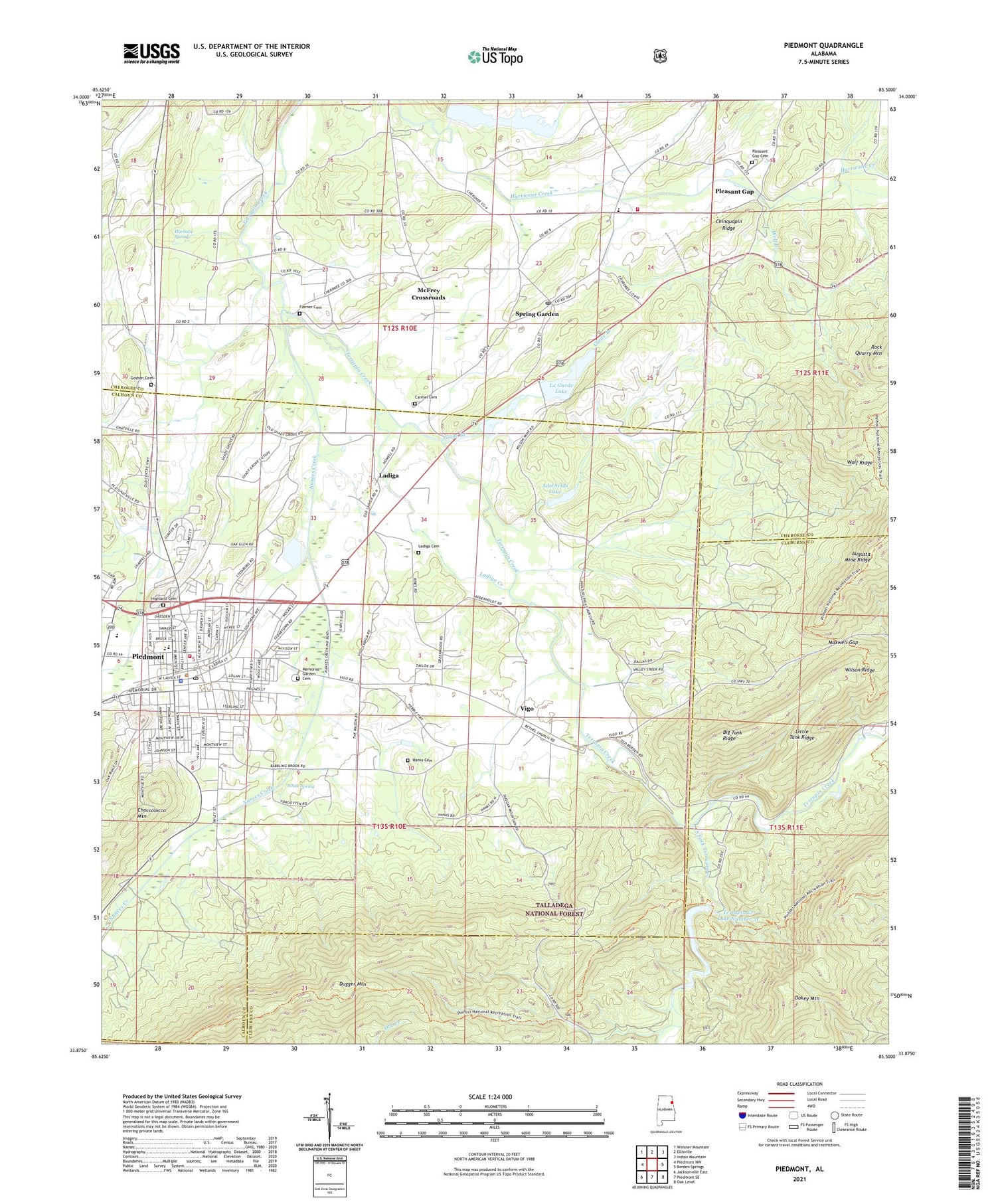
Piedmont Alabama US Topo Map
Couldn't load pickup availability
Also explore the Piedmont Forest Service Topo of this same quad for updated USFS data
2024 topographic map quadrangle Piedmont in the state of Alabama. Scale: 1:24000. Based on the newly updated USGS 7.5' US Topo map series, this map is in the following counties: Calhoun, Cherokee, Cleburne. The map contains contour data, water features, and other items you are used to seeing on USGS maps, but also has updated roads and other features. This is the next generation of topographic maps. Printed on high-quality waterproof paper with UV fade-resistant inks.
Quads adjacent to this one:
West: Piedmont NW
Northwest: Weisner Mountain
North: Ellisville
Northeast: Indian Mountain
East: Borden Springs
Southeast: Oak Level
South: Piedmont SE
Southwest: Jacksonville East
This map covers the same area as the classic USGS quad with code o33085h5.
Contains the following named places: Aderholds Lake, Augusta Mine Ridge, Bethel Church, Bethune High School, Big Tank Ridge, Carmel Presbyterian Church, Carmel Presbyterian Church Cemetery, Chinquapin Ridge, Church of Christ, Church of God, City of Piedmont, Dailey, Dailey Street Baptist Church, Dugger Mountain, Dugger Mountain Lookout Tower, Faith Church, Farmer Cemetery, First Baptist Church, First Presbyterian Church, First United Methodist Church, Frog Creek, Glade Branch, Goshen, Goshen United Methodist Church, Goshen Valley Cemetery, Goshen Valley Church, Greenwood, Greenwood Elementary School, Hanks Cemetery, Harbour Spring, Highland Cemetery, Jaycee Park, La Garde Lake, Ladiga, Ladiga Cemetery, Ladiga Creek, Ladiga School, Lagarde Number 1 Dam, Lagarde Number 1 Lake, Lagarde Number 2 Dam, Lagarde Number 2 Lake, Liberty Baptist Church, Little Tank Ridge, Maxwell Gap, McFrey Crossroads, Mill Creek, Millers Poultry Farm Number 2, Nances Creek, Northside Baptist Church, Oakey Mountain, Old Goshen Center, Philadelphia, Philadelphia Baptist Church, Philadelphia School, Piedmont, Piedmont City Hall, Piedmont Congregational Holiness Church, Piedmont Fire Department, Piedmont High School, Piedmont Hospital, Piedmont Memory Gardens Cemetery, Piedmont Police Department, Piedmont Post Office, Piedmont Rescue Squad, Piedmont Shopping Center, Pleasant Gap, Pleasant Gap Cemetery, Pleasant Gap Church, Pleasant Gap School, Saint Joachim Catholic Church, Shady Grove Church, South Fork Terrapin Creek, Southside Elementary School, Spring Garden, Spring Garden Census Designated Place, Spring Garden High School, Spring Garden Methodist Church, Spring Garden Post Office, Spring Garden Volunteer Fire Department, Terrapin Creek Lake Number 31, Terrapin Creek Lake Number 8, Terrapin Creek Watershed Dam Number 31, Terrapin Creek Watershed Dam Number 8, Terrapin Creek Watershed Dam Number 9, Vigo, White Spring, Willard School, Wilson Ridge, Wolf Branch, Wolf Ridge, WPID-AM (Piedmont), ZIP Code: 36272


