MyTopo
Rogersville Alabama US Topo Map
Couldn't load pickup availability
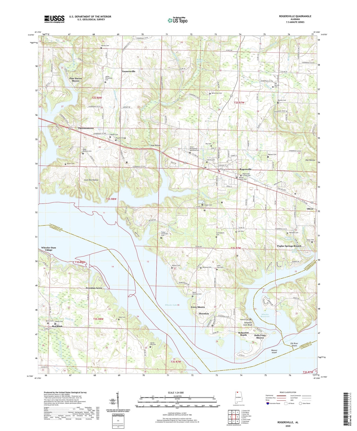
2024 topographic map quadrangle Rogersville in the state of Alabama. Scale: 1:24000. Based on the newly updated USGS 7.5' US Topo map series, this map is in the following counties: Lauderdale, Lawrence, Limestone. The map contains contour data, water features, and other items you are used to seeing on USGS maps, but also has updated roads and other features. This is the next generation of topographic maps. Printed on high-quality waterproof paper with UV fade-resistant inks.
Quads adjacent to this one:
West: Wheeler Dam
Northwest: Center Hill
North: Lexington
Northeast: Union Hill
East: Cairo
Southeast: Hillsboro
South: Courtland
Southwest: Town Creek
This map covers the same area as the classic USGS quad with code o34087g3.
Contains the following named places: Berry Cemetery, Blowing Spring, Butler Cemetery, Cooper Cemetery, Corn Island, Cox Cemetery, Coxs Bar, Cunningham Cemetery, Dean - McNairy Cemetery, Dells Vista Shores, East End High School, Elk River, Elk River Shoals, Elk River View, Estep, Ferry Shores, First Baptist Church, First Bars, First Creek, Freeman Acres, Fuqua - Sturdivant Cemetery, Gibson Cemetery, Good Springs Missionary Baptist Church, Gourd Island, Graceland Park, Haraway Cemetery, Harraway School, Harvey Cemetery, Howard Island, Ingram Cemetery, Jackson Chute, James Whitehead Cemetery, Lambs Ferry, Lauderdale County High School, Liberty Cemetery, Little Zion Cemetery, Little Zion Church, Lock One Hollow, McCartney Cemetery, McNairy School, Miller Cemetery, Moody Branch, Mount Olive, Mount Olive Cumberland Presbyterian Church, Mount Olive School, Nance - Simmons Cemetery, Nances Reef, Neeley Branch, New Mount Bethel United Methodist Church, Nugent Branch, Oak Grove School, Old Mount Bethel Cumberland Presbyterian Church, Old Romine Cemetery, Oliver, Oliver - Bedingfield Memorial Cemetery, Oliver Church of Christ, Oliver School, Page Branch, Perry Branch, Pine Haven Shores, Pinedale Home Sites, Poplar Spring, Poplar Springs Branch, Ramblewood Shores, Ray Cemetery, Red Bank, Red Bank Missionary Baptist Church, Red Bank School, Roberson Beach, Rogersville, Rogersville Church, Rogersville Civitan Cemetery, Rogersville Police Department, Rogersville Post Office, Rogersville Public Library, Rogersville Volunteer Fire Department, Romain School, Romine, Romine Cemetery, Romine Church of Christ, Saltpeter Cave Bluff, Sedge Grass Island, Sharps Shores, Simpson Branch, Slop Hollow, Southside Church, Spring Hill Cemetery, Sweetgum Island, Thompson Branch, Thornton, Thornton Cemetery, Thorntontown, Tick Island, Toonersville, Town of Rogersville, Wallace Cemetery, Warmack Cemetery, Warmack Spring, Watkins Cemetery, Weaver Branch, Weaver Cemetery, Weaver Family Cemetery, Weaver Island, West Rogersville Church, Wheeler Dam Subdivision, Yates Cemetery, York Branch, ZIP Code: 35652