MyTopo
Smiths Station Alabama US Topo Map
Couldn't load pickup availability
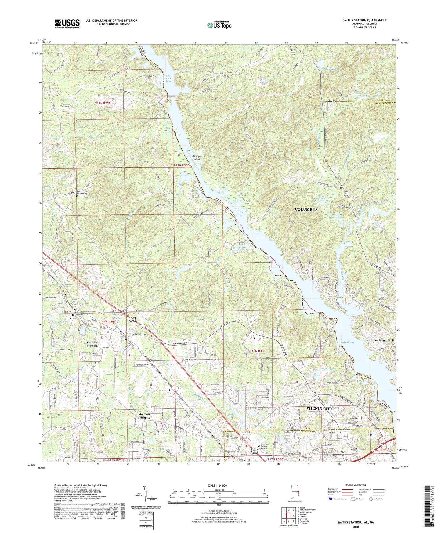
2024 topographic map quadrangle Smiths Station in the states of Alabama, Georgia. Scale: 1:24000. Based on the newly updated USGS 7.5' US Topo map series, this map is in the following counties: Lee, Muscogee, Harris, Russell. The map contains contour data, water features, and other items you are used to seeing on USGS maps, but also has updated roads and other features. This is the next generation of topographic maps. Printed on high-quality waterproof paper with UV fade-resistant inks.
Quads adjacent to this one:
West: Bleecker
Northwest: Beulah
North: Bartletts Ferry Dam
Northeast: Mulberry Grove
East: Fortson
Southeast: Columbus
South: Phenix City
Southwest: Crawford
Contains the following named places: Bethany Baptist Church, Bethel Mission, Bethel Mission Cemetery, Biggers Lake, Blackmon Dam, Blackmon Lake, Byrd Island, C L Mullins Dam, Carriage Hill, City of Smiths Station, Clyde Powell Dam, Columbus Fire Department and Emergency Medical Services Station 14, Community Church, Cornerstone Church, Douglas Creek, Fullers Lakes, Glenwood School, Glovers Church, Goat Rock Dam, Goat Rock Recreation Area, Green Island Hills, Green Island Hills Golf Course, H H Webb Dam, Heiferhorn Creek, Jack Hughston Memorial Hospital, Jesus Christ Church, Jones Light Aviation Airport, Jordan Company Dam, Jordan Company Lake, Lake Clarmar, Lake Manderly, Lake Manderly Dam, Lake Oliver, Lake Thel, Lake Thel Dam, Lake View Memory Gardens, Lakeview Golf Course, Lakeview Park, Lee County International Raceway, Monterey Heights, Mount Olive Missionary Church, Mount Zion Cemetery, Mount Zion Church, Mullins Lake, New Nelius Church, Oliver Dam, Phenix City Fire Department Station 4, Philadelphia Baptist Church, Philadelphia Cemetery, Phillips Island, Piney Grove Census Designated Place, Powell Lake, Price Road Baptist Church, Rock Creek, Rock Creek Cove, Saint Stephens Church, Shingle Town, Smith Station School, Smiths Dam, Smiths Lake, Smiths Station, Smiths Station Fire and Rescue Station 2, Smiths Station High School, Smiths Station Post Office, Soap Creek, Standing Boy Creek, Summerville, Summerville Assembly of God Church, Turkey Creek, Twin Lakes, Union Grove United Methodist Church, Waller Lake, Waller Lake Dam, Walts Landing, Webbs Pond, Wrights Lakes, ZIP Codes: 31904, 36877