MyTopo
Trafford Alabama US Topo Map
Couldn't load pickup availability
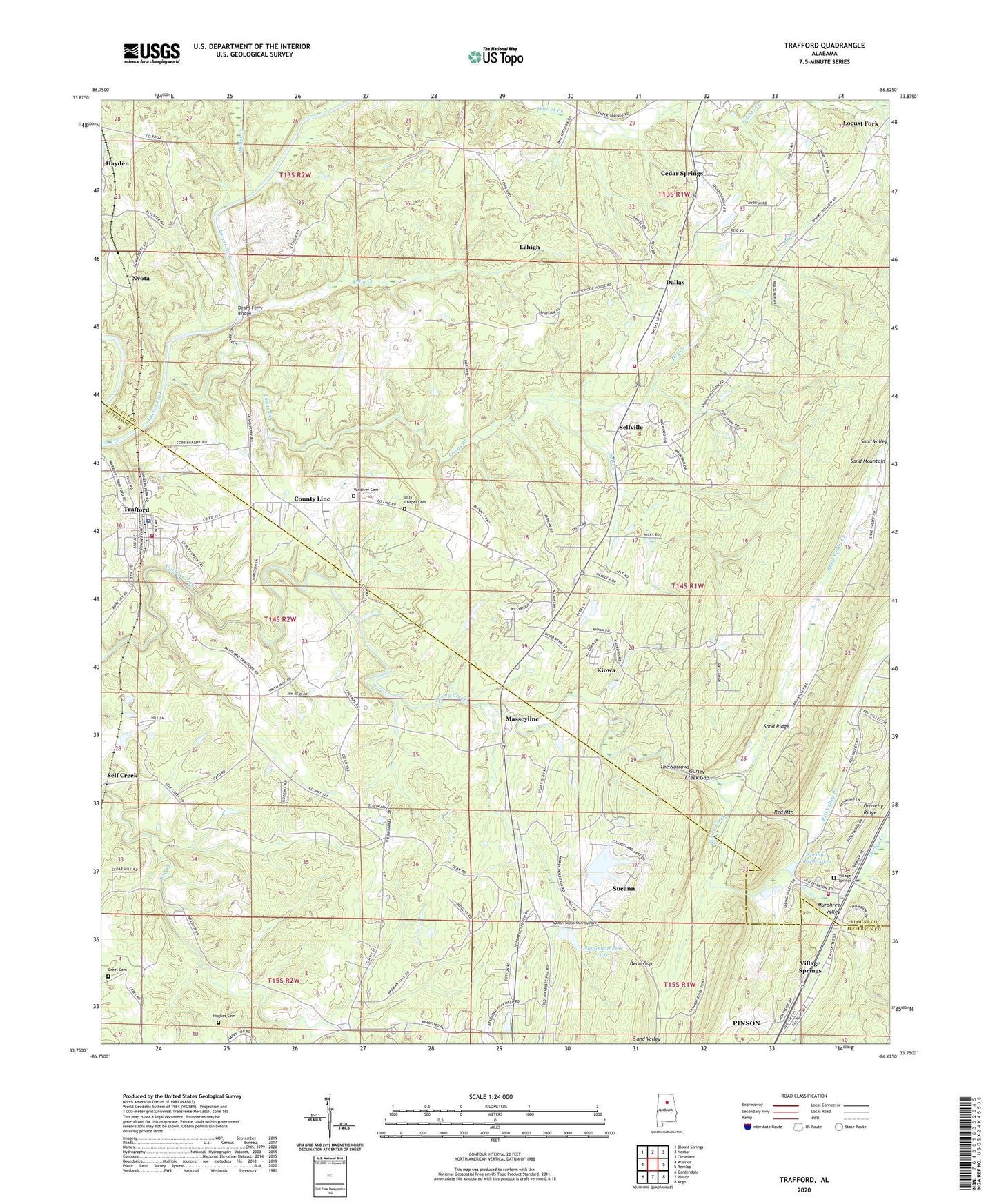
2024 topographic map quadrangle Trafford in the state of Alabama. Scale: 1:24000. Based on the newly updated USGS 7.5' US Topo map series, this map is in the following counties: Blount, Jefferson. The map contains contour data, water features, and other items you are used to seeing on USGS maps, but also has updated roads and other features. This is the next generation of topographic maps. Printed on high-quality waterproof paper with UV fade-resistant inks.
Quads adjacent to this one:
West: Warrior
Northwest: Blount Springs
North: Nectar
Northeast: Cleveland
East: Remlap
Southeast: Argo
South: Pinson
Southwest: Gardendale
This map covers the same area as the classic USGS quad with code o33086g6.
Contains the following named places: Bethel United Methodist Church, Bethlehem Church, Black Creek Number 1 Mine, Bradford, Bradford Church, Bradford Slope Mine, Bradford United Methodist Church, Brentwood, Cedar Springs, Compton, County Line, County Line Missionary Baptist Church, County Line Town Hall, Creel Cemetery, Cumberland Dam, Dallas, Dallas - Selfville Volunteer Fire Department, Dallas Church, Dean Gap, Deans Ferry Bridge, Dixiana Post Office, Dry Creek, Good News Church, Gurley, Gurley Creek Gap, Hayes Creek, Higginbothams Lake, Holston Chapel, Hopewell Church, Hopewell Lake, Huffstufer Mine, Hughes Cemetery, Hughes Chapel, Indio Mine, Jefferson Hughes Church, Johns Mine, Johnson Elementary School, Kelly Creek, Kimberly-Morris Division, Kiowa, Lake Sueann, Lake Sueann Dam, Lehigh, Lilly Chapel, Lilly Chapel Cemetery, Locust Fork Division, Longs Branch, Longs Ford, Masseyline, Masseyline Church, Murphree Valley, Nyota, Nyota Mine, Philadelphia Church, Pleasant Grove Church, Red Valley Branch, Remlap Volunteer Fire Department Station 2, Revelation Church, Rio Dell Mine, Sand Ridge, Sand Valley Creek, Self Creek, Selfville, Selfville Church, Smith Mill, South Carbon Mine, Spring Valley Lakes, Sterling School, Sueann, The Narrows, Thermal, Thermal Number 1 Mine, Town of County Line, Town of Trafford, Trafford, Trafford Baptist Church, Trafford Church of God, Trafford City Hall, Trafford Elementary School, Trafford Fire Department, Trafford Police Department, Trafford Post Office, Upper Creek Mine, Vandiver Cemetery, Village Springs, Village Springs Cemetery, Village Springs Church, Wilson Number 1 Mine, Woodhaven, Worthington Ore Mines, Youngblood Chapel, ZIP Code: 35172