MyTopo
Warrior Alabama US Topo Map
Couldn't load pickup availability
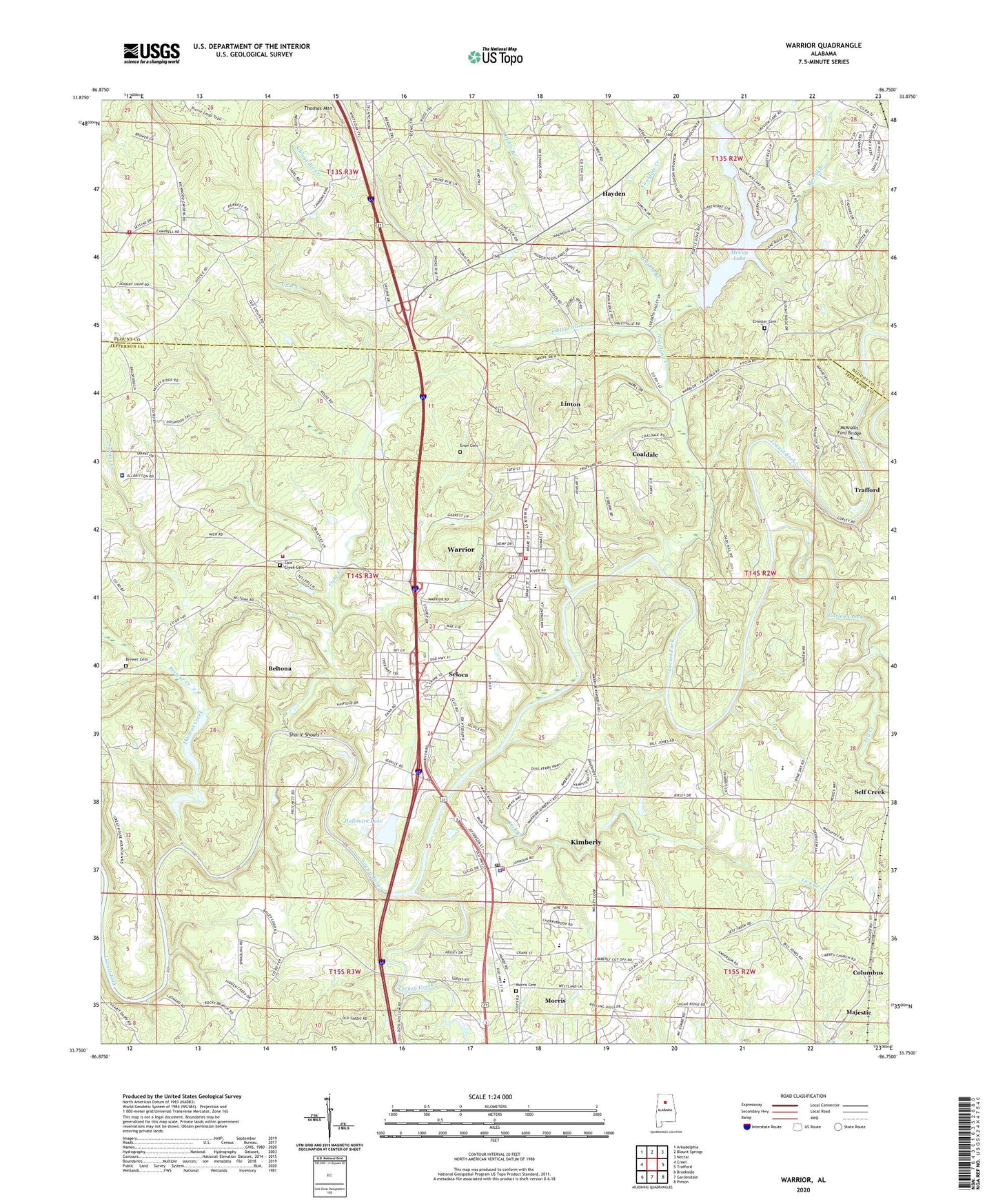
2024 topographic map quadrangle Warrior in the state of Alabama. Scale: 1:24000. Based on the newly updated USGS 7.5' US Topo map series, this map is in the following counties: Jefferson, Blount. The map contains contour data, water features, and other items you are used to seeing on USGS maps, but also has updated roads and other features. This is the next generation of topographic maps. Printed on high-quality waterproof paper with UV fade-resistant inks.
Quads adjacent to this one:
West: Creel
Northwest: Arkadelphia
North: Blount Springs
Northeast: Nectar
East: Trafford
Southeast: Pinson
South: Gardendale
Southwest: Brookside
This map covers the same area as the classic USGS quad with code o33086g7.
Contains the following named places: Arnold Pit Mine, Azbeth Church, Beltona, Blackcat Mine, Bradford Health Services Warrior Residential Hospital Treatment Center, Brake, Brake Ferry, Brake Mine, Brewer Cemetery, Brewer Creek, Bryan School, Cain Creek Cemetery, Cain Creek Church, Calvary Church, Cane Creek, Cane Creek Elementary School, Cane Creek Volunteer Fire Department, Capricorn Mine, Carl Mine, Case Rock Mine, Cherokee Estates, City of Kimberly, City of Warrior, Coaldale, Coaldale Creek, Columbus, Country Haven, Dixiana Mine, Doss Ferry, Double Branch, Elvesta Drift Mine, Elvester Baptist Church, Elvester Cemetery, Enon Cemetery, Gurley Creek, Gurley Creek Mine, Haig Church, Hallmark Lake, Hallmark Lake Dam, Higginbotham Mine, Hogeland Creek, Jefferson Mines, Jett Mine, Kimberly, Kimberly Elementary School, Kimberly Fire Department, Kimberly Number 2 Slope Mine, Kimberly Number 3 Slope Mine, Kimberly Number 4 Mine, Kimberly Police Department, Kimberly Post Office, Kimberly Town Hall, Langley Mine, Langley Number 3 Mine, Liberty Church, Lick Creek, Linton, Macknally Ford, Majestic High School, Majestic Mine, Marshall McCay Lake Dam, Masel Mine, McCay Lake, McKnally Ford Bridge, Merrill Branch, Morris Cemetery, Mortimer Jordan High School, Mount High Church, Mount High Fire and Rescue Station 1, Mount High School, Mountain Woods Lake Dam, New Bethel Elementary School, Old Butler Number 12 Mine, Parker Hudson Estates, Pierson Mine, Posey Mill, Prichette, Pritchett Number 1 Drift Mine, Riverside Mine, Sardis Church, Sardis School, Self Creek, Self Creek Mine, Seloca, Sharit Shoals, Sibleyville Creek, Skyview Lake, Stewart Church, Thomas Creek, Thomas Mountain, Turkey Creek, Warrior, Warrior City Hall, Warrior Division, Warrior Elementary School, Warrior Fire Department, Warrior High School, Warrior Middle School, Warrior Mine, Warrior Police Department, Warrior Post Office, Warrior School, Watt Mine, Watts Union Church, Zola Baptist Church, ZIP Codes: 35091, 35180