MyTopo
Vandiver Alabama US Topo Map
Couldn't load pickup availability
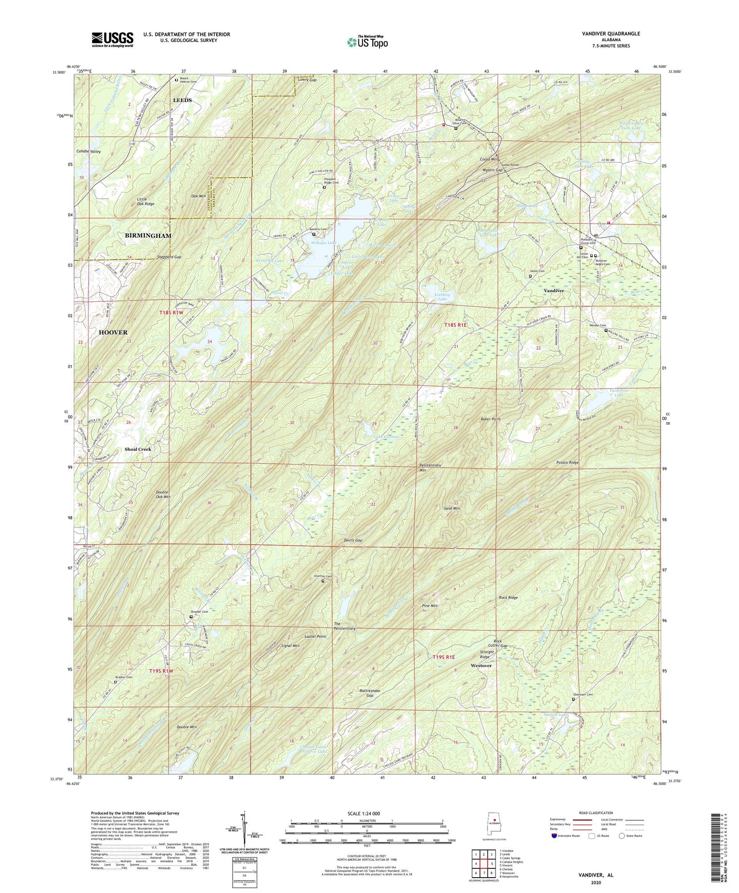
2024 topographic map quadrangle Vandiver in the state of Alabama. Scale: 1:24000. Based on the newly updated USGS 7.5' US Topo map series, this map is in the following counties: Shelby, Jefferson. The map contains contour data, water features, and other items you are used to seeing on USGS maps, but also has updated roads and other features. This is the next generation of topographic maps. Printed on high-quality waterproof paper with UV fade-resistant inks.
Quads adjacent to this one:
West: Cahaba Heights
Northwest: Irondale
North: Leeds
Northeast: Cooks Springs
East: Vincent
Southeast: Harpersville
South: Westover
Southwest: Chelsea
This map covers the same area as the classic USGS quad with code o33086d5.
Contains the following named places: Alpines Lakes, Anders Branch, Baker Point, Big Branch, Bob Hood Branch, Brasher Branch, Brasher Cemetery, Brashers Chapel Church, Cahaba Girl Scout Council Lake, Cahaba Valley Country Club, Calvary Church, Cedar Lake, Chelsea Division, Chelsea Game Preserve Lake, Chelsea Game Preserve Lake Dam, Coosa Mountain, Coosa Tunnel, Crystal Lake, Davis Lake Dam Number Two, Devils Gap, Double Oak Mountain, Dunavant, Dunnavant Census Designated Place, Dunnavant Faith Chapel, Dunnavant Volunteer Fire Department, Ebenezer Cemetery, Ebenezer Church, Falkner School, Faulkner Church, Finger Lake, Finger Lake Dam, Great Pine Lake, Hollis Cemetery, Hollybrook Lake, Holmes Branch, Indian Creek, Jim Pearson School, Kendrix Cemetery, Kerscoha Lake, Lake Gorman, Lake Wehapa Dam, Laurel Point, Little Deer Lakes, Lowry Gap, Mirror Lakes, Moore Lake, Mount Hebron Baptist Church, Mount Hebron Cemetery, Mount Hebron School, Mount Olive Cemetery, Mount Olive Freewill Baptist Church, Mountain View Lake, North Valley View Lake, North Valley View Lake Dam, Overton Cemetery, Penitentiary Mountain, Pine Mountain, Pleasant Grove Cemetery, Pleasant Grove Church, Pleasant Ridge Cemetery, Pleasant Ridge Church, Pleasant Site Church, Pless Lake Dam, Potato Ridge, Rattlesnake Gap, Rock Cutter Gap, Rock Ridge, Sand Mountain, Saunders Lake Dam, Shelton Lake, Shelton Lake Dam, Shephard Branch, Shephard Gap, Shoal Creek Census Designated Place, Shoal Creek Country Club, Shoal Creek Golf Course, Signal Mountain, Signal Mountain Lookout Tower, Smyer Lake Dam Number Two, Smyers Lake Dam Number One, Spouting Spring Branch, Spring Lake, Straight Ridge, The Penitentiary, Tunnel Branch, Twin Pine Lake, Union Hill Cemetery, Union Hill Freewill Baptist Church, Valley Lake, Valley View Lake, Valley View Lake Dam, Vandiver, Vandiver Census Designated Place, Vandiver Elementary School, Vandiver Negro Cemetery, Vandiver Post Office, Vandiver Volunteer Fire and Rescue Department Station 1, Wehapa Lake, Weldon Branch, Weldon Cemetery, Wyatts Gap, Yielding Lake, Yielding Lake Dam, ZIP Code: 35147