
MyTopo
Casa Grande East Arizona US Topo Map
Couldn't load pickup availability
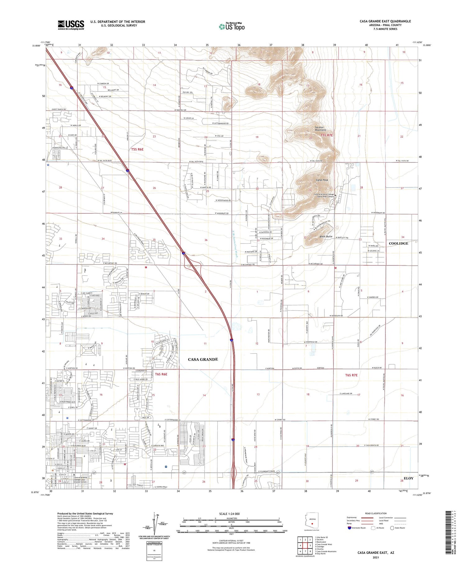
2021 topographic map quadrangle Casa Grande East in the state of Arizona. Scale: 1:24000. Based on the newly updated USGS 7.5' US Topo map series, this map is in the following counties: Pinal. The map contains contour data, water features, and other items you are used to seeing on USGS maps, but also has updated roads and other features. This is the next generation of topographic maps. Printed on high-quality waterproof paper with UV fade-resistant inks.
Quads adjacent to this one:
West: Casa Grande West
Northwest: Gila Butte SE
North: Sacaton
Northeast: Blackwater
East: Coolidge
Southeast: Eloy North
South: Casa Grande Mountains
Southwest: Chuichu
This map covers the same area as the classic USGS quad with code o32111h6.
Contains the following named places: Banner Casa Grande Medical Center, Black Butte, Burris Park, Cactus Middle School, Casa Grande Church of Christ, Casa Grande City Hall, Casa Grande Fire Department Station 502, Casa Grande Police Department, Casa Grande Seventh Day Adventist Church, Casa Grande Union High School, Casa Verde Estates Mobile Home Park, Casa Verde High School, Central Arizona College Casa Grande Center, Central Arizona College Signal Peak Campus, Central Arizona College Signal Peak Campus Bradley Sizer Jr Center for Business Studies, Central Arizona College Signal Peak Campus C Leroy Hoyt Hall Science - Engineering Building, Central Arizona College Signal Peak Campus Don P Pence Center for Visual and Performing Arts, Central Arizona College Signal Peak Campus Filberto Rudolfo Ortiz Building, Central Arizona College Signal Peak Campus George Young Activity Center, Central Arizona College Signal Peak Campus Gloria R Sheldon University Center, Central Arizona College Signal Peak Campus Interactive Learning Center, Central Arizona College Signal Peak Campus James T O'Neil Administration Hall, Central Arizona College Signal Peak Campus Leslie A Wakefield Center for Health and Home, Central Arizona College Signal Peak Campus Library and Communications Building, Central Arizona College Signal Peak Campus Mel A Everingham Student Center, Central Arizona College Signal Peak Campus Paul Pearce Center for Technological Studies, Central Arizona College Signal Peak Campus Student Services Center, Cholla Elementary School, Christian Church of Casa Grande, Coolidge High School Success Center, Cornerstone Community Church, Cottonwood Elementary School, Desert Willow Elementary School, Desert Winds Learning Center, Dorothy Powell Senior Adult Center, East Park, Elliott Park, Evergreen Elementary School, First Assembly of Casa Grande, First Presbyterian Church, Fye Airstrip, Garnet of Casa Grande Assisted Living Community, Grace Baptist Church, Gypsum Mines, Harvest Family Church, Ironwood Elementary School, Kingdom Hall of Jehovahs Witnesses, KWLL-AM (Casa Grande), Lake in the Desert, Len Colla Recreation Center, McCartney Ranch Elementary School, New Beginnings Church of the Nazarene, Oniel Park, Palm Creek Golf Course, Palm Creek Recreational Vehicle Resort, Palm Island Family Aquatics Center, Pinal County Casa Grande Health Department, Pinal County Sheriff's Office Casa Grande Region C, Rancho Grande Park, Regional Fire Rescue, Saint Michael and All Angels Liberal Catholic Cathedral, Saint Peter's Episcopal Church, Signal Peak, Storey Road Underpass, Sun Life Family Health Center, The Church of Jesus Christ of Latter Day Saints, Trinity Lutheran Church, Trinity Southern Baptist Church, Union High School, United Methodist Church of Casa Grande, Val Vista Recreational Vehicle Park, Victory Baptist Church, Villago Middle School, Vista Grande High School, ZIP Codes: 85122, 85194


