MyTopo
Davis Dam Arizona US Topo Map
Couldn't load pickup availability
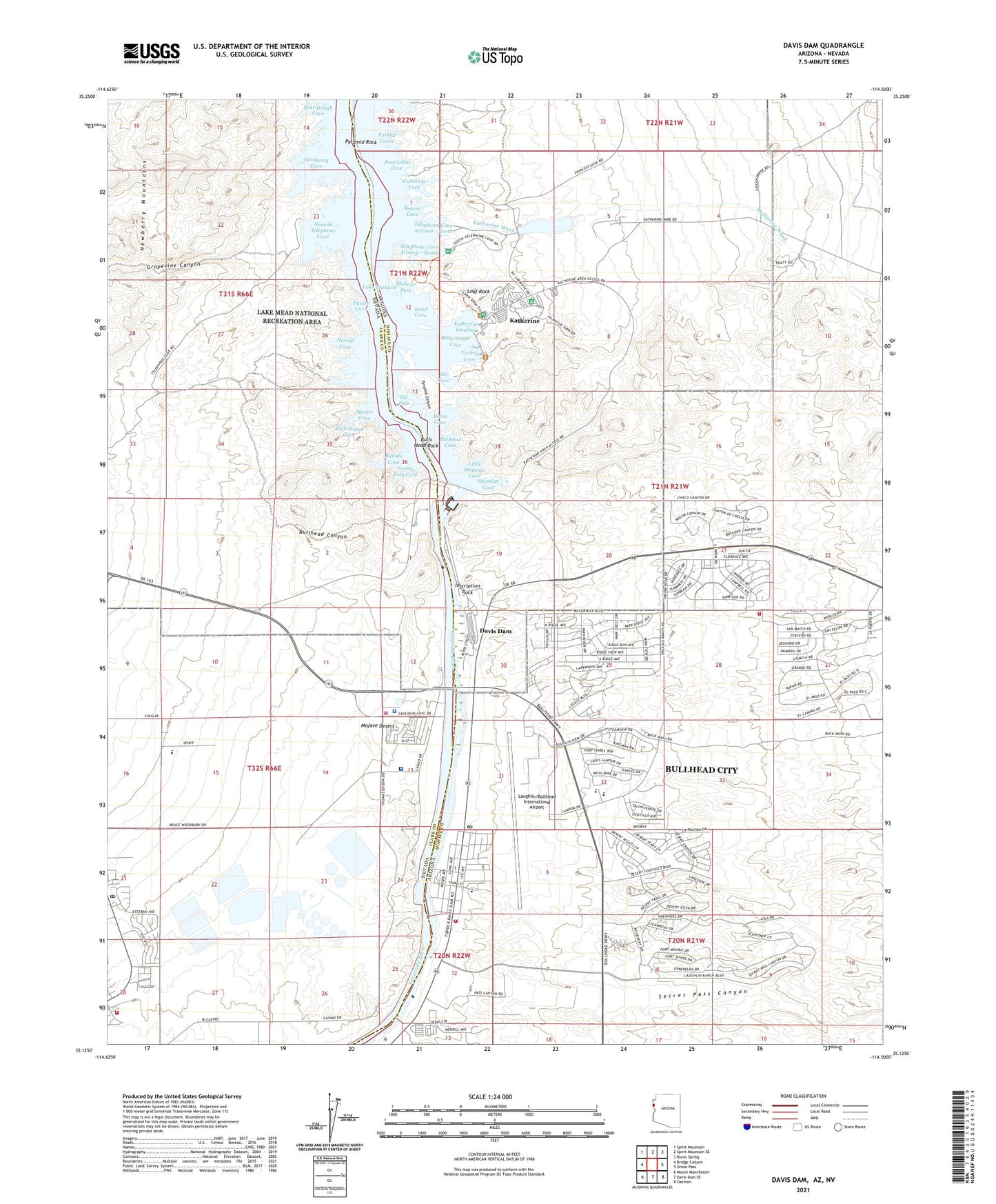
2021 topographic map quadrangle Davis Dam in the states of Arizona, Nevada. Scale: 1:24000. Based on the newly updated USGS 7.5' US Topo map series, this map is in the following counties: Mohave, Clark. The map contains contour data, water features, and other items you are used to seeing on USGS maps, but also has updated roads and other features. This is the next generation of topographic maps. Printed on high-quality waterproof paper with UV fade-resistant inks.
Quads adjacent to this one:
West: Bridge Canyon
Northwest: Spirit Mountain
North: Spirit Mountain SE
Northeast: Burns Spring
East: Union Pass
Southeast: Oatman
South: Davis Dam SE
Southwest: Mount Manchester
Contains the following named places: Arrowhead Cove, Beaver Cove, Bergemeyer Cove, Bullhead Canyon, Bullhead City, Bullhead City Airport, Bullhead City Fire Department Station 2, Bullhead City Fire Department Station 3, Bullhead Cove, Bulls Head Dam Site, Bulls Head Rock, Cabinsite Cove, Carefree Resort Mobile Home Park, Clark County Fire Department Station 76, Clark County Fire Department Station 85, Davis Cove, Davis Dam, Davis Dam Post Office, Dead Elephant Cove, Desert Shores Community Baptist Church, Evaporation Pond Number 6A Dam, Evaporation Pond Number 6B Dam, Evaporation Pond Number 6C Dam, Evaporation Pond Number Five Dam, Evaporation Pond Number Four Dam, Evaporation Pond Number Three Dam, Evaporation Pond Number Two Dam, Forbay Bridge, Forked Coves, Grapevine Canyon, Homestake Group Mine, Inscription Rock, Jackrabbit Cove, Katherine, Katherine Census Designated Place, Katherine Extension Mine, Katherine Landing, Katherine Mine, Katherine Ranger Station, Katherine Wash, Lake Mohave Recreation Site Kathrine Landing, Lake Mohave Resort, Las Vegas Metropolitan Police Department - Laughlin Substation, Laughlin, Laughlin Census Designated Place, Laughlin Community Resources Building, Laughlin Elementary School, Laughlin Government Center, Laughlin High School, Laughlin Metro Substation, Laughlin Middle School, Laughlin Park, Laughlin Post Office, Laughlin Ranch Golf Club, Laughlin/Bullhead International Airport, Little Stopsign Cove, Loaf Rock, Mikes Camp, Miners Cove, Mohave Generating Station, Mohave Generating Station Dam, Mohave Generating Station Reservoir, Mohave Pass, Montessori School House, Mountain View Elementary School, Mountain View Park, Navajo Cove, Nevada Telephone Cove, Newberry Cove, Ninety Foot Cove, Paiute Cove, Pyramid Canyon, Pyramid Rock, Rock House Cove, Ryolite Cove, Sand Cove, Sce Mohave Heliport, Secret Pass Canyon, Silver Creek, Silver Creek Wash, Ski Cove, Ski Pass, Sour Dough Cove, Spirit Mountain Activity Center, Sportsman Paradise County Campground, Stopsign Cove, Sunrise Elementary School, Telephone Cove Arizona - North, Telephone Cove Arizona - South, The Highway Station Post Office, Tristate, Turkey Cove, University Medical Center of Southern Nevada Laughlin Quick Care, US Bureau of Reclamation Davis Dam Power Plant Number 79, US National Park Service Katherine Landing Water Treatment Plant, Wiley Inspiration Mine, William Bennett Park, William G Bennett Elementary School