MyTopo
Hackberry Mountain Arizona US Topo Map
Couldn't load pickup availability
Also explore the Hackberry Mountain Forest Service Topo of this same quad for updated USFS data
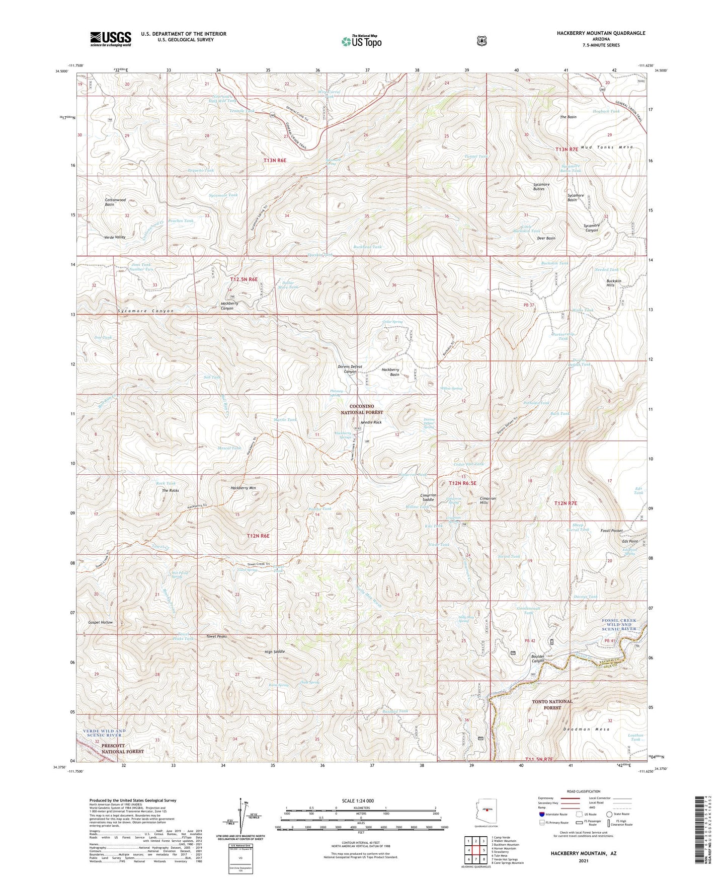
2021 topographic map quadrangle Hackberry Mountain in the state of Arizona. Scale: 1:24000. Based on the newly updated USGS 7.5' US Topo map series, this map is in the following counties: Yavapai, Gila. The map contains contour data, water features, and other items you are used to seeing on USGS maps, but also has updated roads and other features. This is the next generation of topographic maps. Printed on high-quality waterproof paper with UV fade-resistant inks.
Quads adjacent to this one:
West: Horner Mountain
Northwest: Camp Verde
North: Walker Mountain
Northeast: Buckhorn Mountain
East: Strawberry
Southeast: Cane Springs Mountain
South: Verde Hot Springs
Southwest: Tule Mesa
This map covers the same area as the classic USGS quad with code o34111d6.
Contains the following named places: Boulder Canyon, Brushy Prong, Buck Tank, Buckhead Tank, Buckskin Hills, Buckskin Tank, Bull Run Tank, Burnt Spring, Buzzard Tank, Cedar Flat Tank, Cedar Spring, Chalk Spring, Childs, Cimarron Creek, Cimarron Hills, Cimarron Saddle, Cimarron Spring, Cimarron Tank, Cottonwood Well, Crissman Spring, Daveys Tank, Deadman Mesa, Deer Basin, Doe Tank, Doeskin Tank, Dollar More Tank, Dorens Defeat Canyon, Dorens Defeat Spring, Dorens Defeat Tank, Eds Point, Eds Point Spring, Eds Point Tank, Eds Tank, Fossil Creek Wild and Scenic River, Fossil Pocket, Goodenough Tank, Hackberry Basin, Hackberry Canyon, Hackberry Mountain, Hackberry Springs, High Saddle, Hogback Tank, Holdup Tank, Jims Tank Number Two, Kiki Tank, Little Buckskin Tank, Louthan Tank, Mescal Tank, Mud Tanks Mesa, Mud Tanks Trail Fifty, Myrtle Tank, Needed Tank, Needle Rock, Nine and a Half Mile Tank, Pambo Tank, Partnership Tank, Peaches Tank, Pequeno Tank, Phroney Spring, Pothole Tank, Potholes Tank, Rim Tank, Rock Tank, Sally May Spring, Sally May Tank, Sally May Wash, Sheep Corral Tank, Sierra Tank, Sob Tank, Sycamore Basin, Sycamore Basin Tank, Sycamore Buttes, Sycamore Spring, Sycamore Tank, Tenmile Tank, The Basin, The Rocks, Towel Creek Trail, Towel Peaks, Towel Peaks Tank, Towel Spring, Towel Tank, Trail Tank, Tunnel Tank, Verde Valley, Viede Tank, Walts Tank, Wet Prong Spring, Willow Spring, Willow Tank, Wire Corral Tank