MyTopo
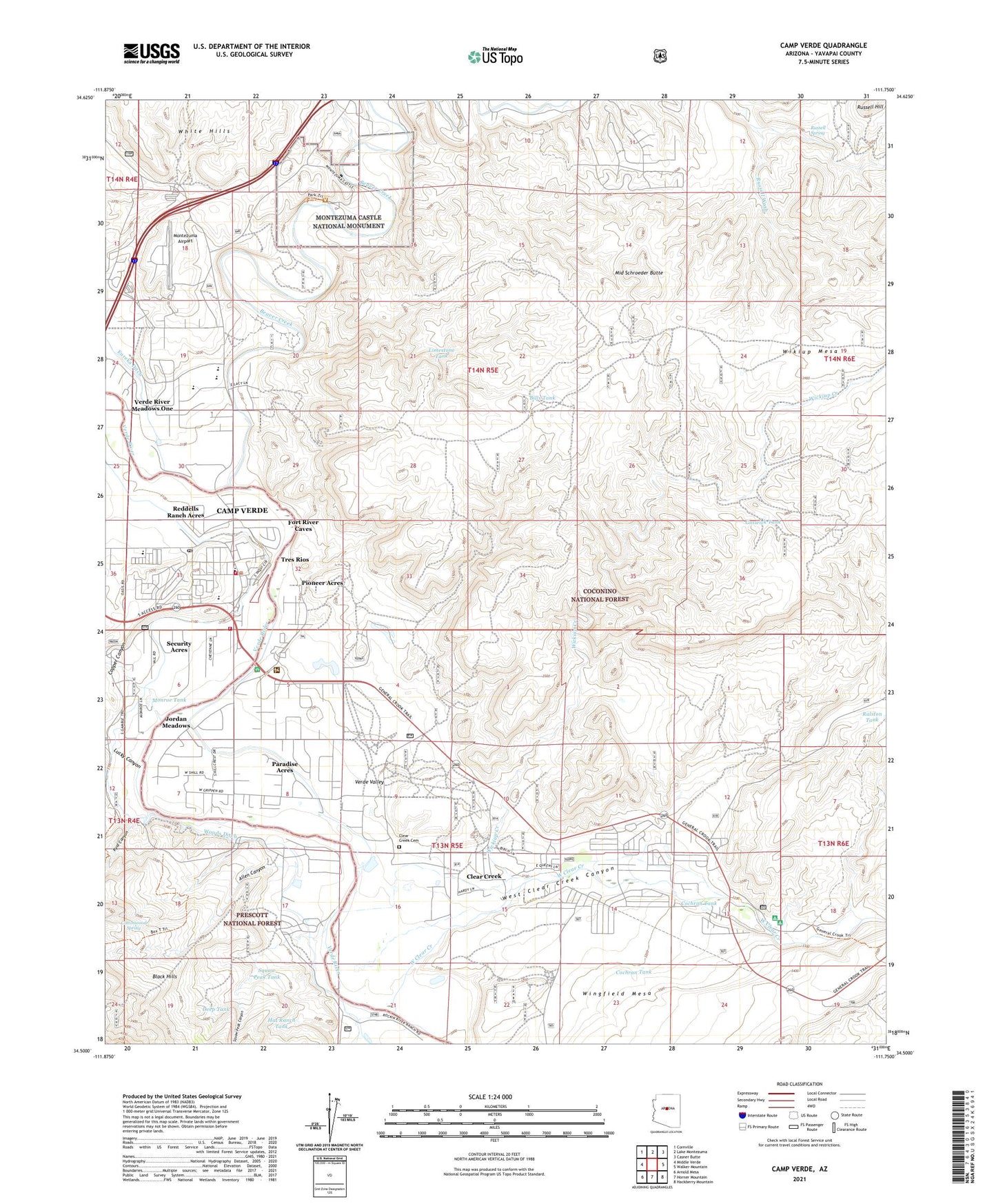
Camp Verde Arizona US Topo Map
Couldn't load pickup availability
Also explore the Camp Verde Forest Service Topo of this same quad for updated USFS data
2023 topographic map quadrangle Camp Verde in the state of Arizona. Scale: 1:24000. Based on the newly updated USGS 7.5' US Topo map series, this map is in the following counties: Yavapai. The map contains contour data, water features, and other items you are used to seeing on USGS maps, but also has updated roads and other features. This is the next generation of topographic maps. Printed on high-quality waterproof paper with UV fade-resistant inks.
Quads adjacent to this one:
West: Middle Verde
Northwest: Cornville
North: Lake Montezuma
Northeast: Casner Butte
East: Walker Mountain
Southeast: Hackberry Mountain
South: Horner Mountain
Southwest: Arnold Mesa
This map covers the same area as the classic USGS quad with code o34111e7.
Contains the following named places: Allen Canyon, Arizona Highway Maintenance Yard, Beaver Creek, Bills Tank, Buffalo Run Mobile Home Park, Calvary Chapel of Camp Verde, Camp Verde, Camp Verde Administrative Site, Camp Verde Airport, Camp Verde Christian Church, Camp Verde Elementary School, Camp Verde Fire District Station 81, Camp Verde Fire District Station 83, Camp Verde First Southern Baptist Church, Camp Verde High School, Camp Verde Marshal's Office, Camp Verde Middle School, Camp Verde Military Reservation, Camp Verde Mobile Home Park, Camp Verde Post Office, Camp Verde School, Camp Verde Seventh Day Adventist Church, Camp Verde United Christian School, Camp Verde United Methodist Church, Chester Newton Charter and Montessori School, Clear Creek, Clear Creek Campground, Clear Creek Cemetery, Cochran Tank, Copper Canyon, Cottonwood Spring, Country Estates, Deep Tank, Distant Drums Recreational Vehicle Resort, Fort River Caves, Fort Verde Estates, Fort Verde Garden Reservation, Goswick Tank, Hat Ranch Tank, Jordan Meadows, Krazy K Recreational Vehicle Park, Limestone Tank, Lower Camp Verde Indian Reservation, Lucky Canyon, Mesa Verde Estates, Middle Schroeder Butte, Monkey Tank, Monroe Tank, Montezuma Airport, Montezuma Castle National Monument, Mountain View Estates, New Beginnings Church of the Nazarene, Paradise Acres, Pioneer Acres, Ralston Tank, Reddells Ranch Acres, Russell Hill, Russell Spring, Ryal Canyon, Saint Frances Cabrini Catholic Church, Schroeder Tank, Security Acres, South Verde High School, Squaw Peak Canyon, Squaw Peak Tank, Stewards Tank, Sunnyside Charter and Montessori School, Test Hole Tank, The Church of Jesus Christ of Latter Day Saints, Town of Camp Verde, Tres Rios, Vee Seven Tank, Verde Ranger District Office, Verde River Meadows One, Verde Valley Church of Christ, Verde Vista Care and Rehabilitation Center, West Clear Creek, West Clear Creek Canyon, White Bridge Picnic Area, White Hill Tank, White Hills Mobile Home Park, Wickiup Creek, Wickiup Windmill, Wikiup Mesa, Wikiup Tank, Wingfield, Wingfield Mesa, Woods Ditch, Young Tank, Zane Grey Recreational Vehicle Park, ZIP Code: 86322