MyTopo
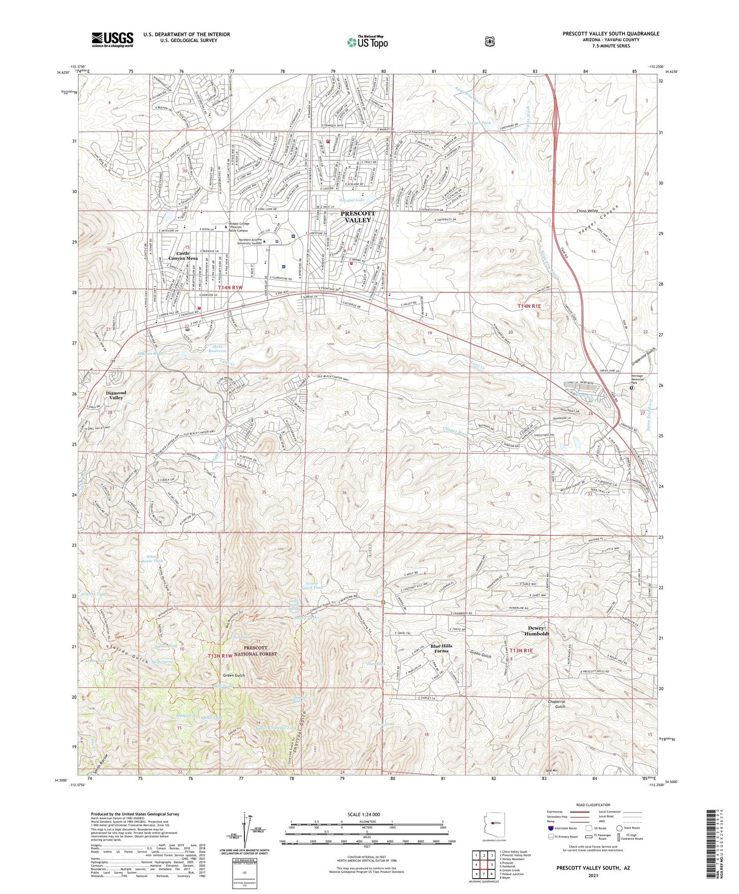
Prescott Valley South Arizona US Topo Map
Couldn't load pickup availability
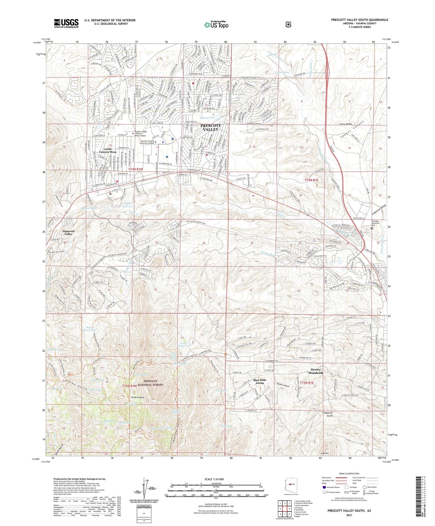
Also explore the Prescott Valley South Forest Service Topo of this same quad for updated USFS data
2023 topographic map quadrangle Prescott Valley South in the state of Arizona. Scale: 1:24000. Based on the newly updated USGS 7.5' US Topo map series, this map is in the following counties: Yavapai. The map contains contour data, water features, and other items you are used to seeing on USGS maps, but also has updated roads and other features. This is the next generation of topographic maps. Printed on high-quality waterproof paper with UV fade-resistant inks.
Quads adjacent to this one:
West: Prescott
Northwest: Chino Valley South
North: Prescott Valley North
Northeast: Hickey Mountain
East: Humboldt
Southeast: Mayer
South: Poland Junction
Southwest: Groom Creek
This map covers the same area as the classic USGS quad with code o34112e3.
Contains the following named places: Acorn Montessori School, Alberson Wash, Bethel Baptist Church, Blue Hills Farms, Bradshaw Mountain High School, Bradshaw Mountain Middle School, Brady Spring, Brushy Tank, Bull Tank, Bushy Tank, Castle Canyon Mesa, Central Arizona Fire and Medical Authority Fire Station 50, Central Arizona Fire and Medical Authority Fire Station 53, Chapel of the Valley, Charcoal Gulch, Charcoal Spring, Chino Valley, Christ Evangelical Lutheran Church, Clipper Well, Coyote Wash, Doodlebug Diggings, Emmanuel Lutheran Church, Excel Education Centers Prescott Valley, Fain Ranch, Fain Tank, Faith United Community Church, First Southern Baptist Church of Prescott Valley, Fountain of Life Community Church, Franklin Phonetic School, Glassford Hill Middle School, Good Samaritan Society - Prescott Valley, Granville Elementary School, Grapevine Gulch, Green Gulch Spring, Green Gulch Tank, Iglesia Casa de Oracion, Iron King Mine, James Well, Joes Tank, Johns Tank, Kingdom Hall of Jehovahs Witnesses, Kingdom Hall of Jehovahs Witnesses Mingus Mountain Congregation, Laestadian Lutheran Church of Prescott Valley, Lake Valley Elementary School, Liberty Traditional School, Lifepoint Church Bradshaw Mountain Campus, Lower Dam, Lynx Creek Dam, Mesa Reservoir, Mesa Reservoir Dam, Mingus View Presbyterian Church, Mountain Valley Church of God, Mountain Valley Regional Rehabilitation Hospital, Mountain View Elementary School, Northcentral University, Open Door Baptist Church, Park View Middle School, Praise Center of Prescott Valley, Prescott Country Club, Prescott Old Junior High School, Prescott Valley, Prescott Valley Airport, Prescott Valley Annex Post Office, Prescott Valley Christian Church, Prescott Valley Church of Christ, Prescott Valley Church of the Nazarene, Prescott Valley Community Center Park, Prescott Valley Plaza Shopping Center, Prescott Valley Police Department, Prescott Valley Recreation Area, Prescott Valley United Methodist Church, Prescott Wastewater Treatment Facility, Quail Tank, Robert Road Southern Baptist Church, Salida Spring, Salida Tank, Schreck Tank, Shadow Mountain Mobile Home Park, Smith Ravine, Spud Mountain, StoneRidge Golf Course, The Castle, Town and Country Valley Mall, Town of Prescott Valley, Trail Tank, Trinity Lutheran Church, Upper Charcoal Tank, Upper Dam, Upper Salida Tank, Victory Worship Bible Church, White Horse Tank, Yaeger Canyon, Yaeger Railroad Station, Yavapai College - Prescott Valley Campus, Yavapai Lake, Yavapai Regional Medical Center - Del E Webb Outpatient Center, Yavapai Regional Medical Center East Campus, Yeager, Yeager Tank