MyTopo
Mount Pleasant Arkansas US Topo Map
Couldn't load pickup availability
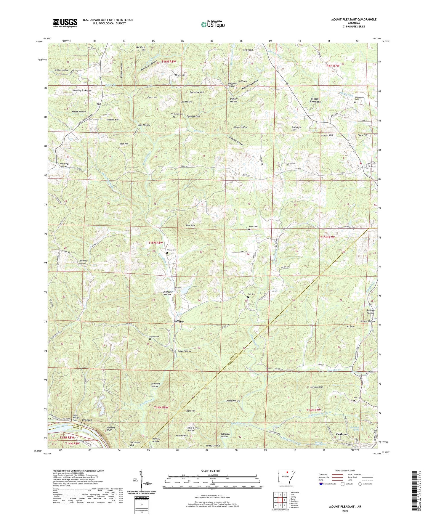
2024 topographic map quadrangle Mount Pleasant in the state of Arkansas. Scale: 1:24000. Based on the newly updated USGS 7.5' US Topo map series, this map is in the following counties: Izard, Independence, Stone. The map contains contour data, water features, and other items you are used to seeing on USGS maps, but also has updated roads and other features. This is the next generation of topographic maps. Printed on high-quality waterproof paper with UV fade-resistant inks.
Quads adjacent to this one:
West: Guion
Northwest: Melbourne
North: Zion
Northeast: Sidney
East: Sandtown
Southeast: Batesville
South: Bethesda
Southwest: Marcella
This map covers the same area as the classic USGS quad with code o35091h7.
Contains the following named places: Adeline Hill, Adler Hollow, Adler Hollow Mine, Alexander Hill, Anderson Prospect, Bailey Brooks Branch, Barksdale Mine, Bat Knob Hill, Bevans Prospect, Blowing Cave Creek, Blowing Cave Spring, Bob Wilson Prospect, Breeden Prospect, Brown Creek, Bryant Hollow, Buckalew Hill, C L Sanders Prospect, Calaway Prospect, Caraway Prospect, Cave Hill Mine, Cedar Grove School, Chappel Hollow, Chinquapin Cemetery, Clark Hill, Clubhouse Extension Mines, Clubhouse Mine, Clubhouse Spring, Clubhouse Spring Branch, Colley Branch, Craig Hill, Crocker, Crosby Hollow, Cummins Hollow, Cummins Hollow Mine, Cutter Mine, Dan Hollow, Dilliner Hollow, E D Winkle Prospect, E Winkle Prospect, Earl Collie Mine, Edmonson, Edwards Mine, Egard Hill, Egard Hollow, Ellen Clark Prospect, Felts Prospect, Fulbright Hill, Gid, Gid School, Groove Hollow, H J Ray Prospect, H M Tate Prospect, Haddock Prospect, Hall Prospect, Hankins Hollow, Hankins Hollow Mine, Hassel Cemetery, Helm Prospect, Hollawell Prospect, Izard County Christian School, Izard Mine, J P Barnes Prospect, J R Dobson Prospect, Jeff Hill, Johnson Hill Mine, Klondike Mine, L B Ray Prospect, L J Weaver Mine, Lafferty, Lafferty Community Church, Lafferty School, Lewis Prospect, Love Hollow, Love Prospect, M E Wilson Prospect, Macedonia Church, Macedonia Creek, Macedonia Hollow, Macedonia School, Manganese Field Mine, McConnell Mine, Miller Prospect, Moser Cemetery, Moser Hollow, Moser Prospect, Mount Etna, Mount Etna Mine, Mount Etna School, Mount Lebanon Church, Mount Pleasant, Mount Pleasant Elementary School, Mount Pleasant Fire Department, Mount Pleasant High School, Mount Pleasant Post Office, Mount Pleasant Public Schools, Nail Cemetery, Negro Hill, Neill Prospect, New Home Church, No Bottom Cemetery, O'Gilsby Prospect, Page Mine, Painters Bluff, Palmer Hollow, Pine Grove Hollow, Pine Mountain, Pittman Mines, Pugh Mine, Pumpkin Creek, Ray Cemetery, Reeves Hill, Rinn Cemetery, Rout Hill, Rout Hollow, Rudolph Prospect, Ruminer Rough Mine, Salt Peter Hill Mine, Saltpeter Hill, Saltpeter Hollow, Sand Field Mine, Sand Field Prospect, Sanders Prospect, Shaw Hill, Sheffield Hollow, Skelton Hill Mine, Skelton-Hanford Prospect, Spring Valley Ranch Landing Strip, Standing Rocks Hill, Sterrett Mine, Stewart Hill, Stillhouse Hollow, T C Winkle Prospect, T M Tate Mine, Town of Mount Pleasant, Township of Drytown, Township of Gid, Township of Lafferty, Township of Union, Turner Creek, Verna Mine, W A King Mine, W K Tate Prospect, W L Johnson Prospect, Waterfall Hollow, Williamson-Gulley Prospect, Winkle Cemetery, Wolford Mine, Younger Hill, ZIP Codes: 72526, 72561