MyTopo
Batesville Arkansas US Topo Map
Couldn't load pickup availability
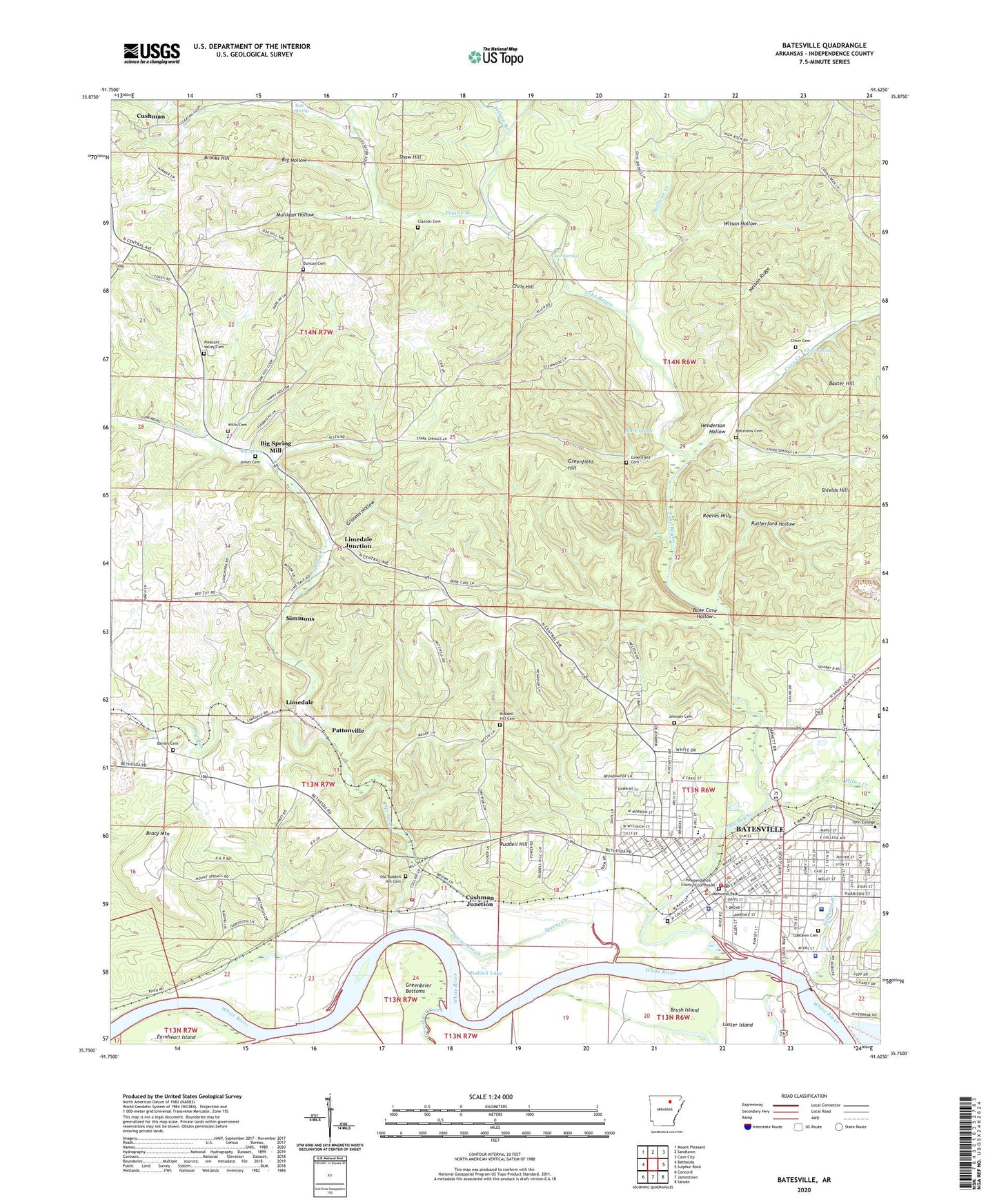
2024 topographic map quadrangle Batesville in the state of Arkansas. Scale: 1:24000. Based on the newly updated USGS 7.5' US Topo map series, this map is in the following counties: Independence. The map contains contour data, water features, and other items you are used to seeing on USGS maps, but also has updated roads and other features. This is the next generation of topographic maps. Printed on high-quality waterproof paper with UV fade-resistant inks.
Quads adjacent to this one:
West: Bethesda
Northwest: Mount Pleasant
North: Sandtown
Northeast: Cave City
East: Sulphur Rock
Southeast: Salado
South: Jamestown
Southwest: Concord
This map covers the same area as the classic USGS quad with code o35091g6.
Contains the following named places: 16th Judicial District Drug Task Force, 72501, A R Chin Prospect, Adler Mine, Allen Mine, Asbury Methodist Church, Barnes Cemetery, Batesville, Batesville Commercial Historic District, Batesville Country Club, Batesville Early Learning and Enrichment Center, Batesville East Main Historic District, Batesville Fire Department Station 1, Batesville Institute, Batesville Intermediate School, Batesville Post Office, Batesville Water Carnival Stadium, Baxter Hill, Baxter Prospects, Belleview Cemetery, Belleview School, Bethel African Methodist Episcopal Church, Bethlehem Baptist Church, Big Hollow, Big Spring, Big Spring Mill, Blowing Cave, Bone Cave Hollow, Bracy Mountain, Brooks Hill, Brooks Hill Mine, Brush Island, Burge Mine, Button Mine, Calvary Baptist Church, Cason Mine, Cave Creek, Cave Spring, Central Avenue Church of Christ, Central Magnet Elementary School, Champlain Prospect, Chinn Cemetery, Chinn Spring, Chris Hill, Claxton Cemetery, Climer Prospect, Collins Prospect, Community School, Criswell Prospect, Cushman Junction, Daffin Field, Deener Prospect, Denieville, Denison Mine, Dry Run, Dry Run School, Duncan Cemetery, Earnheart Island, East Elementary School, Faith Cumberland Presbyterian Church, First Assembly of God Church, First Baptist Church, First Church of the Nazarene, First Freewill Baptist Church, First Presbyterian Church, First United Methodist Church, Fitzhugh Park, Fortune Prospect, Friendship Baptist Church, Gainer Ferry, Grapevine Hill, Grays Hospital, Greenbrier Bottoms, Greenbrier Creek, Greenbrier Ferry, Greenfield Cemetery, Greenfield Hill, Grooms Hollow, Haigwood Prospect, Harrison Street Church of Christ, Henderson Hollow, Huff Church, Independence County Courthouse, Independence County Fairgrounds, Independence County Sheriff's Department, J B Thompson Prospect, J W Greenfield Prospect, James Cemetery, James Switch, John Patterson Prospect, Johnson Cemetery, KBTA-AM (Batesville), Kelley Prospect, Kennedy Park, KGED-FM (Batesville), Kingdom Hall of Jehovahs Witnesses, Lake Unico, Landmark Baptist Academy, Landmark Baptist Church, Liberty Temple, Limedale, Limedale Junction, Lock 1, Lock and Dam Number One, Luster Island, Marshall Mine, Martha Thompson Mine, Masonic Orphans Home, Meadow Heights, Memorial Park, Miller Creek, Miller-Rhinehart Washer, Mountain Spring School, Mulligan Hollow, Nelson Ridge, North Arkansas Christian School, North Heights Church of Christ, Oak Hill School, Oaklawn Cemetery, Odd Fellows Widows and Orphans Home, Old Ruddell Hill Cemetery, Original Campus Arkansas College, Our Lady of the Blessed Sacrement Church, Pattonville, Pegg Addition, Perrin Mine, Pleasant Valley Cemetery, Poke Bayou, Prairie Branch, R T Patterson Mine, Ramsey Ferry, Red Cut School, Reeves Hills, Riverside Park, Roberts Mine, Ruddell Hill, Ruddell Hill Baptist Church, Ruddell Hill Cemetery, Ruddell Hill Rural Fire Department, Ruddell Lake, Ruddell School, Rudell School, Rutherford Hollow, Rutherford Mine, Saint Fidelis Catholic Church, Saint Marys Catholic Church, Saint Pauls Episcopal Church, Scheid Quarry, Shaw Hill, Shaw Mine, Shell Mine, Shields Hills, Simmons, Simmons Prospect, Simpson Slough, Soulesbury College, Southerland Park Golf Course, Spring Creek, Spring Mill Church, Stark Spring, Stillhouse Branch, Sullivan Creek, Sun Valley Addition, The Church of Jesus Christ of Latter Day Saints, Town Plaza Shopping Center, Township of Ashley, Township of Cushman, Township of Ruddell, Twentieth Street Baptist Church, Vital Link Emergency Medical Services, W L Greenfield Mine, W W Allen Mine, Waco Prospect, Walter Chinn Prospects, Weaver-Dowdy Prospect, West Baptist Church, West Magnet Elementary School, White River Medical Center, White River Medical Center Heliport, White River Regional Library, Wildcat Mine, Willis Cemetery, Wilson Branch, Wilson Hollow