MyTopo
Bethesda Arkansas US Topo Map
Couldn't load pickup availability
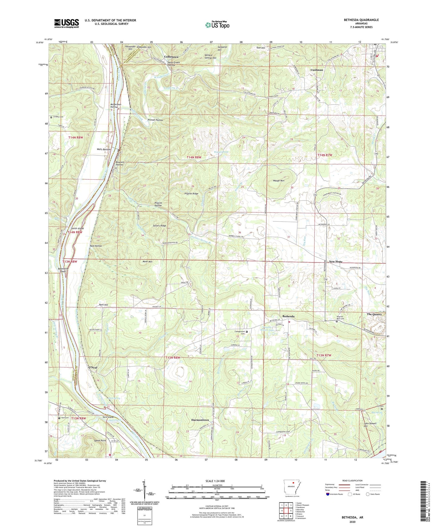
2024 topographic map quadrangle Bethesda in the state of Arkansas. Scale: 1:24000. Based on the newly updated USGS 7.5' US Topo map series, this map is in the following counties: Independence, Stone, Izard. The map contains contour data, water features, and other items you are used to seeing on USGS maps, but also has updated roads and other features. This is the next generation of topographic maps. Printed on high-quality waterproof paper with UV fade-resistant inks.
Quads adjacent to this one:
West: Marcella
Northwest: Guion
North: Mount Pleasant
Northeast: Sandtown
East: Batesville
Southeast: Jamestown
South: Concord
Southwest: Drasco
This map covers the same area as the classic USGS quad with code o35091g7.
Contains the following named places: Alder Creek, Arkansas Sheriffs Boys Ranch, Arnold Branch, Batesville Shoal, Bethesda, Bethesda Campground Church, Bethesda Census Designated Place, Bethesda Rural Fire Department, Biltmore Siding, Blue Spring, Blue Spring Branch, Button Prospect, Campground Cemetery, Chapel Creek, Chinquapin Church, Chinquapin School, City of Cushman, Collietown, Cushman, Cushman Elementary School, Cushman High School, Cushman Post Office, Cushman Volunteer Fire Department, Dave Green Hollow, Duck River, Earnhearts Ferry, East Lafferty Creek, F M Barnes Prospect, Frazier Prospect, George Mine, Gill Cemetery, Glenn Creek, Glenn Slough, Grigsby Ferry, Harmon Creek, Harmontown, Harvey Mine, Hightower Prospect, Independence Church Camp, Independence School, Jake Cole Prospect, John Dowell Hill, Kimbrough Mine, Lafferty Creek, Limeville, Lindsey Cemetery, Lock and Dam Number Three, Lock and Dam Number Two, Martin Mines, Martin Public Access, McBride Mines, McDermon Hollow, Melrose Fire Department, Melrose Volunteer Fire Department, Mill Creek, Mose Mountain, Mountain Springs School, Ned Hollow, New Hope, New Hope Church, Oak Grove School, O'Neal, O'Neal Creek, O'Neal School, Park Hill, Penters Bluff, Phosphate, Pilgrim Hollow, Pilgrim Ridge, Pilgrims Rest Baptist Church, Pilgrims Rest Cemetery, Pitman Hollow, R W Reeves Prospect, Reeds Chapel, Rocky Branch, Rowlett Hollow, S W George Mine, Safley Pond, Salt Creek, Section 8 Prospect, Sellers Ridge, Shaft Hill Mine, Smith Island, South Hill Prospect, Speak Point, Spout Spring, Still Spring Branch, The Quarry, Tosh Hill, Tosh Hill Prospect, Township of Cushman-Union, Township of Washington, U N Dobson Prospect, University of Arkansas Agricultural Station, University of Arkansas Experimental Farm, Vaughn Wilson Lake, Vaughn Wilson Lake Dam, W C Collie Mine, Wallace Creek, Walls Bottom, Walls Ferry, Waugh Mountain, Waugh Pond, Webber Chapel School, Webber Spring Branch, West Lafferty Creek, Willard George Hill, Wright Creek, York Cemetery, York Island