MyTopo
Amador City California US Topo Map
Couldn't load pickup availability
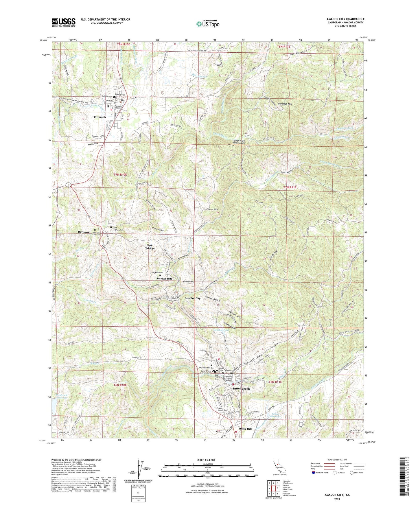
2021 topographic map quadrangle Amador City in the state of California. Scale: 1:24000. Based on the newly updated USGS 7.5' US Topo map series, this map is in the following counties: Amador. The map contains contour data, water features, and other items you are used to seeing on USGS maps, but also has updated roads and other features. This is the next generation of topographic maps. Printed on high-quality waterproof paper with UV fade-resistant inks.
Quads adjacent to this one:
West: Irish Hill
Northwest: Latrobe
North: Fiddletown
Northeast: Aukum
East: Pine Grove
Southeast: Mokelumne Hill
South: Jackson
Southwest: Ione
This map covers the same area as the classic USGS quad with code o38120d7.
Contains the following named places: Allen Family Cemetery, Amador City, Amador City Cemetery, Amador City Post Office, Amador City School, Amador County Fairgrounds, Amador Creek, Amador Fire Protection District Station 122, Amador High School, American Legion Ambulance Station 5, Brignole Building, Bunker Hill, Bunker Hill Mine, Catholic Cemetery, Caucasian Hall, Central Eureka Mine, Central House, Chichizola Building, City of Amador City, City of Plymouth, Claypipers Theatre, Deadman Fork, Department of Forestry and Fire Protection Station 60 Sutter Hill, Drytown, Drytown Census Designated Place, Drytown City Cemetery, Empire Mine, Fleehart Building, Flying Gluepie Ranch Airport, Fremont Mine, Gopher Gulch, Gopher Mine, Henderson Reservoir, Icehouse Pond, Immaculate Conception Catholic Church, Immaculate Conception Parish Cemetery, Independence High School, Indian Gulch, Ione Band of Miwok Tribal Designated Statistical Area, Ione Canal, Italian Mine, Italian Society Park, Jackson Ditch, Kanaka Gulch, Keystone Mine, Kling Building, Knights Foundry, LeMoine House, Lincoln Mine, Little Amador Mine, Lower Rancheria, Main Street Park, Minnie Provis Park, New Chicago, New Protestant Cemetery, North Fork Dry Creek, North Fork Rancheria Creek, North Star Mine, Oak Knoll Cemetery, Odd Fellows Cemetery, Old Eureka Mine, Pacific Mine, Peyton Building, Pioneer Cemetery, Pioneer Mine, Plymouth, Plymouth Baptist Church, Plymouth City Hall, Plymouth Elementary School, Plymouth IOOF Cemetery, Plymouth Post Office, Plymouth Primary School, Pokerville, Quartz Mountain, Rancheria Creek Park, Ratto Theatre, Rock Monument, Roos Building, Saint Marys of the Mountains Catholic Church, Saint Stephens Cemetery, Saint Stevens Catholic Church, Schaeffers Diggins, School Ditch, Seventh Day Adventist School, Snake Gulch, South Eureka Mine, South Fork Dry Creek, South Spring Hill Mine, Stoneridge Winery, Stony Creek, Sutter Creek, Sutter Creek Catholic Cemetery, Sutter Creek City Cemetery, Sutter Creek City Hall, Sutter Creek Elementary School, Sutter Creek Fire Protection District Station 1 Headquarters, Sutter Creek Fire Protection District Station 2, Sutter Creek Grammar School, Sutter Creek Police Department, Sutter Creek Post Office, Sutter Creek Primary School, Sutter Creek United Methodist Church, Sutter Creek-Plymouth Division, Sutter Hill, Sutter Hill Plaza Shopping Center, Sutter Ridge Vineyards, Tanner Reservoir, Torres Hall, Treasure Mine, Trembath Mountain, Trinity Episcopal Church, Weil Building, Whisky Gulch, Youngs Vineyards, ZIP Codes: 95601, 95685, 95699