MyTopo
Bolinas California US Topo Map
Couldn't load pickup availability
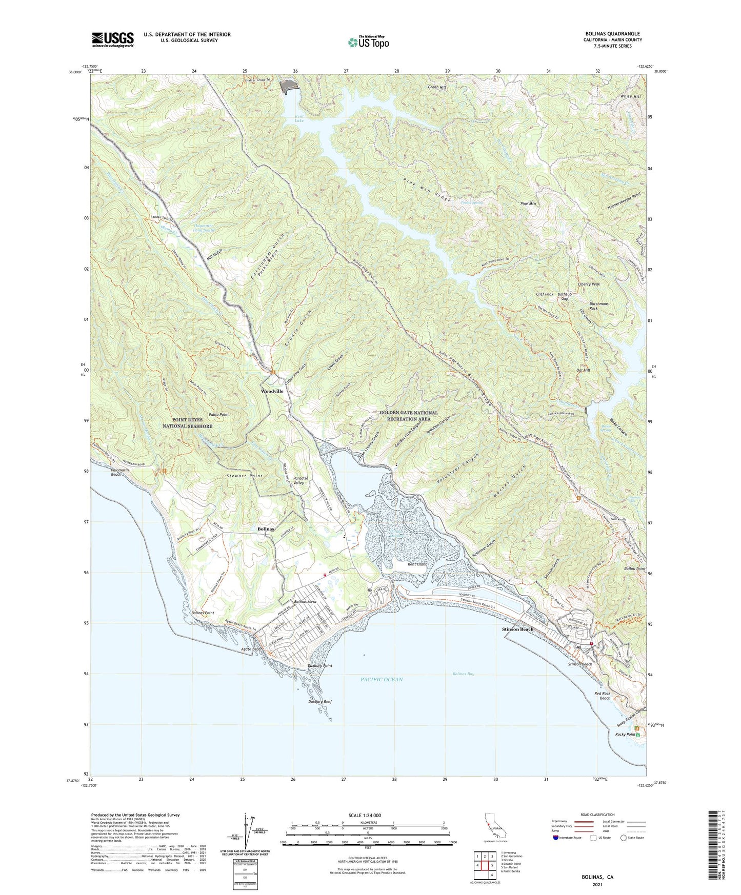
2021 topographic map quadrangle Bolinas in the state of California. Scale: 1:24000. Based on the newly updated USGS 7.5' US Topo map series, this map is in the following counties: Marin. The map contains contour data, water features, and other items you are used to seeing on USGS maps, but also has updated roads and other features. This is the next generation of topographic maps. Printed on high-quality waterproof paper with UV fade-resistant inks.
Quads adjacent to this one:
West: Double Point
Northwest: Inverness
North: San Geronimo
Northeast: Novato
East: San Rafael
Southeast: Point Bonita
This map covers the same area as the classic USGS quad with code o37122h6.
Contains the following named places: Agate Beach, Agate Beach County Park, Alpine 33-000 Dam, Alpine Dam, Alpine Lake, Arroyo Hondo, Audubon Canyon, Audubon Canyon Ranch, Barths Creek, Bathtub Gap, Big Carson Creek, Bishop Pine Grove, Blake Canyon, Bolinas, Bolinas - Stinson Elementary School, Bolinas - Stinson School Stinson Beach Campus, Bolinas Bay, Bolinas Branch Marin County Free Library, Bolinas Census Designated Place, Bolinas Division, Bolinas Fire Protection District, Bolinas Lagoon, Bolinas Lagoon Nature Preserve, Bolinas Mesa, Bolinas Park, Bolinas Point, Bolinas Post Office, Bolinas Quail Refuge, Bourne Trail, Broko Spring, Cataract Creek, Cataract Falls, Cataract Trail, Cliff Peak, Copper Mine Gulch, Cottinham Gulch, Cronin Gulch, Dutchmans Rock, Duxbury Point, Duxbury Reef, East Fork Cataract Creek, East Fork Swede George Creek, Full Circle School Marin, Garden Club Canyon, Green Hill, Hagmaier Dam North, Hagmaier Dam South, Hagmaier Pond North, Hagmaier Pond South, Happersberger Point, Helen Markt Trail, Kent Island, Kent Lake, Las Baulines, Laurel Dell Campground, Laurel Dell Ranch, Lewis Gulch, Liberty Gulch, Liberty Peak, Lily Gulch, Lily Gulch Trail, Lily Lake, Mailliard Camp, McCormick Creek, McCurdy Trail, McKennan Trail, McKinnan Gulch, McKinnan Gulch Mine, Mill Gulch, Morses Gulch, Oat Hill, Old Sled Trail, Pablo Point, Pablo Point Trail, Palomarin Beach, Paradise Valley, Pecks Ridge, Peters 33-007 Dam, Peters Dam, Pike County Gulch, Pine Gulch Creek, Pine Mountain, Pine Mountain Ridge, Pine Mountain Tunnel, Point Reyes Bird Observatory, Poison Spring, Randall Trail, Red Rock Beach, Ridge Trail, Rocky Point, Sargent Cypress Forest, Steep Ravine Canyon, Steep Ravine Environmental Camp, Stewart Point, Stinson Beach, Stinson Beach Branch Marin County Free Library, Stinson Beach Census Designated Place, Stinson Beach Fire Protection District, Stinson Beach Post Office, Stinson Gulch, Swede George Creek, Tomales Y Baulines, Twin Knolls, Volunteer Canyon, Webb Creek, White Hill, Wilkins Gulch, Woodville, ZIP Codes: 94924, 94970