
MyTopo
Vine Hill California US Topo Map
Couldn't load pickup availability
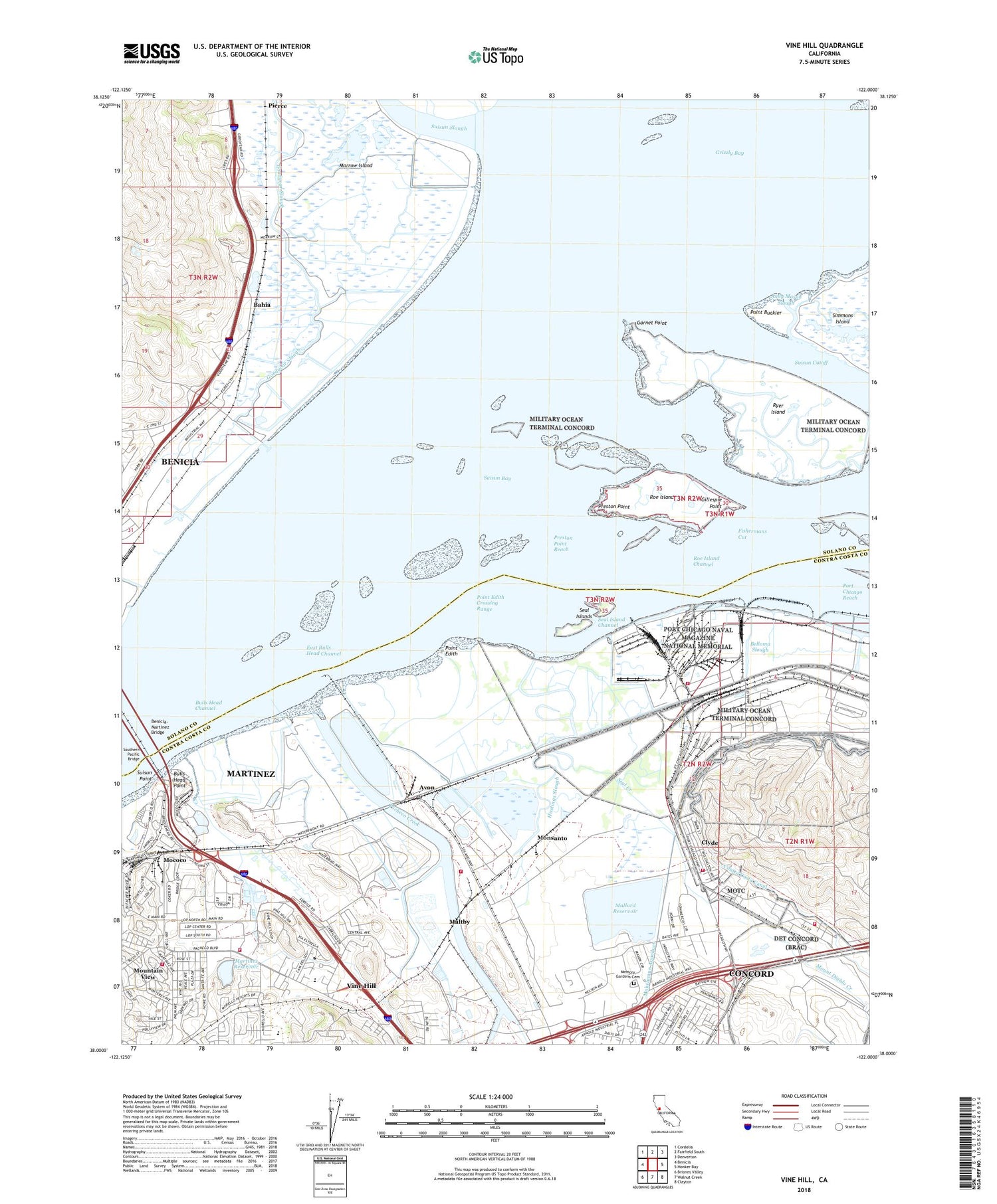
2021 topographic map quadrangle Vine Hill in the state of California. Scale: 1:24000. Based on the newly updated USGS 7.5' US Topo map series, this map is in the following counties: Contra Costa, Solano. The map contains contour data, water features, and other items you are used to seeing on USGS maps, but also has updated roads and other features. This is the next generation of topographic maps. Printed on high-quality waterproof paper with UV fade-resistant inks.
Quads adjacent to this one:
West: Benicia
Northwest: Cordelia
North: Fairfield South
Northeast: Denverton
East: Honker Bay
Southeast: Clayton
South: Walnut Creek
Southwest: Briones Valley
This map covers the same area as the classic USGS quad with code o38122a1.
Contains the following named places: American Medical Response, Andy Mason Slough, Associated Post Office, Avon, Bahia, Bay Point Yacht Harbor, Belloma Slough, Benicia-Martinez Bridge, Berean Christian School, Bulls Head Channel, Bulls Head Point, Church of Christ, Clearwell Phase 2 1082-002 Dam, Clyde, Clyde Census Designated Place, Conrad Viano Winery, Contra Costa County Fire Protection District Station 12, Contra Costa County Fire Protection District Station 18, Diablo Creek Golf Course, East Bulls Head Channel, Echo Island Beacon, Ehmann Club, Federal Fire Station 25, Federal Fire Station 26, Fishermans Cut, Garnet Point, Gillespie Point, Golden Eagle Refinery Fire Department, Goodyear Quarry, Grayson Creek, Grizzly Bay, Hastings Slough, Heald College - Concord, John Muir Elementary School, KVHS-FM (Concord), Las Juntas Elementary School, Mallard 1019 Dam, Mallard Reservoir, Maltby, Martinez Dam, Martinez Reservoir, Martinez Water Purification Plant, Memory Gardens Cemetery, Mococo, Monsanto, Morello Park Elementary School, Morello School Park, Morrow Island, Morrow Island Farm, Mount Diablo Creek, Mount View School, Mountain View, Mountain View Census Designated Place, Mountain View Park, Ohmer, Pacheco Creek, Patchins School, Point Buckler, Point Edith, Point Edith Crossing Range, Port Chicago, Port Chicago Naval Magazine National Memorial, Port Chicago Reach, Preston Point, Preston Point Reach, Roe Island, Roe Island Channel, Ryer Island, Seal Bluff Landing, Seal Creek, Seal Island Channel, Seal Islands, Shell Martinez Refining Company Fire Brigade, Southern Pacific Bridge, Suisun Cutoff, Suisun Point, Suisun Slough, Sulphur Springs Creek, Sun Terrace Elementary School, Sun Terrace Park, Vicini 487 Dam, Vine Hill, Vine Hill Census Designated Place, Vine Hill School, Walnut Creek


