MyTopo
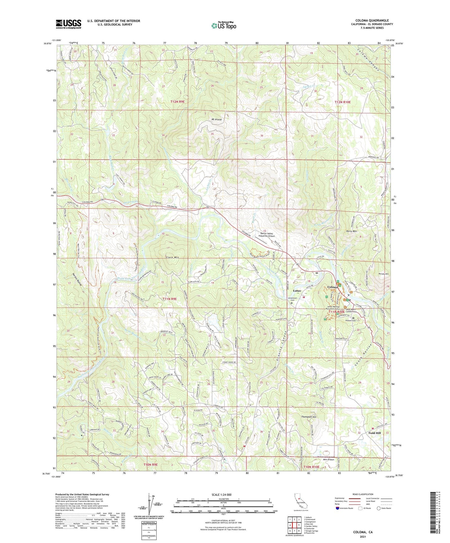
Coloma California US Topo Map
Couldn't load pickup availability
2021 topographic map quadrangle Coloma in the state of California. Scale: 1:24000. Based on the newly updated USGS 7.5' US Topo map series, this map is in the following counties: El Dorado. The map contains contour data, water features, and other items you are used to seeing on USGS maps, but also has updated roads and other features. This is the next generation of topographic maps. Printed on high-quality waterproof paper with UV fade-resistant inks.
Quads adjacent to this one:
West: Pilot Hill
Northwest: Auburn
North: Greenwood
Northeast: Georgetown
East: Garden Valley
Southeast: Placerville
South: Shingle Springs
Southwest: Clarksville
This map covers the same area as the classic USGS quad with code o38120g8.
Contains the following named places: Abrams 3462-002 Dam, Akin Airport, Bacchi 1461 Dam, Bacchi Valley Industries Airport, Beer Garden Picnic Area, Black Rock Creek, Blue Tent Creek, Boulder Mine, Brush Creek, Burnt Shanty Creek, Chuck Ravine, Clark Creek, Clark Mountain, Coloma, Coloma Census Designated Place, Coloma Post Office, Coloma Schoolhouse, Coloma Winery, Delores Mine, Dutch Creek, El Dorado County Fire Protection District Station 27 Gold Hill, El Dorado County Fire Protection District Station 74 Coloma / Lotus, Emmanuel Episcopal Church, Gambler Creek, Gastaldi 1466 Dam, Gold Hill, Gold Hill Vineyard, Gold Trail Union School, Granite Canyon, Granite Creek, Greenwood Creek, Hastings Creek, Indian Creek, Jacobs Creek, Jacobs Creek 53-006 Dam, James Marshall Monument Grave, James W Marshall State Historical Monument, Johntown Creek, Kane House, Koloma, Lichen Creek, Lilyama Mine, Little Gambler Creek, Lotus, Lotus Post Office, Marshall Gold Discovery State Historic Park, Marshall Gold Discovery State Historic Park Museum, Marshalls Cabin, Monroe Ridge Trail, Monument Picnic Area, Monument Trail, Mount Ararat, Murphy Mountain, North Beach Picnic Area, Norton Ravine, Old Coloma Theatre, Papini House, Perry Mountain, Perry Mountain Creek, Pinehem Creek, Pioneer Cemetery, Point Pleasant Bench Picnic Area, Ponderosa Park Picnic Area, Rescue Fire Protection District Station 81, Saint John's Catholic Cemetery, Saint Johns Catholic Church, Schubin 2460 Dam, Shingle Creek, Springvale School, Straza 3462 Dam, Sutters Mill, Sutter's Mill Primary School, Thomas House, Thompson Hill, Uniontown Cemetery, Veerkamp 1465 Dam, Vineyard House, Williamson Number 1 464 Dam, ZIP Code: 95651