MyTopo
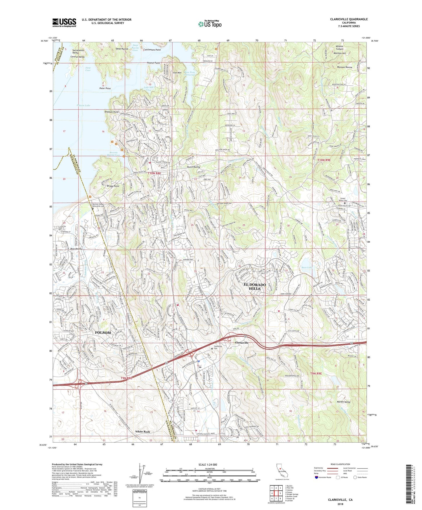
Clarksville California US Topo Map
Couldn't load pickup availability
2021 topographic map quadrangle Clarksville in the state of California. Scale: 1:24000. Based on the newly updated USGS 7.5' US Topo map series, this map is in the following counties: El Dorado, Sacramento, Placer. The map contains contour data, water features, and other items you are used to seeing on USGS maps, but also has updated roads and other features. This is the next generation of topographic maps. Printed on high-quality waterproof paper with UV fade-resistant inks.
Quads adjacent to this one:
West: Folsom
Northwest: Rocklin
North: Pilot Hill
Northeast: Coloma
East: Shingle Springs
Southeast: Latrobe
South: Folsom SE
Southwest: Buffalo Creek
This map covers the same area as the classic USGS quad with code o38121f1.
Contains the following named places: Allegheny Creek, Arroyo Vista, Art Weisburg Park, Bar J Ranch, Bass Lake, Blue Oak Elementary School, Blue Ravine, Briarwood Canyon, Bridge Point, Briggs Ranch Neighborhood Park, Broadstone Mall, Broadstone Mall Shopping Center, Browns Ravine Cove, Browns Ravine Recreation Area, Cambridge Oaks, Camerado Springs Middle School, Carson Creek Watershed Reservoir, Cattlemans Point, Clarksville, Clarksville Cemetery, Crescent Ridge Park, Crescent Ridge Village, Crocker Creek, Crown Village, Deep Ravine, Deep Ravine Cove, Dutch Ravine, El Dorado County Sheriff's Office - Town Center Substation, El Dorado Hills, El Dorado Hills 53-008 Dam, El Dorado Hills Archery Range, El Dorado Hills Business Park, El Dorado Hills Census Designated Place, El Dorado Hills Community Park, El Dorado Hills Fire Department Station 84, El Dorado Hills Fire Department Station 85 Headquarters, El Dorado Hills Fire Department Station 86, El Dorado Hills Fire Department Station 87, El Dorado Hills Golf Course, El Dorado Hills Post Office, El Dorado Hills Village Center Shopping Center, El Dorado Marina, Empire Oaks Elementary School, Equestrian Village, First Cove, Folsom Lake, Folsom Marina Boat Ramp, Folsom Saddle Dam, Franciscan Village, Governors Village, Green Spring Creek, Green Springs Ranch, Green Springs Valley, Green Valley Acres, Green Valley Cemetery, Green Valley Elementary School, Hickok Ranch, Hidden Valley, Highland Village, Iron Mountain, Jackson Elementary School, KKSA-AM (Folsom), Knoxton Point, KQPT-FM (Sacramento), KRAK-FM (Sacramento), KWOD-FM (Sacramento), KZAP-FM (Sacramento), La Cresta Village, Lake Forest Elementary School, Lake Hill Cove, Lake Hills Estates, Lakeridge Oaks, Live Oak School, Manzanita Acres, Marble Mountain, Marble Valley Quarry, Marina Village, Marina Village Intermediate School, Martel Creek, Mormon Hill, Mormon Hill Mine, Mormon Island Dam, Mormon Island Relocation Cemetery, Mormon Island School, Mormon Island Wetlands Natural Preserve, Mormon Island Wetlands State Park, Natomas Ditch, Negro Hill School, New Bass Lake 53-007 Dam, New York Creek, New York Creek Cove, Oak Creek Hills, Oak Ridge High School, Oak Ridge Village, Oak Tree Village, Oakridge-Eldorado Hills Branch El Dorado County Library, Park Village, Peanut Point, Peter Point, Pleasant Grove House State Historic Landmark, Pony Express Station Historic Site, Prewitt Park, Ridgeview Park, Ridgeview Village, Saint Andrews Park, Saint Andrews Village, Screech Owl Creek, Silva Valley Elementary School, South Fork American River, South Shore Riding and Hiking Trail, Springfield Meadows, Stonegate Village, Summit Village, Sunset Mobile Home Park, Sweetwater Basin Wildlife Area, Waterford Village, White Rock, William Brooks Elementary School, Willow Creek Mini Park, Winterhaven Village, ZIP Code: 95762