MyTopo
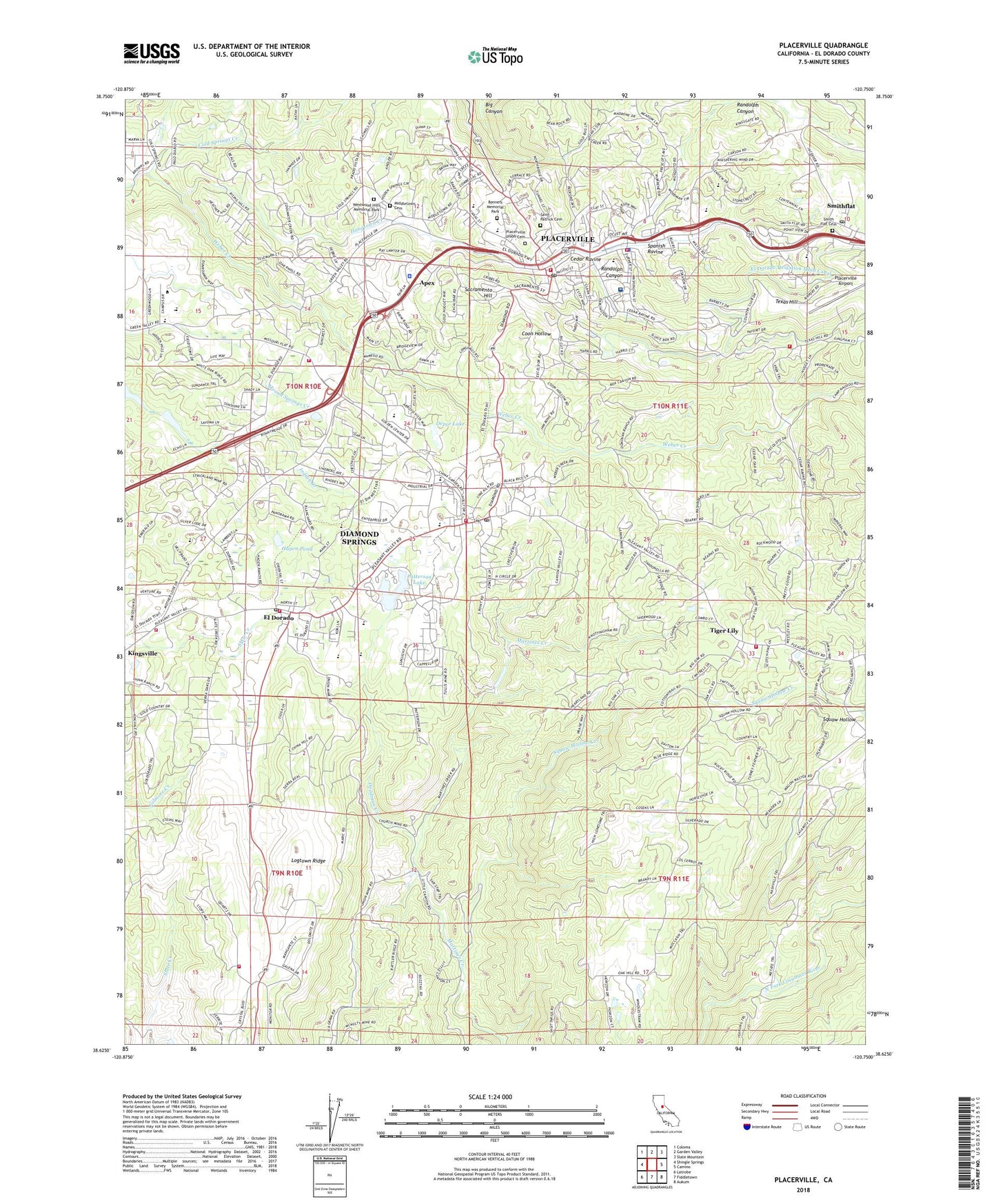
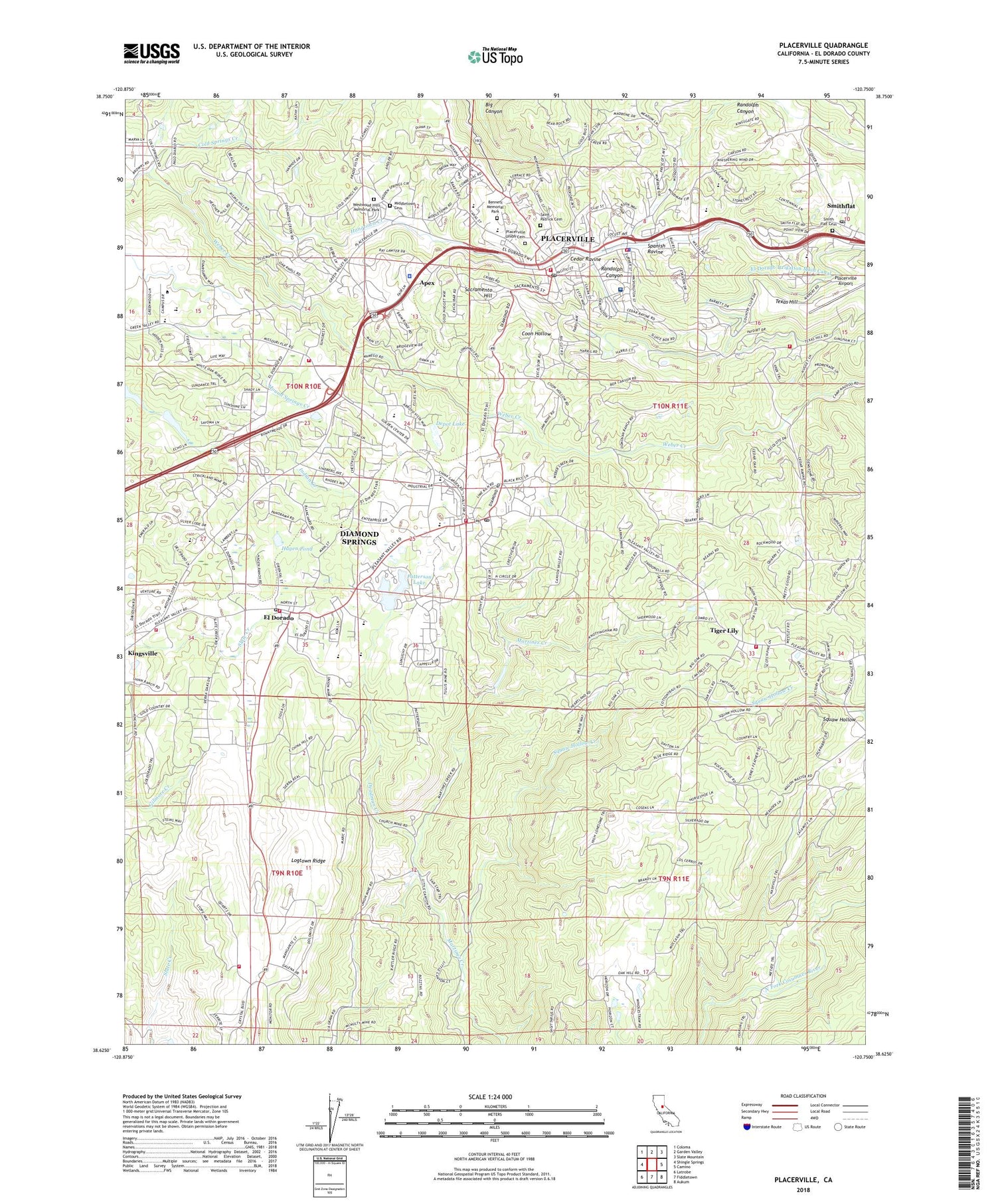
Placerville California US Topo Map
Couldn't load pickup availability
2023 topographic map quadrangle Placerville in the state of California. Scale: 1:24000. Based on the newly updated USGS 7.5' US Topo map series, this map is in the following counties: El Dorado. The map contains contour data, water features, and other items you are used to seeing on USGS maps, but also has updated roads and other features. This is the next generation of topographic maps. Printed on high-quality waterproof paper with UV fade-resistant inks.
Quads adjacent to this one:
West: Shingle Springs
Northwest: Coloma
North: Garden Valley
Northeast: Slate Mountain
East: Camino
Southeast: Aukum
South: Fiddletown
Southwest: Latrobe
This map covers the same area as the classic USGS quad with code o38120f7.
Contains the following named places: American River College Placerville Campus, Apex, Bennett Memorial Park, California Highway Patrol Valley Division - Placerville, Caswell Ranch, Cedar Ravine, Charles F Brown Elementary School, Church Mine, City of Placerville, Cold Spring School, Cold Springs, Cold Springs Cemetery, Cold Springs Census Designated Place, Cold Springs Creek, Confidence Hall, Coon Hollow, Coon Hollow School, County Fair Shopping Center, Crusader Mine, Deadman Creek, Deer Park, Department of Forestry and Fire Protection Station 43 El Dorado, Depot Lake, Diamond Spring State Historic Landmark, Diamond Springs, Diamond Springs - El Dorado Fire Protection District Station 44, Diamond Springs - El Dorado Fire Protection District Station 48, Diamond Springs - El Dorado Fire Protection District Station 49 Headquarters, Diamond Springs Census Designated Place, Diamond Springs Post Office, Diamond Springs Quarry, Discovery Plaza Shopping Center, Edwin Markham Middle School, El Dorado, El Dorado Cemetery, El Dorado County Courthouse, El Dorado County Fairgrounds, El Dorado County Federated Church, El Dorado County Fire District Station 25, El Dorado County Fire District Station 26 - Placerville, El Dorado County Fire Protection District Station 23 Oak Hill, El Dorado County Fire Protection District Station 24, El Dorado County Hospital, El Dorado County Jail, El Dorado County Law Library, El Dorado County Library, El Dorado County Psychiatric Health Facility, El Dorado County Sheriff's Office Placerville, El Dorado Fire District Station 46, El Dorado High School, El Dorado Historical Museum, El Dorado Irrigation Main Canal, El Dorado Post Office, Eldorado National Forest Headquarters, Enchs Smokey Ridge Ranch, Episcopal Church of Our Saviour, First Church of Christ Scientist, Fountain and Tallman Soda Factory Museum, Full Gospel Church, Gold Bug Mine, Hagen Pond, Hangtown Creek, Hangtown Gold Bug Park, Hangtown Orchards, Hanks Exchange, Herbert C Green Middle School, Indak, Independence Continuation High School, Indian Creek Elementary School, Jewish Pioneer Cemetery, KCMY-TV (Sacramento), KLIQ-FM (Shingle Springs), KWWN-FM (Placerville), Lions Park, Logtown, Logtown Ridge, Lookout Mine, Louisiana Schnell Elementary School, Lumsden Park, Marshall Hospital, Meyer Ranch, Middletown Cemetery, Missouri Flat, Missouri Flat School, Moreys Foundry, Oak Hill School, Odd Fellows Cemetery, Old Placerville City Cemetery, Old Stamp Mill, Patterson 2467 Dam, Patterson Lake, Perks Corner, PG and E-Placerville Service Center Heliport, Placerville, Placerville Academy, Placerville Airport, Placerville Christian School, Placerville City Hall, Placerville City Park, Placerville City Police Department, Placerville Division, Placerville Post Office, Placerville Public School, Placerville Sanatorium, Placerville Union Cemetery, Placerville-Camino Junior Academy, Prospector Plaza Shopping Center, Randolph Canyon, Ringgold Creek, Rotary Park, Sacramento Hill, Saint Patrick Cemetery, Shaw Mine, Sierra Elementary School, Sierra Golf and Country Club, Sigwarts Opera House, Smith Flat Cemetery, Smith Flat Post Office, Smith Flat School, Smithflat, Spanish Ravine, Squaw Hollow, Squaw Hollow Creek, Starlight Mine, Sundance Tree Farm, Texas Hill, The Carriage Trade Shopping Center, The Gates Recovery Foundation, Tiger Lily, Union Mine, Upper Town Public School, Uppertown Cemetery, Veterans Memorial Building, Westwood Hills Memorial Park, ZIP Codes: 95619, 95667