MyTopo
Cotati California US Topo Map
Couldn't load pickup availability
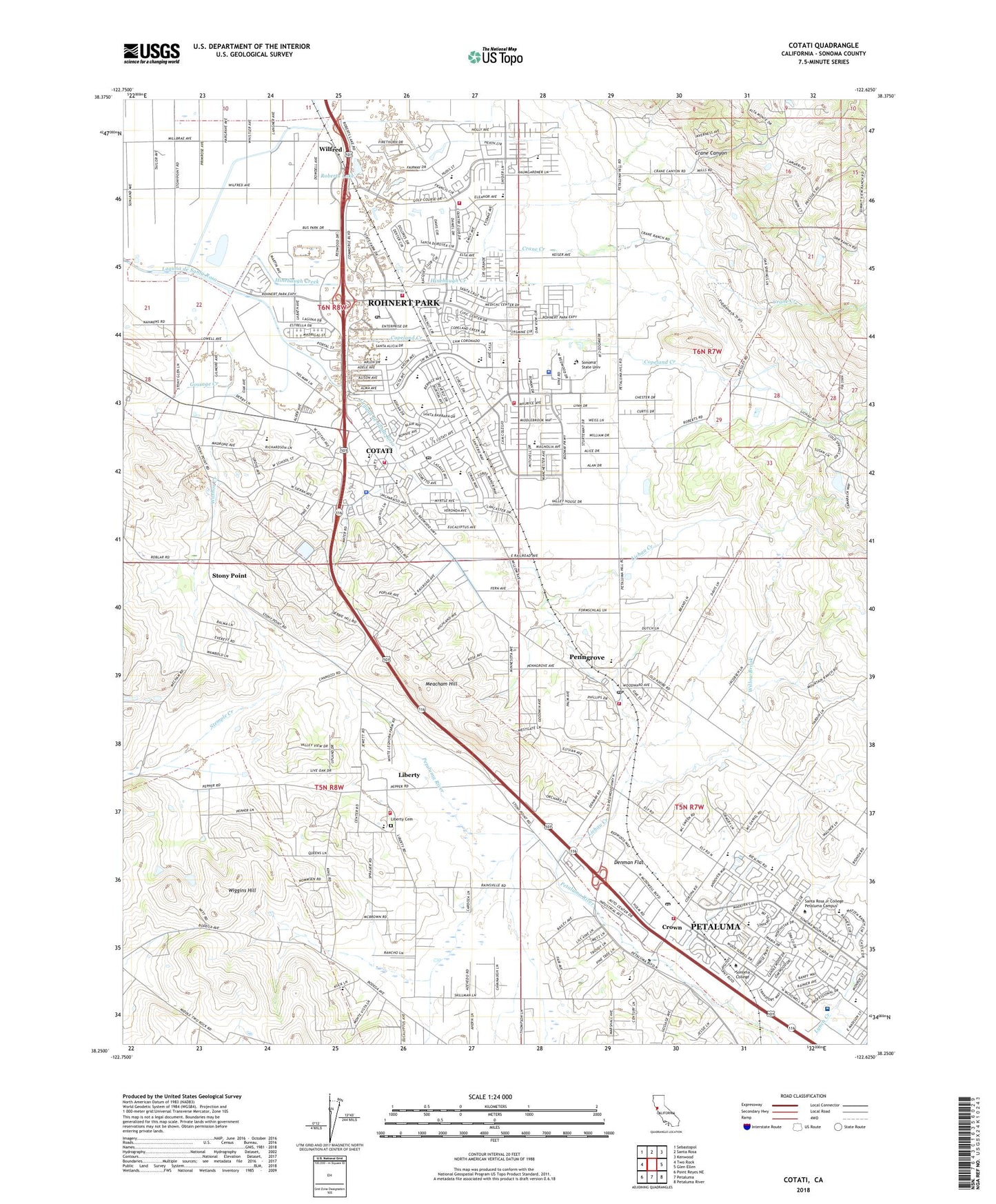
2021 topographic map quadrangle Cotati in the state of California. Scale: 1:24000. Based on the newly updated USGS 7.5' US Topo map series, this map is in the following counties: Sonoma. The map contains contour data, water features, and other items you are used to seeing on USGS maps, but also has updated roads and other features. This is the next generation of topographic maps. Printed on high-quality waterproof paper with UV fade-resistant inks.
Quads adjacent to this one:
West: Two Rock
Northwest: Sebastopol
North: Santa Rosa
Northeast: Kenwood
East: Glen Ellen
Southeast: Petaluma River
South: Petaluma
Southwest: Point Reyes NE
This map covers the same area as the classic USGS quad with code o38122c6.
Contains the following named places: Alicia Park, Benicia Park, Berean Baptist Christian Academy, Blackberry Creek Farm, Bond Park, California Highway Patrol Golden Gate Division - Santa Rosa, California Virtual Academy, Camozzi Brothers Dairy, Caterpillar Park, Cator Field, Cherry, Church of the Oaks, Cinnabar Elementary and Charter School District, City of Cotati, City of Rohnert Park, Colegio Vista Park, Community Day School, Copeland Creek, Copeland School, Corona, Corona Creek Elementary School, Cotate, Cotati, Cotati City Hall, Cotati Middle School, Cotati Naval Auxiliary Air Station, Cotati Police Department, Cotati Post Office, Crane Canyon, Crane Creek, Crane Creek Regional Park, Cross and Crown Lutheran School, Crown, Denman, Denman Flat, Dorotea Park, Eagle Park, Eagle Ridge Winery, Ely, Evergreen Elementary School, Faith Presbyterian Church, First Baptist Church of Rohnert Park, Five Creek, Gold Ridge Elementary School, Gossage Creek, Grapevine Shopping Center, Helen Putnam Park, Hinebaugh Creek, Hinebaugh Park, John Reed Elementary School, Kenilworth Junior High School, Kotate Park, KRRS-AM (Santa Rosa), Lady Bug Park, LaPlaza Park, Lawrence E Jones Middle School, Leisure Lake Mobile Home Park, Liberty, Liberty Cemetery, Liberty Elementary School, Liberty Valley Golf Course, Lichau Creek, Loma Vista Immersion Academy, Lucchesi Park, Marguerite Hahn Elementary School, Meacham Hill, Meadow Elementary School, Meadow Pines Park, Monte Vista Elementary School, Mountain Shadows Golf Course, Mountain Shadows Middle School, North Bay P and DC Finance Post Office, North San Francisco Bay-McDowell Industrial Park, Northbay Centre Shopping Center, Padre Town Center Shopping Center, Park Plaza Shopping Center, Penngrove, Penngrove Census Designated Place, Penngrove Community Church, Penngrove Elementary School, Penngrove Post Office, Petaluma Community Center, Petaluma Division, Petaluma Factory Outlets Shopping Center, Petaluma Fire Department Station 2, Petaluma Industrial Park, Phoenix High School, Pro Transport 1 Ambulance, Providence Petaluma Valley Hospital, Raleys Towne Centre Shopping Center, Rancho Adobe Fire Protection District Cotati Station, Rancho Adobe Fire Protection District Station 2 Headquarters, Rancho Adobe Fire Protection District Station 3, Rancho Arroyo Business Park, Rancho Bodega School, Rancho Cotate High School, Rancho Cotati Shopping Center, Redwood Business Park, Reichardt Duck Farm, Richard Crane Elementary School, Roberts Lake, Roberts Lake Park, Roblar De La Miseria, Rohnert Park, Rohnert Park Assembly of God Church, Rohnert Park City Hall, Rohnert Park Department of Public Safety Fire Division Station 3, Rohnert Park Fire Division Main Station, Rohnert Park Fire Division Northern Station, Rohnert Park Fire Division Southern Station, Rohnert Park Post Office, Rohnert Park Sewage Treatment Plant, Rohnert Park Stadium, Rohnert Park-Cotati Branch Sonoma County Library, Ruben Salazar Library, Santa Rosa Junior College Petaluma Campus, Snyder Lane Christian School, Sonoma College, Sonoma Life Support Post 17, Sonoma Mountain Elementary School, Sonoma State University, Sonoma State University Campus Police Department, Sonoma State University Census Designated Place, South Point Business Park, Steuben School, Stevenson Hall, Stony Point, Stony Point Rock Quarry, Stony Point School, Sunrise Park, Technology High School, Thomas Page Elementary School, University Elementary School At La Fiesta, Veterans Memorial Building, Waldo Rohnert Elementary School, Washoe, Washoe Creek, Waugh School, Wiggins Hill, Wilfred, Willow Brook, ZIP Codes: 94928, 94931, 94951