MyTopo
Petaluma California US Topo Map
Couldn't load pickup availability
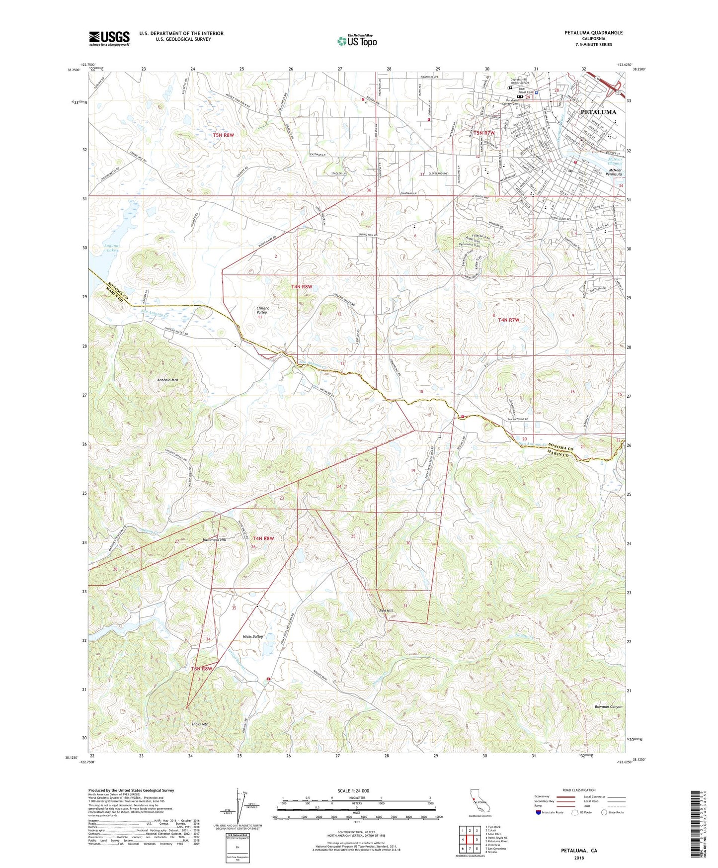
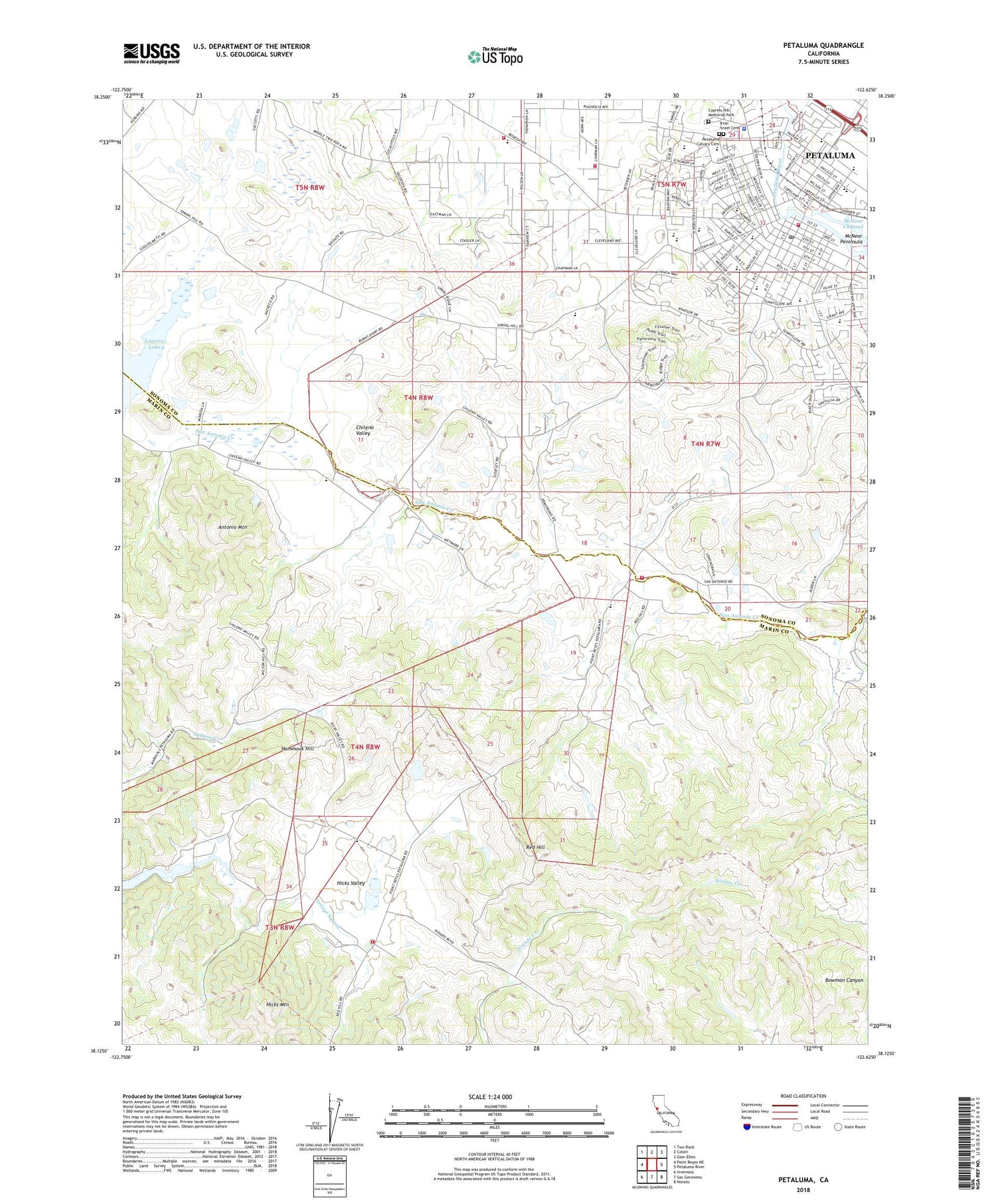
2021 topographic map quadrangle Petaluma in the state of California. Scale: 1:24000. Based on the newly updated USGS 7.5' US Topo map series, this map is in the following counties: Marin, Sonoma. The map contains contour data, water features, and other items you are used to seeing on USGS maps, but also has updated roads and other features. This is the next generation of topographic maps. Printed on high-quality waterproof paper with UV fade-resistant inks.
Quads adjacent to this one:
West: Point Reyes NE
Northwest: Two Rock
North: Cotati
Northeast: Glen Ellen
East: Petaluma River
Southeast: Novato
South: San Geronimo
Southwest: Inverness
This map covers the same area as the classic USGS quad with code o38122b6.
Contains the following named places: Antonio Mountain, Bluesberry Farms, B'nai Israel Cemetery, Brazil Dairy, Cal Fire Petaluma Fire Station, Calvary Life Christian School, Calvary Life United Pentecostal Church, Carpe Diem High School, Cherry Valley Park, City of Petaluma, Congregational B'nai Israel, Corte Madera De Novato, Crossroads Community Day School, Cypress Hill Memorial Park, Dolcini 431 Dam, East Petaluma, Elim Lutheran Church, Evangelical Free Church, Fashion Livery Stable, First Assembly of God Church, First Christian Church, First Church of Christ Scientist, First Church of God, First Congregational Church, Five Corners Community Center, Foundry Wharf Business Park, Golden Eagle Shopping Center, Grant Elementary School, Great Petaluma Mill Shopping Center, Hammock Hill, Happy Day Presbyterian School, Helen Putnam Regional Park, Herold Building, Hicks Mountain, Hicks Valley, Hill Plaza Park, Hillside Hospital, Iowa School, Kenilworth Park, Laguna De San Antonio, Laguna Elementary School, Laguna Lake, Liberty Park, Lincoln Elementary School, Lincoln Primary School, Live Oak Charter School, Lynch Creek, Marin County Fire Department Hicks Valley, Marin School, Mary Collins School at Cherry Valley, McKinley Elementary School, McNear Building, McNear Channel, McNear Elementary School, McNear Park, McNear Peninsula, Muleroad Depot, Mystic Theatre, Oak Hill Park, Open Door Christian Church, Petaluma, Petaluma Branch Sonoma County Library, Petaluma Calvary Cemetery, Petaluma City Hall, Petaluma Fire Department Station 1 Headquarters, Petaluma High School, Petaluma Historical Museum and Library, Petaluma Junior High School, Petaluma Marina, Petaluma Plaza Shopping Center, Petaluma Police Department, Petaluma Post Office, Petaluma Swim Center, Petaluma Town Plaza Shopping Center, Petaluma Yacht Club, Phillip Sweed School, Phoenix Theater, Plaza North Shopping Center, Prince Building, Putman Plaza Park, Red Hill, Saint Johns Episcopal Church, Saint Johns Lutheran Church, Saint Vincent de Paul Catholic Church, Saint Vincent de Paul Elementary School, Saint Vincent De Paul High School, Saint Vincent High School, San Antonio High School, San Antonio Volunteer Fire Department Station 2, Shollenberger Park, Sonoma-Marin Fairgrounds, Soulajule, Spaletta Ranch, Taverna Dairy, The Spring Hill School, Town and Country Shopping Center, Union Elementary School, United Methodist Church of Petaluma, Valley Oaks Elementary School, Valley Oaks Independent Study School, Valley Vista Elementary School, Valley Vista School, Volpi Dairy, Vonsen 430 Dam, Walnut Park, Wickersham Park, Willow Tree School, Wilmar Volunteer Fire Department, Wilson Elementary School, Wilson School